

1-day via Quien Sabe glacier carryover with a group of 9.
Gpx
https://www.gaiagps.com/datasummary/track/70a7c6ed2d0cd6813d13a74062ce7e96/
Pics
https://photos.app.goo.gl/C4gi5wZtqMgb6T4x5
Report
The initial approach was a mix of overgrown trail, and steep, muddy and rocky trail. Think of mailbox old trails and it definitely gets your heart pumping and keeps you awake in the early morning :) A few stream crossings where we easily hopped on rocks, with the help of trekking poles to balance. We each only carried 1.5-2L of water, knowing there will be running water at the Boston camp, just under 3mi in.
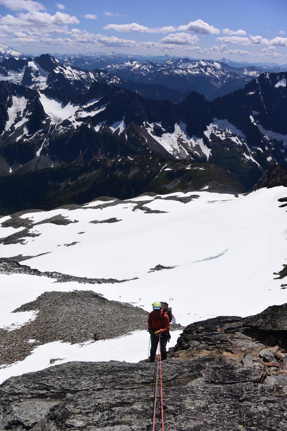
Continuous snow started at 6,800ft where we entered the Quien Sabe glacier. We roped up and put on crampons in the last rock island. Saw some scattered rocks in the glacier (recent rockfall?). Crossed a snow bridge at ~7,600ft above and to the left of a bergschrund. Most parties did this way and saw one party took the more direct and steeper route to the right of the bergschrund. Another snow bridge at ~8,100ft where there were huge open crevasses on both sides. Both snow bridges seemed solid. Just keep the rope taut and have one person cross at a time. Snow slope steepened from here, we walked sideways, and kicked in the crampons' side points, until we reached the Boston-Sahale col, which was a loose rock island with a dusting of snow. Unroped (didn't rope up again), removed crampons and put away ice axe before traversing right to short section of a loose pile of rocks, huge exposure/dropoff on both sides, no fall zone. Put on crampons and took out ice axe before getting back to snow (cornice on the left side) scramble, exposure on the right side, another no fall zone, deeply kicked in steps on a rising traverse, might seem sketchy from distance but was actually an easy walk across. Final stretch to the summit block was a steeper slope with well beaten path.
Summit block was an exposed rock scramble. We waited at the base for over an hour for another party of 3 to climb. Our leader was belayed out with a 30m rope. He carried a few chocks and 0.5 and 0.75 cam, but basically free solo'd up and only used a 0.75 cam. The rest of the group prusiked up and the last person was belayed from above to prevent rope from getting stuck.Solid and blocky rocks with grippy and positive handholds, and many cracks as footholds. Summit block was very crowded. Our group of 9 were there waiting for another party of 3 to rappel.
Well established rappel station with multiple webbings around a huge boulder and rap rings on the summit. We rappelled off double 30m ropes to some loose rocks before entering a short section of steep and firm snow, probably 40-45 degree slope angle, the only sketchy part of the climb IMO. Took out ice axe. More experienced people were comfortable plunge stepping it and crampons helped.Less experienced climbers might appreciate coaching on footing. We had one leader stay on the base of rappel until all others were comfortable enough downclimbing. Most people face-in downclimbed it, very well kicked in steps and even ice axe holes. Then some loose scree and rock scramble, followed by a traverse and plunge stepping down a gentle snow slope (one short glissade chute where most people didn’t even bother taking) to the Sahale glacier camp. You gotta check out the toilet with the panoramic view of the north cascades! No running water at the camp. From there, we entered the snow-free Sahale Arm trail, where we started our uneventful and easy descent. Too much heat and trail was exposed directly under the sun... An obvious dirt path in some loose scree. About 20mins down from the camp, we refilled water again from a stream for the rest of the descent. From the cascade pass, turn right and thankfully the rest of the trail was mostly in the shade. Many switchbacks towards the end.
Water refill stops
- 5,900ft, 2.4mi in (Boston camp)
- 7,500ft (below Sahale glacier camp)
Stats
0530 Boston basin TH (3,263ft)
0820 Boston camp (5,928ft, 2.41mi)
0910 Quien Sabe glacier (6,876ft, 3.04mi) - Rope up and crampon on
1140 Boston-Sahale col (8,506ft, 4.12mi)
1230 Base of summit block (8,690ft, 4.24mi)
1410 Everyone on the summit (8,709ft, 4.26mi)
1530 Everyone off rappel
1630 Sahale glacier camp (7,607ft, 4.99mi)
1830 Cascade pass (5,396ft, 7,32mi)
2000 Cascade pass TH (3,658ft, 10.79mi)
Total: 5,360ft of elevation gain over 10.79mi in 14h40m.
Individual gear
For glacier travel, crevasse rescue, prusiking up a fixed line and extended rappel. Much sun protection from head to toes.
Group gear
Water filter, and emergency gear.


Comments