

Day 1: TH to Silesia Camp - 8mi
Wonderful first day of hiking. Being that we were staying at Silesia Camp (which is a dry camp, unless you want to hike the additional mile roundtrip down to Egg Lake), we had to plan a bit of a water carry. The last water crossing was just before Boundary Camp, so we packed up 7 liters of water between the two of us and hiked the final 3 miles to Silesia. Between the remaining hiking for the day, cooking meals, generally keeping hydrated, and the next 3 miles to Copper Lake the next morning, we were able to make it last and avoid the trip down to Egg Lake. We had a magical sunset and had a great night of sleep to end the day.
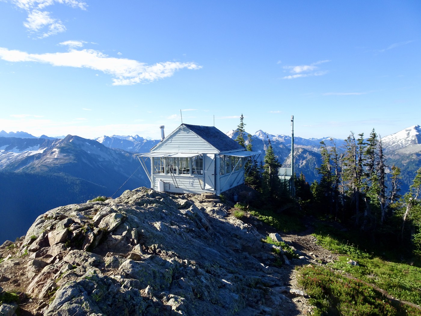
Day 2: Silesia Camp to Graybeal Camp - 16mi
The day started with the climb up to the lookout tower. Absolutely stunning views all along the climb and especially at the top. We stopped for a nice snack before heading out on our way - we paused again after descending to Copper Lake to finally refill our water. The trail from this point to the start of the forest was pretty tough - some places were quite overgrown and narrow in spots and others were just very loose/unstable rock. Once we made it into the forest, we really lucked out - all but 10 or so blowdowns remained. The crews had been working so hard to clear these, and I bet they finished up that afternoon. We continued down uneventfully, took a moment to watch the salmon while we crossed the river, and then moved onto the final 5-6miles of absolutely joyous forest walk. Spirits were high as we approached Graybeal, until we hit the washout.
Now, we had read some reports ahead of time about the difficulties of the washout, but obviously had not read the right ones. We wound up wandering the area for maybe 30 minutes or so before finding our way out. Light was starting to fade, and we nearly camped here for the night, unsure of how exactly to get out. In general here's how I would direct - follow the orange tape tied to the trees at the start. The tape will have you do a water crossing. Once on the other side, it will turn you around to go back over the water in the other direction, about halfway, where you will then be on a peninsula-like piece of land, surrounded on either side by two tributaries of the waterway. You're going to climb up on top of that, and there will be a pretty clearly defined path that at various points has rocks lined up and down the sides of sand paths. The sandy path will end abruptly at the edge of a sharp descent back down over a dry riverbed. There will be a large uprooted tree on the other side. You will need to navigate down and across the riverbed and up the other side. The path will once again be quite clear once you reach the other side. Parts that may still look a little unclear, but you can pretty much always see fallen trees that have been cut through to make the path. The rest of the path is easy going from here, and turns back into the official trail. Navigating the washout is off to the left of the the gps trail identified in Gaia. Our backup plan had been to just bushwhack and follow the gps trail if we couldn't otherwise find the rerouted path, and thankfully we didn't have to do this, but we did run into some other folks on the way back that were struggling through exactly that, and we luckily were able to help guide them out.
Anyway, we ended this day exhausted and immediately went to sleep.
Day 3: Graybeal Camp to Tapto Lakes - 3.5mi
We planned our itinerary so that we would have a short day to take full advantage of as much time as possible up at Tapto. Unfortunately, about 30 minutes after setting up camp and taking a quick dip, thunderstorms started rolling in behind us. The first passing storm hit us hard with high winds and hail. Behind that storm was another 4 hours of thunderstorms. Being so exposed, we were definitely feeling pretty uncomfortable with the storms and were relieved when it finally passed - just in time for a beautiful sunset, and a fitful night of sleep.
Day 4: Tapto Lakes to Copper Creek TH - 10mi 17mi
The day started beautifully. We were blissfully unaware of any trouble around. The skies were bright blue and we were taking our time getting out - we had an easy day ahead, and we really wanted to take full advantage of being up at Tapto, especially because we hadn't been able to the night before. We took our time, took pictures, and laid around in the sun. The trek back down to Graybeal was awesome - we felt great and were in high spirits. Once we got back down there though was when we noticed the wildfires that had started from the previous night's lightening. There were about 2 or 3 we could see - one area that didn't look too scary, and one bigger plume ahead that started to get the nerves going. We started to think our plans of staying at Copper Creek might need to change, and that our 10 mile easy day was about to turn into a much longer day. We felt good and were hiking fast, but by the time we got to Copper Creek, the smoke started rolling in. We decided the safest decision was going to be to hike out. So we once again packed up and got ready to hike out the final 7 miles. We made it back to the TH by 10pm and headed into Bellingham and got some late night taco bell and a hotel for the night instead. We learned that the trail and camps had been closed earlier that day and felt good about our decision pack out a day earlier than expected.
All in all, it was really a wonderful trip, albeit with some nervous moments. Nature is as extreme and unpredictable as it is beautiful and magnificent. And I always feel lucky to spend time experiencing all those different variations.


Comments