Got to the trailhead right off hwy 410 shortly after 7am, and was the 2nd car. Hiked the Palisades Loop clockwise, coming in at 14 miles, 2700’ in just over 6 hours of moving time per my Gaia app. Not having much experience hiking past the 3rd viewpoint, I was pleasantly surprised to find there are actually about 3 additional viewpoints, albeit smaller, but positioned in fairly rapid succession not long after the 3rd viewpoint. We stopped for lunch at one of them, where we had a good view of Rainier. We could clearly see the prow, which marks the general vicinity of Camp Sherman on Rainier.
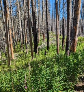
There is a section near the top that was completely burned during the Norse Peak fire in 2017, leaving dead but still standing trees. The multiple blowdowns in this area mentioned in earlier reports are all cleared now. A big Thank You to the clean up crew! And the undergrowth vegetation which had disappeared in the fire is growing back with a vengeance, making this section of the trail really rather pleasant, much prettier than it was 2 years ago when I was last here.
As mentioned in earlier reports, there are 2 big holes, 12’ in diameter or so, in the trail at the top where you turn onto the Ranger Creek Trail. These holes are from uprooted trees. Both are shortly after the junction and can be maneuvered around with caution. Shortly after the holes, there is a large 3-1/2’ in diameter downed tree across the trail. That was a difficult challenge to get past safely. It is on a steep slope, the ground around it is slippery with loose dirt, the bark of the downed tree is slick, and there are no branches coming off it to hold on to. My hiking partner and I were able to help each other over but I am sure it wasn’t pretty. We basically rolled over it on our bellies while holding onto a hiking pole the other was holding out to provide stability so we wouldn’t slide down the hill on the tree. Shortly after clearing that obstacle, there is a group of 3 downed trees across the trail that we easily maneuvered over. There are no further obstacles on the trail for the remainder of the hike.
We arrived back to the parking lot to find the same 2 cars as when we had left and no more. We encountered 5 bikers on the trail and 0 other hikers.
This is a good hike for a hot clear day like today. Most of the hike is up high and/or in the trees making it a cool hike temperature wise. And the multiple views of Rainier, the Crystal Mountain area, and the White River Valley are really quite nice.


Comments