
Road & parking warning- The road in from about Finner Creek Camp is just horrendous. "10 out of 10" for worst forest road to a TH as another seasoned hiker put it. I lost a hubcap somewhere!! (probably in the same road-width puddle I scraped a chunk of bottom plate back on an submerged rock) It took very careful slow driving to get up with just that damage. And then... the mice.
I slept in my car since it's a 4.5 hr drive for me & I wanted to take my time on the trail and get up before a huge crowd. By "slept" I actually mean fought off many mice the ENTIRE night from flooding into the interior but were all over the engine, undercarriage and inner walls. Then had their way with everything chewable as they pooped all over every surface as I camped. So I spent hours decontaminating my care when I got home after an hour of clean up to be able to drive it. Just... ew!
So be warned if you park over night: the trailhead was far worse but parking 1000ft down the road only slightly helped in the long run. They will find any way in after immediately starting exploring your car. May want to spray it down with repellent first, and don't have any food or paper in the car for them to shred for nesting. Maybe it's this time of year, they are super aggressive in food and nest gathering, but I saw several on the drive up scurrying across the road too, so NOWHERE IS SAFE. Wow, really matches the Halloween season. But I would rather have gotten some sleep. Oh well.
The loveliness of the long loop trail (I did counter clockwise which I would opt for again- Up Carne)
FYI- pronounced "Carn", not Spanish for 'meat', which would be odd but also kinda fun. Thanks for that fun fact fellow hiker, I knew it couldn't be "meat".
About the trail, going up Carne Mt was more maintained and smoother trail than the climb up from Phelps River, though Phelps is a nice flatter warm-up for the legs. It's not much more of a climb to top Carne itself, so might as well do that instead of just enjoying the basin where the larches start (which are just past peak now and raining golden leaf-glitter across the landscape in the wind!), or if going on to the passes/high route. The 360 view from Carne is nice, gusty winds when I was there.
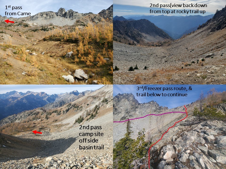
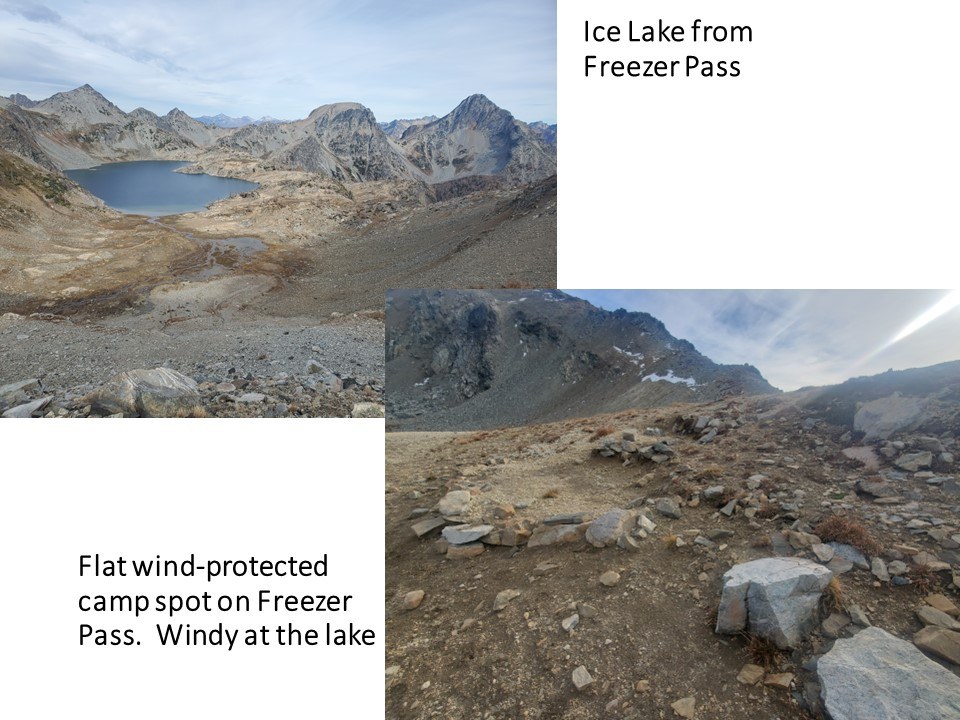
You mount 3 passes to go along the loop and the turn to continue on at Freezer Pass before the Ice lakes is just below the pass, so you don't have to go all the way up it. There are cairns most of the way and a big one at the top on the right a bit at Freezers Pass which drew me to go all the way up which my legs were annoyed at. But honestly, the view down into the rocky basin with stark peaks around Ice Lake is really worth the extra 50' climb. And it let me see where the trail actually goes, a bit down and across the scree field into the larches again.
There are several camp sites along this route, more than indicated on the map. And there was water though low at the various creeks and maybe a spring or two in the valleys. Most only have 1-2 tent spots. The first was indeed the first site on the map with a nice valley view and site up on a mound with trees. After this, the trail to the 1st low pass will turn right just before coming out into an open river valley with a side trail that goes down. Before you get into that opening, loop up slope to the right for some big cairns (plus new orange flagging now). I had to backtrack to find it.
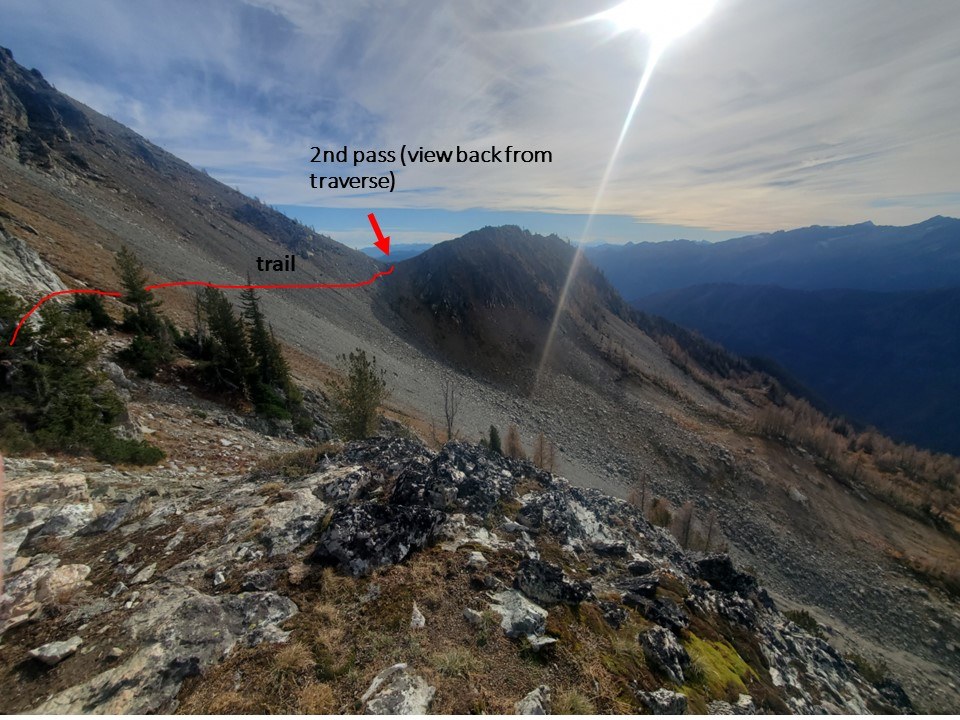
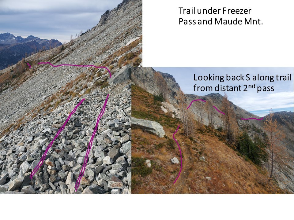
The 2nd pass is a rockier climb to a gentle saddle then mostly straight across scree slope. Looking down to left (west) you will see why there's a side looping trail going down then back up- camp sites! Nice flat larch basin there (see pic). Then you climb up toward Freezer Pass but head more left/west just under the pass with a just visible dimple of trail in the rocky slope and a trail among the first patch of larches again just down a bit in elevation (see pic). If you're legs are dying and you'd like a camp with great views, someone impressively flattened out spots just over the slope of Freezers that's actually sheltered from the gusty wind up there and reportedly at the lakes as well. It's a trek to get water, but may be the less windy spot up there.
Camps: I kept on to camp at the Leroy basin camp in a gorgeous larchy valley with lovely creek and a bit of sunset view. Love the mountain views in this area, with my favorite being unnamed bowl-like mountain just west of Seven Finger Jack- I dub "Dough Punch Mnt" because it looks like bread dough after you punch it down from the first rise. This camp has a nice pit toilet with good sunrise view (fyi). Totally unmarked trails but there's a trail leading from each of the various (and some really nice) camp sites to the toilet and a trail off the main hiking trail, so you'll find it.
Not far below this camp area along Leroy creek there are several small camp sites as well and several scattered along Phelps Creek. It is easy to step over the small creeks that are then along the Phelps Creek trail and crossing Phelps at the intersection with Leroy was fine with some logs that should aid crossing in wetter seasons as well.
I would recommend this loop for any looking for a less trodden but still very doable exploration among beautiful valleys, even when the larches aren't turning for fall. And I loved the very large old-growth specimens of larches that are all over this area. A great population luckily spared from the recent fire across the main river valley. Larches grow in severe habitat and very slowly, so these large ancient trees are a treasure to see.
All in all- terrible road, mice attack, steep rocky strenuous trail, good workout, great views along the whole high traverse, ancient interesting trees, fall colors and nice camps = worth it.
time to order a new hubcap...
Comments