

Wanting to see how work done during WTA work parties several years ago had stood the test of weather and hikers, but not wanting to hike up from Moulton Falls to check out the Sword Fern trail, I decided to try hiking in to it from NE Berry Rd. on BG-2000 and BG-2020. I parked in the clearing by the locked DNR gate across from NE Kaskillah Dr.
Hung my Discover Pass, and set off north, uphill on BG-2000. The gravel road climbs from 1550' to 1900' over about .7 mi, levels out while heading NE, then descends to about 1770' as you pass areas where crews quarried and processed rock into large piles. Had some nice views of clouds partly veiling Silver Star, the Dole Valley, and the Tatoosh Hills along the way, with clearcuts below.
I was watching for a Sword Fern trail sign, but spotted a likely looking path heading off to the North. The tread rapidly degenerated into something barely wider than a dirt bike tire, climbing steeply up through a clearcut. The dog wanted to head back to the car, rebelling against the slippery slope, rocks, and many loose small branches. We continued up. As we entered a Douglas Fir stand about .3 mi up the hill, I recognized an area we had used during a work party to access the Sword Fern trail. The tread suddenly improved, widening, clearing, becoming a pleasure to walk. We continued along familiar, pretty trail. Reached peak altitude 2071' at 1.6 mi into our hike.
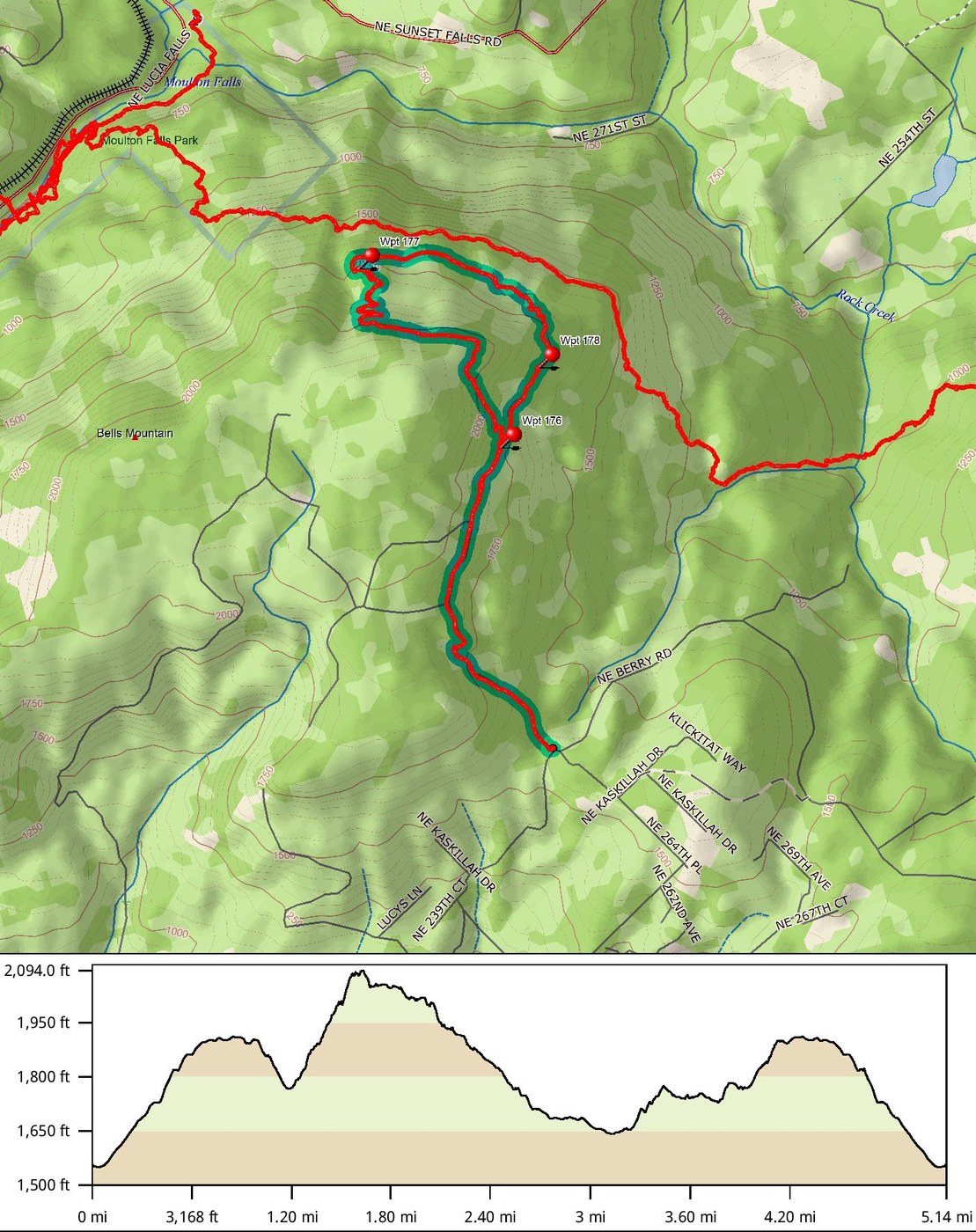
On this stretch, I saw nice trail joining from the east, coming up the hill. We continued on the trail to the NE, then NW, passing an extension which looked like it headed up towards the summit. A series of carefully graded, bike friendly switchbacks lead downhill, eventually emerging on BG-2020 2.6 mi into the hike at 1768'. We'd parked here for many WTA work parties. It was fun to see areas where I'd grubbed out trail, cleared stumps, transplanted ferns, and made drain dips. Log structures others had built to support the tread looked and felt solid. One area could use a little brushing, but the tread was in great shape, well drained, easy to hike. We saw our first Sword Fern Trail signs at that BG-2020 intersection (tagged as Waypoint 177 in the uploaded image).
Since I was familiar with the Bells Mountain trail, I decided to return to the car on BG-2020. The dog, suddenly eager to walk fast, and I headed back to the SE. Saw the only other hiker of the day, a spacey looking young man hiking in the 35F temps wearing a t shirt, jeans and sneakers, without water or any other essentials. The dog, who has been consistently friendly with other hikers on many hikes, growled and barked at him. I held her aside while he passed. He was vague about his direction of travel, unusually energetic, and seemed altered, although not a danger to himself. First time for this sort of encounter in the Yacolt Burn.
3.5 mi into our hike, I saw a second pair of Sword Fern trail signs, one on a a trail coming up to the road from the east, and a second sign on the N side of the road indicating the trail continued up the hill. This is the trail sign I should have hiked in farther to find, and followed. It was 1.6 mi. from the DNR gate, at about N45º 47.827, W122º 24.131, altitude 1740' (tagged in the uploaded jpg as Waypoint 178). Bet this trail has much better tread and routing than the use path we took, and that it leads to the tread I saw joining our route from the east.
We climbed back up to the 1900' top of the road route, then descended to the DNR gate. Total mileage: 5.1


Comments