
After a long, rainy Friday night drive to the south side of Mt St Helens and a short time sleeping and wondering if the rain would stop, we got up at 5 to cloudy skies, had a parking lot breakfast at the June Lake trailhead, and started up at 6:19 AM on our annual epic. We seven were headed for the Loowit Trail #216 and a counterclockwise trip around the mountain in one day. Two guys from Oregon went up ahead of us, to go for clockwise run in 7 hours. We were thinking more like 14-15 hours for 31 miles, hiking and jogging. Weather and conditions were perfect, nice and cool with the sand and ash dampened by a day of rain. At June Lake, 1.7 miles from the TH, we took an unintended detour up the ski route, trail 244, across a lava boulder field heading NW instead of N up through the forest to the Loowit. Retraced and went through the camp site up to the trail. The landscape opens up right away to plains and low growth, with lots of loose sandy gullies to go down and up. Also lots of blue huckleberries at their prime, slowing some of us down a bit to rake off handfuls. A bear had obviously been enjoying the harvest, too, judging from scat on the trail.
Shoestring Glacier drainage was the first really deep gully. One lava boulder field comes early this way, too, with no defined tread. The rough lava is great for traction but can really scrape if you miss a step. This trail might not be enjoyable with a full pack for people not used to climbing or hiking in scree, pumice, sand and boulder fields. We reached Ape Canyon trail 234 at 8:52 AM.
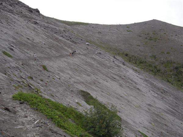
The Plains of Abraham were beautiful, wide open spaces with carpets of yellow green moss some places and lavender blooming sage or little lupine in others. Windy Pass was windy. And cool. 10:11 AM. We stopped for food and needed our windbreakers. After the 95-100 degree days of a couple weeks ago, we were feeling lucky to have the overcast and north breeze, even though the clouds obscured the top of the mountain. This route is totally exposed to weather most of the way.
The route though the Restricted Zone is pretty minimal, sometimes just cairns through rocky, sandy areas with braided shallow streams to jump and more gullies. Lots of scrubby vegetation coming back, with subalpine firs mixed in on north slopes. Some stretches smell like a cattle ranch from the elk. We looked up to the Loowit Falls, but didn’t take the side trip. 10:47 AM. We met the Oregon ultrarun pair just north of here, about 10 miles into it for us and 20 for them right on pace for 7 hours. These were the first people we met on the Loowit.
Spirit Lake was cool to see from this side, and it was really impressive to see the extent of the blast zone. Johnston Observatory came out of the clouds as we went west along the northernmost part of the Loowit. Also saw a couple of black puffs from the crater.
Plenty of water sources this day, but some might not have been there without the rain the day before. We didn’t stop for water but could have at the second large drainage about 2 mi from June Lake Tr 244, and Muddy River and Shoestring Glacier drainage and a couple others, some silty or milky. Most of us started with about 3 liters that took us to a great spring about 1/2 mi past the Windy Ridge trail 216E that feeds a big grove of alders. We took water right from the rocks and skipped the iodine.
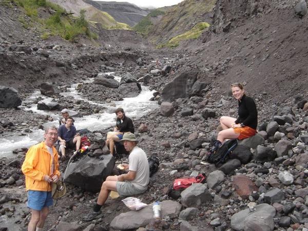
More open territory with little gullies then big gullies then a ridge with kinnikinik above the gorge of the Toutle, and a long, sandy traverse down. After a foot-wetting jump or two across the shallow stream, we took a good break for food and filtered some milky water. 1:30 PM. Met a group of 3 backpackers on the ridge, and 3 day hikers at the river. From here, we went up the long, grown-over forested trail on Crescent Ridge and felt like we were back on the wet side of Washington in typical lush lowland fir-hemlock forest. Some of the tallest red Coral Root orchids I’ve seen. Salmon berries, red huckleberries and blackcaps were ripe. We saw a solitary mountain goat across the valley to the north. This forest changes abruptly when the trail heads south and hits a deep gully that has washed out the trial. At the drainage north of Trial 240 there is a long detour to the west from the route on the Greentrails map, losing maybe 500 VF, then back up the other side. We arrived at Sheep Creek tr 240 at 3:11. From here there’s a dry, open pine forest, smelling great in the afternoon sun. Blue skies now, sun on our backs, and views of the whole mountain here and there. The SW side is a mix of trail and various kinds of rock boulder fields including lava blocks. Butte Creek trail 238A at 4:18 PM, and we met our last 3 hikers in the next stretch when we were feeling like it was coming up on the home stretch. Total of just 11 humans on the loop on a perfect August day! After the Climbers Bivouac trail 216A, the trail goes across some nice open meadows and patches of forest. I flushed a grouse that just about made me jump off the mountain, then disturbed an big doe elk, and met a pica shortly after.
We “decided” to take the lower trail 244, the ski route, back down to June Lake, thus going across the lava field there for the third time today, following the orange poles. Interesting, but a lot easier on skis with a few feet of snow cover. June Lake was a nice, cold place to cool off the hot feet and get washed up before the final 1.7 mi to the cars. Arrived back at the lot feeling really good about the day, after 13 hours, 31.4 trail miles, and 7,447 feet vertical gain. A great dinner at Maria’s Mexican restaurant in Woodland topped it off. Don for Jerry, Kevin, Kristen, Bill, Marc, Matt
Comments