Trip Report
Umtanum Creek Falls, Umtanum Canyon Rim — Monday, Nov. 29, 2004
TUESDAY, NOVEMBER 30, 2004 – UMTANUM FALLS & UMTANUM CANYON RIM
I’ve only gotten in to the upper-most western section of Umtanum Canyon to enjoy Umtanum Creek Falls in the late winter and spring. Thus I was looking forward to seeing how much lower the water in the creek and resulting flow over the falls would be in the fall. So I got on over to the chilly 28 degree temperatures of the region south of Ellensburg and enjoyed spectacular ice and hoar frost/snow formations on the grasses leading the 1.5 miles down the canyon to the falls. The area looked so spectacular here in the cold shade where the sun had not yet melted the snow/frost. Oh, yes, it was pouring heading all the way to the pass, then snowing going over the pass. But I had a full day of sunshine and blue sky to enjoy…albeit cold.
There are many newer posted signs at the one fence that is encountered about ½ mile in on the way in to the falls than anything I’ve ever seen in there…it seems maybe there is the one pocket of the upper canyon that crosses private land which likely is overrun in the highlands with hunters to make the problems worse. While the trail clearly goes down along the creek past the signs…a new trail is forming staying outside of the fence area. While it is only about a five minute hike until you re-cross another fence if you go along the creek, it is still the right thing to do and avoid it to respect the land-owners rights. If they are posting it as heavily as they are, there is likely reason why they do so…unlike 2-4 years of the past where it wasn’t signed so harshly. Be prepared for some real work going around the fence as you climb out of the canyon and back down to do so, following game trails and/or the rough trail that is being used more and more. I find it simpler to stay up on top of the north canyon rim until just before reaching the falls vs. trying to find a way down as soon as you are past the fence…. Call the WDFW office if you want to find out more regarding the most current status of the signs in there.
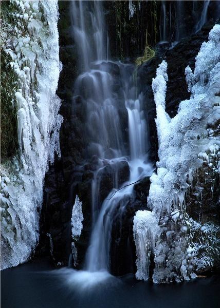
The falls were as spectacular as ever with about ½ the flow as March would show. Ice was forming along the entire creek and falls. What makes the falls so special is the fascinating basalt bowl that they tumble 35-40’ in to. It’s 80% enclosed basalt basin with just a small area open where the creek flows on out eastward on its journey to eventually reach the Yakima River. After a full hour of photography here we scrambled up the very steep south canyon walls and then hiked 3-4 more miles along the south rim/highland areas…fascinating views down the Umtanum Canyon in many areas, continual amazing views of the ribs of Umtanum Ridge to the south…it was so peaceful, quiet, COLD, and lonely. I followed a coyote trail for well over ½ a mile. Many runs of chucker tracks were noted. The hike back out brought out a stunning male ring-necked pheasant. I was amazed to see how different the way out the last 1.5 miles was then when coming in due to the loss of much of the ice crystal formations on the grasses and branches. A stop for excellent food at Rodeo City BBQ in Ellensburg, then it was back home over a much smoother drive over the pass than the snow of the morning. Alan L. Bauer 11/30/04

Comments