The Stossel Creek area in the Marckworth Forest offers some wonderful walking among forest, marshes, and rumpled rocky hills. It's a quiet, little known and visited spot, less than an hour's drive from Seattle. I read about this area in my aging copy of Footsore 2, and it was a pleasant surprise to find the trails and roads still usable twenty years after the publishing of that book.
To get there, drive to Carnation or Duvall. From Duvall, drive south on SR 203; from Carnation drive north on SR203. At Stillwater Store, turn onto Kelly Road, passing major junctions with Big Rock Road and Lake Joy Road. Turn right onto Stossel Creek Way. At the Markworth Forest sign, the road turns to dirt. Continue a mile farther. Just beyond the point where the road crosses through a narrow gap in a ridge, gated logging roads roads head right and left. Park on the right hand road (south). The elevation is about 600'--you won't have much of a problem with winter snow here.
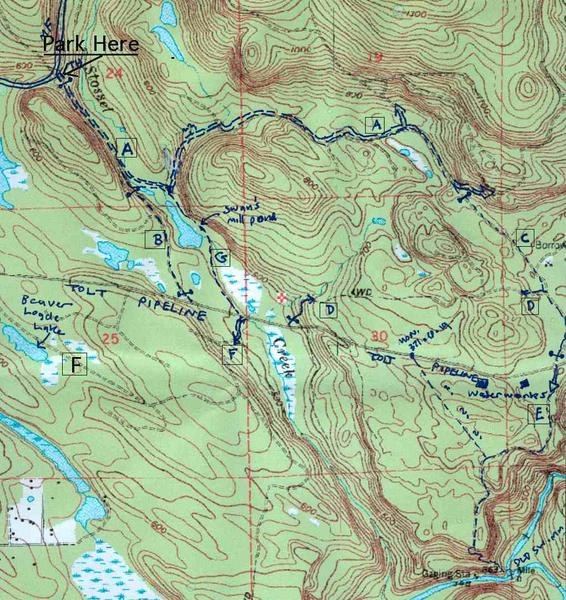
From the parking area, walk pass the gate and follow the logging road down into the valley of Stossel Creek. The logging road appears to be well used, although I didn't see any activity on the Saturday when I walked it. Be prepared for log trucks if you come weekdays. On the attached map, this road is referred to as road ""A"". The Stossel Creek valley is forested and peaceful, the only sound being the soft rush of the creek below. Birds love the wetlands along the floor of the valley--I saw a number of large hawks circling above. In a half mile the road crosses the creek (elev. 500') and after a short distance begins a steep climb out of the valley.
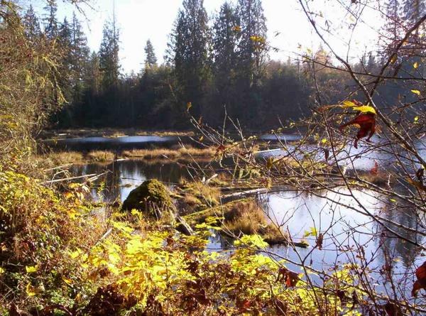
Just before the climb, note a path branching right and heading south along the valley floor. This path ( ""G"" on the map) is well worth following. It's an old road that has decayed into a footpath. The path soon reaches the placid waters of Swan's Mill Pond, and follows the east shore. The path passes two old shot-up old cars, then reaches a lovely flat area on the shore of the pond, next to a jumble of mossy boulders. On a clear day, the lake reflects the low winter sun onto this spot, creating a pleasant oasis of warmth. What a perfect spot for a picnic! From here,the path continues heading south to the old dam that forms the lake, then crosses the creek. At high water, this crossing can be tricky: you have a choice of wading the creek or scrambling across a jumble of wet, slimy logs. If you do make it across, the path reaches the Tolt Pipeline Trail after 1/3 mile.
Instead of crossing the creek, you may choose to return to road A and follow it out of Stossel Creek valley. This road gradually climbs up a quiet side-valley, passing through logged forest in various states of regrowth. Some recently logged areas are visible, but these are generally tastefully-done selective cuts that aren't too ugly. After a long mile from Stossel Creek, the road reaches a high point (750') and a junction. Leave the main road here, and follow a gated, little-travelled road (road ""C"" on the map) southward. This road's mossy surface is pleasant to walk on. It gradually descends to a junction with the Tolt Pipeline Trail in a short mile. Along the way, you get glimpses of snowy Cascade peaks. Just before the Tolt Pipeline junction, overgrown-looking road ""D"" branches right. If you are adventurous, you might try hiking road D instead of slogging along the Tolt Pipeline Trail. I didn't check it out.
Beyond The Tolt Pipeline is the start of Road E, next to a chain link fence. This road may take you to the ""Old Swimming Hole"" on the Tolt River. Alas, I didn't have time to check this route out, either.
The Tolt Pipeline Trail extends for miles, and comprises a grassy strip and narrow paved road occupying a wide swath in the forest. A wood fence separates the grass area from the road. Hikers are supposed to walk on the grass and stay off the road; however, the grass frequently is lumpy and muddy, so you will be tempted to walk on the road anyway. Traffic on the road is almost nil on weekends (only service vehicles with permits can use it), so there seems to be little risk in doing so.
If you head east on the Tolt trail, in a mile you will reach a bridge over the Tolt River. Supposedly, there is a dramatic gorge to look at here, but I haven't checked this out. Beyond the gorge, the pipeline corridor is not open to the public. Heading west, the Tolt Pipeline trail will take you back in a mile to Stossel Creek, the path dropping steeply as the valley is approached. As you slog along this rather boring route, try to figure out how many forests were sacrificed to produce that endless wood fence! A large marsh occupies the floor of the Stossel Creek valley, another great bird watching area. Just beyond the marsh, look for the start of trail G on the north side, marked by a trampled path heading up a bank, a blue ribbon, and some boulders. This will take you back to Swan's Mill Pond and your car.
Across the Tolt Pipeline Trail from Trail G is the start of Road F, which provides more hiking possibilities which I haven't checked out. One branch of this road passes Beaver Lodge Lake before rejoining the Tolt Pipeline about one mile west of this point. Give it a try!
An alternative route back to your car is road B, reached by continuing west along the Tolt Pipeline another quarter mile. Road B is gated and little used, a very nice walking route. It joins Road A upstream of Swan's Mill Pond, from where it is a short walk back to your car.


Comments