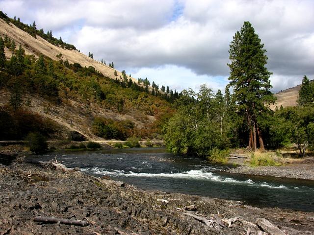

Walk pleasantly beside the nationally-designated Wild and Scenic Klickitat River along the old railroad bed that once went from the Columbia River town of Lyle to Goldendale. Enjoy the golden hills, the swift-flowing river that is a favorite of kayakers and spring wildflowers that begin bursting forth as early as February.
This first section of the 31-mile Klickitat Trail is a rails-to-trails conversion from Lyle to Warwick (on the Lyle-Centerville Highway), with several access points along the way. The Klickitat River section runs 10 miles upriver from Lyle to the hamlet of Pitt paralleling the river the entire way. This is a multi-use trail, so expect to see bicyclists and equestrians along the way. Also, due to its proximity to private land, please stay to the trail, obey all signs and keep dogs leashed.
From the new trailhead in Lyle, the first 1.6 miles to the Fisher Hill Bridge are easy walking on a compact gravel trail. Take time to admire the new decking on the railway trestle. After the Fisher Hill Bridge, hikers embark on the more wild section of the trail. State Route 142 also parallels the river on the opposite side, but it is a fairly quiet stretch of road and does not impede on your hike too much. Instead, watch for kayakers maneuvering through the whitewater below. If you have only one car, find a nice place to lunch in this stretch and return to Lyle.
If you have two cars, you'll want to do this as a one-way trip - and even better in reverse, going downstream from Pitt to Lyle. As you near Pitt, the trail gets closer to the river again. Houses appear on both sides of the river. Eventually you'll pop out. Cross the highway to a small parking lot with a privy.
The Klickitat Trail continues until a major bridge wash-out just east of the town of Klickitat. It then picks up again on the other side - a fabulous section through Swale Canyon. This trail is a partnership between the Klickitat Trail Conservancy, Washington State Parks and the US Forest Service.
Klickitat Rail Trail - Klickitat River

-
 Length
- 10.5 miles, roundtrip
-
 Elevation Gain
- 200 feet
-
 Highest Point
- 350 feet
The Klickitat Trail is a 31-mile rails-to-trails conversion managed by Columbia Hills State Park. This linear park goes from Lyle to Warwick (on the Lyle-Centerville Highway) with several access points along the way. This Hiking Guide entry describes the route between Lyle and Pitt Road.
Continue reading
Hiking Klickitat Rail Trail - Klickitat River
Wheelchair Accessibility
The Klickitat Rail Trail is a firmly-packed gravel route about 5-8 feet wide.
WTA worked here in 2017, 2016, 2015 and 2014!
Klickitat Rail Trail - Klickitat River
Map & Directions
 Trailhead
Before You Go
Parking Pass/Entry Fee
NoneWTA Pro Tip: Save a copy of our directions before you leave! App-based driving directions aren't always accurate and data connections may be unreliable as you drive to the trailhead.


