

Acquired in four phases through Spokane County’s Conservation Futures Program, with additional funding secured through the Washington State Recreation and Conservation Office, the Antoine Peak Conservation Area consists of 1296 acres of conservation land and offers fantastic views overlooking Liberty Lake, the Spokane Valley, and north to Mount Spokane and the Selkirk Range. The trail system consists of old logging roads converted to trails and newly constructed single track.
Demonstrating the Conservation Futures Program’s commitment to benefiting wildlife, conserving natural resources, and improving opportunities for passive recreation in Spokane County, the Conservation Area is home to numerous wildlife and plant species. Hikers, snowshoers, skiers, birders, mountain bikers and equestrian users alike could potentially spot red-tail hawk soaring overhead, listen to pileated woodpeckers at work on surrounding trees, come across signs of the resident white-tailed deer, moose, and elk populations, or spot such locally rare trees as Pacific yew.
Through additions and improvements over the years, there are now three different access points for the trail network on Antoine Peak. The west side access at Brevier Road offers the most direct route to the summit of Antione Peak, as well as the quickest connection to the Emerald Necklace route that travels around the base of the peak at approximately the 3000-foot level. This access point offers the best views of the Spokane Valley. From the trailhead visitors can choose to follow either the communications tower access road in the trees or a single-track trail crisscrossing a west-facing meadow as it climbs for just under a mile to an overlook. Royal Riblet’s Mansion, home of Arbor Crest Winery, is visible on the cliff overlooking the Spokane River to the southwest; Peone Prairie and its checkerboard of agricultural land lies to the northwest.
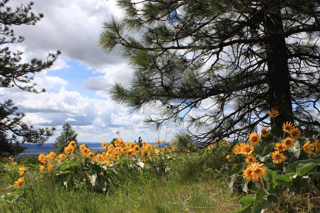
Continue up trail to the first intersection and veer right for the Emerald Necklace loop, for a total of just over five miles round-trip and views of the east Spokane Valley all the way to Liberty Lake. The west side of the mountain is transformed into a sea of gold in the early spring, when arrowleaf balsamroot cover the hillsides on this generally dry side of the mountain. Adjacent to the trail, watch for rocky mountain junipers popping up among the larger Ponderosa pines and fir trees.
For those who would prefer to summit rather than take the round-the-mountain route, veer left at the intersection and continue uphill just under half a mile along the old roadbed that also accesses the communications towers on the summit.
At the second intersection, turn right and continue uphill for a half-mile to the summit; the left- hand trail is the return route for the Emerald Necklace loop. This route is also frequently traveled by workers accessing the communication towers at the summit, so watch for vehicles along the way.
For those who access the property from the east at Canfield Gulch off Lincoln Road, the options consist of a longer, more gradual ascent via an old logging road converted to trail, or a slightly steeper single track option. Both connect to the Emerald Necklace at a main intersection, and then continue to ascend via single track to the summit of Antoine Peak.
The old logging road option that leads northwest from the parking area passes Leland Pond enroute, offering the best chance for spotting a moose. The trails on this side of the peak follow the small streams that feed the pond, where hikers can view rare Pacific yew trees. Increased moisture on this side of the mountain yields increased diversity in plant life. In the spring, watch for trillium and shooting stars along seasonal seeps, giving way to lupine blooms and Indian paintbrush later in the season.
The most recent addition to the Conservation Area is the Etter Ranch property, with a trailhead located in the Spokane Valley at Wellesley and Flora. Acquired in 2019 with the trailhead opening in 2021, trails here are still under construction. The completed Arrowleaf Trail is the main connector leading to the Emerald Necklace, with nearby Lost Apple Trail serving as a shorter and lower elevation option.

 Trailhead


