
Coal Creek Falls is a wonderful destination for any day hiker looking for an easy, family-friendly trail with a picturesque culmination at Coal Creek Falls. It’s a well maintained trail that meanders beneath a thick canopy of maple, alder, and cedar trees and between a dense understory of salmonberry, ferns, and numerous wildflower species in the spring.
The popular trailhead is located in the Cougar Mountain Regional Wildlife Park. There is a veritable maze of trails and trailheads here so it is helpful to bring along a map of the area.
Cougar Mountain was extremely busy with coal mining from 1863-1963. The miners tunneled six miles under the mountain and strip mined the surface, eventually hauling out 11 million tons of bituminous coal. Remnants of the mining past are obvious when you see the large holes in the ground alongside the trail. These “cave holes” were formed when miner’s underground extractions got too close to the surface, which eventually led to cave-ins. Be sure to stay on the trail so as to avoid the deeper and potentially dangerous cave holes. One of the larger holes in the area is rumored to go 518 feet below sea level.
The forest endured logging in the past and there are some pretty remarkably large stumps left behind to remind you of what was once there. There is a fair amount of stinging nettle edging the trail, so be sure to stay on the marked route!
From the trailhead veer left following the Red Town Trail. The trail starts off very wide. At the first trail junction, 0.1 miles in, veer left, joining the Cave Hole Trail. The trail gets a bit narrower here but it is still wide enough for vehicles.
After 0.2 miles along the Cave Hole Trail, you will encounter another trail junction, continue along the Cave Hole Trail for an additional 0.4 miles where you will reach your third trail junction. Here, veer to the right to begin along the Coal Creek Falls Trail. The trail becomes much more narrow here.
This trail used to be notorious for its muddy conditions but thanks to a reroute completed by WTA in 2014 your shoes should stay relatively clean. As the trail begins to descend you should hear the sound of running water from nearby Coal Creek.
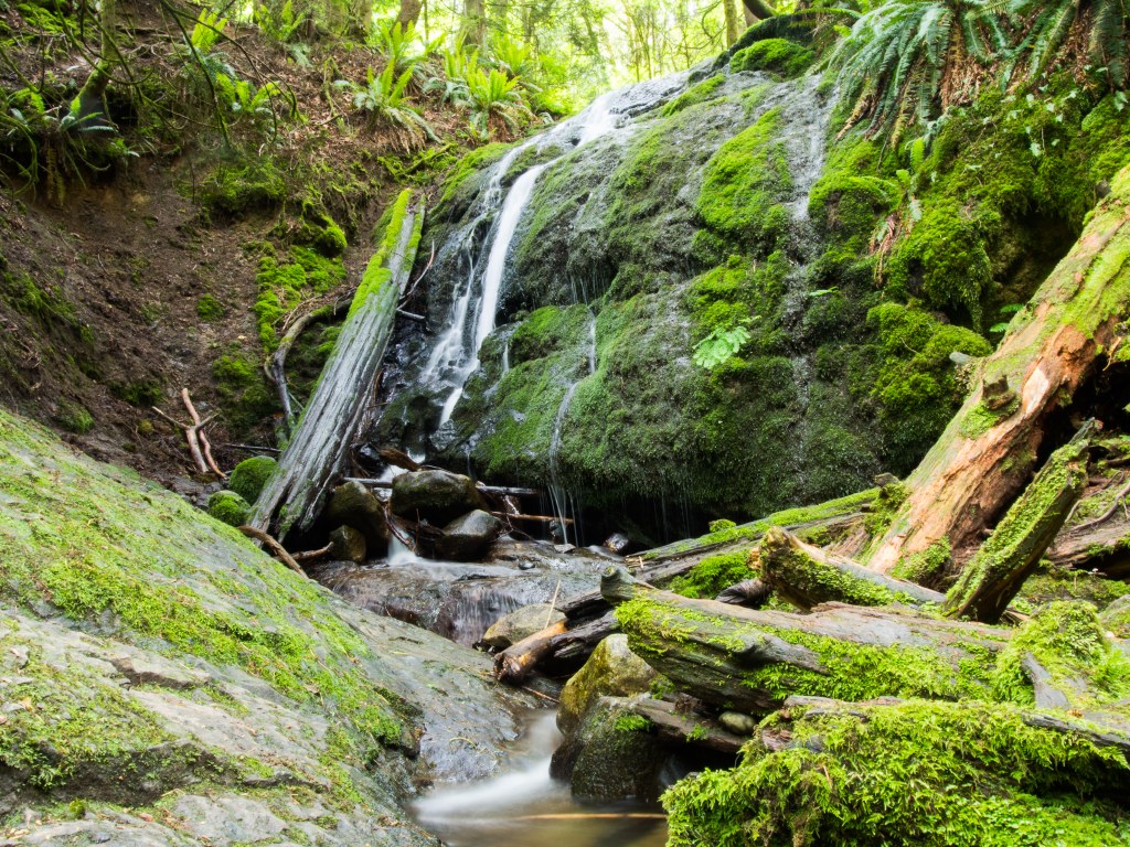
After a short set of stairs going down it’s just 0.3 miles further and you reach Coal Creek Falls! This 28 foot waterfall is fueled by runoff and has its best flows in the rainy, winter months. The falls do run dry during the summer months, usually mid June to whenever the rainy season starts up again in the winter.
There is a large parking lot at the trailhead, but it’s heavily used and fills up quickly. The trailhead is equipped with two privies, garbage cans, a picnic table, historical interpretive signage, and doggie bag dispenser.
Coal Creek Falls

-
 Length
- 2.5 miles, roundtrip
-
 Elevation Gain
- 416 feet
-
 Highest Point
- 1,066 feet
Coal Creek Falls is a wonderful destination for any day hiker looking for an easy and/or family friendly trail with a picturesque culmination at Coal Creek Falls. It’s a well maintained trail that meanders beneath a thick canopy and a dense understory with many wildflower species in the spring.
Continue reading
Hiking Coal Creek Falls
Map & Directions
 Trailhead
Before You Go
Parking Pass/Entry Fee
NoneWTA Pro Tip: Save a copy of our directions before you leave! App-based driving directions aren't always accurate and data connections may be unreliable as you drive to the trailhead.
Getting There
From Seattle head east on I-90. Take exit 13, West Lake Sammamish/SE Newport Way, turn right at the end of the exit ramp onto Lakemont Boulevard. After one mile continue straight through the stoplight. The trailhead is on the left (east) side of the road after an additional 1.8 miles along Lakemont Boulevard which turns into Newcastle-Coal Creek Road. The turnoff for the trail is located along a sharp bend in the road. There is a large blue King County sign that is hard to miss at the entrance.