
Dock Butte boasts sweeping views of Mount Baker, Baker Lake, and several prominent peaks in the North Cascades and Olympic Peninsula. It is a great option for beginner hikers looking to up their hiking game as well as those looking for exceptional mountain views without the mileage and time commitment of a longer hike.
Starting at the shared trailhead for Blue Lake Trail 604, head into the forest teeming with pacific silver fir, subalpine fir, and mountain hemlock. The trail is straightforward and easy to follow— clear dirt paths alternate with more eroded and rubbled sections. Partridgefoot, a fanciful semi-shrub that looks a bit like parsley, peeks up from the ground, as well as deer fern and haircap moss.
In about a quarter mile, come to a signed intersection that splits left for Blue Lake and right for Dock Butte. Head right towards Dock Butte and continue climbing upwards through a particularly rocky patch of trail to your reward: Mount Baker peeking through the trees— just a taste of the views to come.
Continuing on, pause as each small break in the forest reveals clearer and clearer views of Mount Baker and her subpeaks: Colfax Peak and Lincoln Peak. Gradually emerge into open, grassy meadows with small tarns dotting the way. Spot Sitka mountain-ash, a deciduous plant whose jagged-edged leaves turn a bright magenta, orange, and yellow in the fall.
At about the 2.0 mile mark, the trail forks. To your left is a direct scramble route to the summit, and to the right is a milder trail that gently switchbacks up the northern side of Dock Butte. Either trail will get you there; it’s your preference which one to take. The milder trail rejoins the scramble route just below the summit.
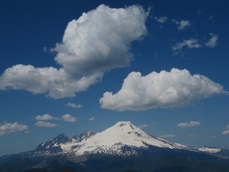
The 360 degree views from the summit of Dock Butte are simply spectacular. Mount Baker is the brightest star in a constellation of peaks visible to you on a clear day, including Mount Shuksan, Glacier Peak, Sloan Peak, Whitehorse Mountain, Three Fingers, Mount Rainier, Mount Angeles, Hurricane Hill, Twin Sisters, and Loomis Mountain. The clear, turquoise waters of Baker Lake stretch out to the east, as well as the verdant Skagit Valley to the south. Enjoy your lunch or snack in the company of these fine landmarks, and marvel at how a fire lookout, built in the mid-1930s, once stood in this very spot until the early 1960s.
WTA Pro Tip: Even though the trail is relatively short, pack hiking poles, sun protection, and plenty of water. The trail is a bit roughed-up in stretches and poles will help navigate these areas. It is also very exposed the last mile to the summit, so a hat and sunscreen will come in handy as well as plenty of water.
Extend Your Hike: Make your hike a two-for-one by checking out Blue Lake on your way back to the trailhead. From the Blue Lake / Dock Butte sign, follow the arrow towards Blue Lake for a little over a half mile until you reach the lake.
Dock Butte

-
 Length
- 4.4 miles, roundtrip
-
 Elevation Gain
- 1,500 feet
The trailhead is inaccessible until further notice due to FR 12 closure.
Parking Pass/Entry Fee
Northwest Forest Pass
Dock Butte boasts sweeping views of Mount Baker, Baker Lake, and several prominent peaks in the North Cascades and Olympic Peninsula. It is a great option for beginner hikers looking to up their hiking game as well as those looking for exceptional mountain views without the mileage and time commitment of a longer hike.
Continue reading
Hiking Dock Butte
Map & Directions
 Trailhead
Before You Go
The trailhead is inaccessible until further notice due to FR 12 closure.
Parking Pass/Entry Fee
Northwest Forest PassWTA Pro Tip: Save a copy of our directions before you leave! App-based driving directions aren't always accurate and data connections may be unreliable as you drive to the trailhead.
Getting There
Take I-5 to exit 230 for Highway 20 East. Continue for 22.5 miles, following the signs for Highway 20 East. About 0.15 miles past a brown sign for Baker Lake Sno Park, turn left onto signed Baker Lake Road (Forest Road 11).
Continue for 12 miles on Baker Lake Road. Just past Rocky Creek Bridge, turn left onto unsigned Forest Road 12. Continue on Forest Road 12 for 3.5 miles. Reach a junction and continue straight, following the sign for Blue Lake. After another 3.2 miles, turn left at the sign for Blue Lake onto Forest Road 1230. Continue on Forest Road 1230 for 3.6 miles, staying on the main road and ignoring the roads on your left until you arrive at the trailhead and parking lot. There is room for roughly 15 cars and there is a vault toilet at the trailhead.


