Trails for everyone, forever

Home Go Hiking Hiking Guide Nason Ridge

Nason Ridge

Central Cascades > Stevens Pass - East
47.7882, -120.7923 Map & Directions
Length
21.9 miles, roundtrip
Elevation Gain
3,800 feet
Highest Point
6,200 feet
Calculated Difficulty About Calculated Difficulty
Hard
A small seat near the lookout, overlooking the lake. Photo by Zipster. Full-size image
  • Dogs allowed on leash
  • Ridges/passes
  • Summits

Parking Pass/Entry Fee

None
Saved to My Backpack

Hike a trail that traverses Nason Ridge. Along the way, you'll enjoy panoramic views of the surrounding summits, as well as access to an old fire lookout. Continue reading

Rating
3.75 out of 5

(8 votes) Log in to rate

Hiking Nason Ridge

Starting at Snowy Creek, you’ll climb quickly out of deep old-growth into"Hills Are Alive" scenery: think expansive, flower-studded meadows on steep mountain slopes and 360-degree views of peaks from Mount Daniel to Glacier Peak.

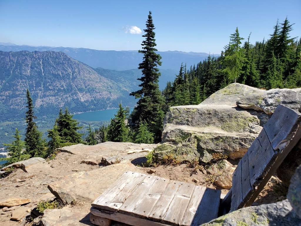
4 miles in, after 1300 feet of gain, you hit the first landmark, the old Rock Mountain lookout site, a great lunch spot or turnaround point for a day hike. You can see Rock Lake below you. Rock Lake has some pleasant campsites, or you can press on another 1.3 miles and camp at Crescent Lake. 

Between Rock and Crescent is where you’ll encounter the sketchiest sections of trail–some steep sidehill stretches that have severely eroded and don’t have much solid tread remaining. Try not to get too distracted by the views so that you can step carefully through here.

The Merritt Lake junction comes about 3.5 miles beyond Crescent Lake. Here you can take a right to descend to the Merritt Lake trailhead for the 12-mile version of the hike, or a left to stay on the Nason Ridge Trail.

Merritt Lake has a big camp with a privy, but the bugs can be brutal here in June. From Merritt, it’s a half-mile side trip up and over the other side of the ridge to Lost Lake. 

It’s another three miles from Merritt Lake to the Alpine Lookout, which was staffed up until recently.

There’s still a structure here and great views of Lake Wenatchee and Dirtyface Mountain. Another good lunch spot–just remember there’s no water. And then from there it’s 4.5 miles downhill on good trail to the Round Mountain trailhead.

Traveling further

The easternmost nine miles of the trail, from Lake Wenatchee to Alpine Lookout, are open to motorized travel and generally in good shape.

To experience the more rugged part of Nason Ridge, I recommend a thru-hike starting from the Snowy Creek trailhead at Stevens Pass and ending at either Merritt Lake or Round Mountain. Snowy Creek to Round Mountain is 17.5 miles, which you can shorten to 12 miles by exiting via the Merritt Lake trail instead.

Either way you’re looking at a good two-day backpack or an epic day hike. Note that water can be scarce throughout, and nonexistent east of Merritt Lake. 

Toilet Information

  • No toilet at trailhead

More information about toilets

Hike Description Written by
Claire Thompson, WTA Staff

Nason Ridge

Map & Directions

Trailhead
Co-ordinates: 47.7882, -120.7923 Open in Google Maps

Before You Go

See weather forecast

Parking Pass/Entry Fee

None

WTA Pro Tip: Save a copy of our directions before you leave! App-based driving directions aren't always accurate and data connections may be unreliable as you drive to the trailhead.

Getting There

Drive east on Highway 2 58 miles to Stevens Pass. Go through Stevens Pass and down the other side to the Smithbrook trailhead, found 3.5 miles east of the pass. Just as the highway divides, there is a left turn for FR 6700. Be cautious crossing the westbound lanes of Highway 2.

If you are coming from the east side of the Cascades, drive 31 miles west of Leavenworth and turn right onto FR 6700

Head for the Lake Valhalla trailhead, which is 2.5 miles up FR 6700. Proceed a mile past this, and arrive at Rainy Pass, where there is a small pond and a sign for the Nason Ridge Trail. Continue another mile to the junction with the Snowy Creek Road, turn right, and drive for 4 miles. The trailhead is 8.5 miles from the junction with Highway 2.

FS 6700 is well-maintained. The Snowy Creek road is brushy, but the road surface is typically driveable with two-wheel drive.

Alternate Trailheads

You can also access this trail from Round Mountain, Snowy Creek, Rock Mountain, or Merritt Lake. Note that access via Rock Mountain or Snowy Creek trailheads will have very limited parking.

More Hike Details

Trailhead

Central Cascades > Stevens Pass - East

Nason Ridge (#1583)

Okanogan-Wenatchee National Forest, Wenatchee River Ranger District

Guidebooks & Maps

Green Trails No 146 Plain

Green Trails No 145 Wenatchee Lake

Green Trails No 144 Benchmark

USGS Plain/Lake Wenatchee/Mount Howard/Labyrinth Mountain

Buy the Green Trails Plain No. 146 map

Buy the Green Trails Wenatchee Lake No. 145 map

Buy the Green Trails Benchmark Mtn No. 144 map

You can improve or add to this guidebook entry!

Nason Ridge

150 Trip Reports

Hiked here recently?

Submit a trip report!
 
Trip Reports