Trails for everyone, forever

Home Go Hiking Hiking Guide Pacific Crest Trail (PCT) Section K - Stevens Pass to Rainy Pass

Pacific Crest Trail (PCT) Section K - Stevens Pass to Rainy Pass

Central Cascades > Stevens Pass - East
47.7460, -121.0892 Map & Directions
Length
117.0 miles, one-way
Elevation Gain
26,351 feet
Highest Point
6,600 feet
Calculated Difficulty About Calculated Difficulty
Hard
  • Wildflowers/Meadows
  • Ridges/passes
  • Wildlife
  • Established campsites
  • Mountain views
  • Summits
  • Rivers

Parking Pass/Entry Fee

Northwest Forest Pass
Saved to My Backpack

By far the most difficult stretch of PCT in Washington, Section K puts hikers through a grueling 127-mile trek over harsh terrain and treacherous conditions. Yet those intrepid enough to attempt it are rewarded with a true wilderness experience in and among some of the country's most pristine and beautiful surroundings. Continue reading

Rating
4.25 out of 5

(8 votes) Log in to rate

Hiking Pacific Crest Trail (PCT) Section K - Stevens Pass to Rainy Pass

By far the most difficult stretch of PCT in Washington, Section K puts hikers through a grueling 127-mile trek over harsh terrain and treacherous conditions. Yet those intrepid enough to attempt it are rewarded with a true wilderness experience in and among some of the country's most pristine and beautiful surroundings. 

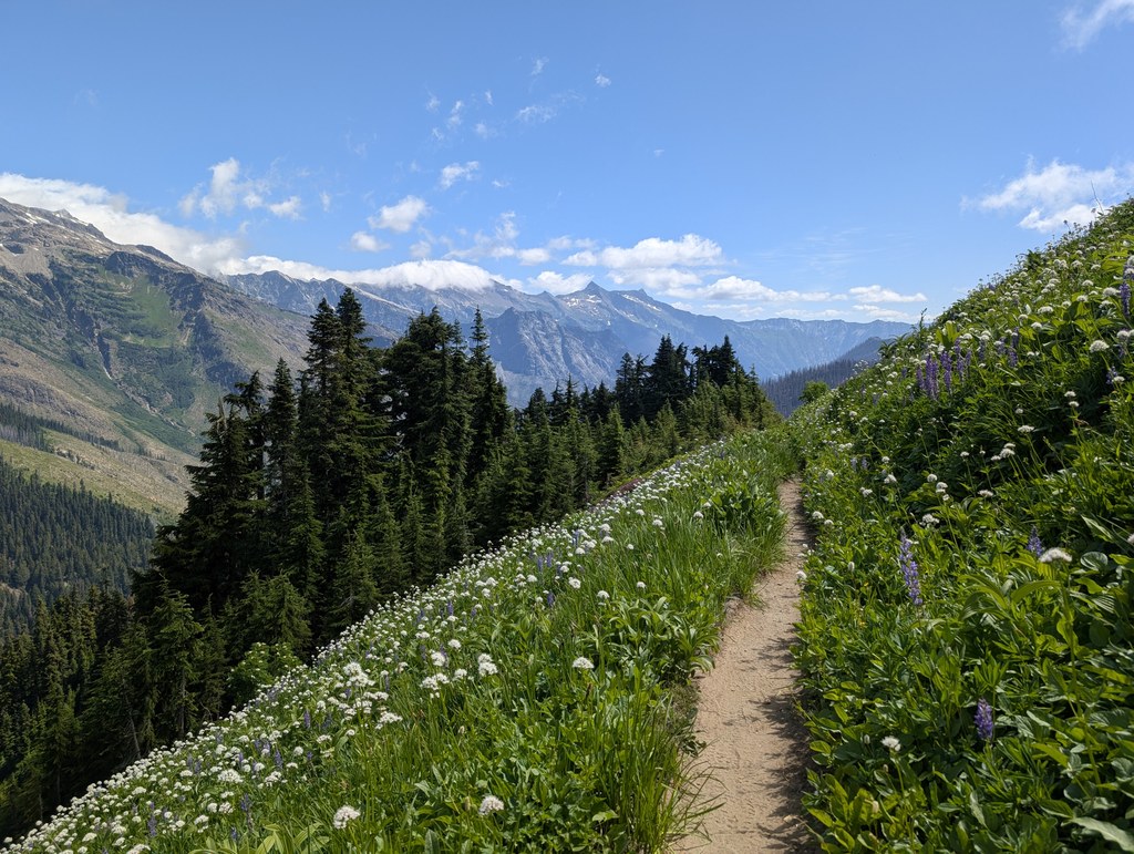
There's no two ways about it: Section K is tough. In fact, only California's infamous John Muir Trail section is considered more challenging on this iconic trail. But for those with the skills and desire, the hike from Stevens Pass to Rainy Pass is also one of the PCT's most rewarding. Wild, rugged and stunning, this section passes through two wilderness areas and a National Park, allowing hikers to experience the natural beauty of the Pacific Northwest untarnished by civilization.

Stevens Pass offers day-hikers and backpackers a good starting point, and thru-hikers can stop here (or head to a nearby town) for supplies. From here, you're on your own as the PCT heads deep into the North Cascades. Expect a lot a climbing, and a lot of descending: there's 26,351 feet of gain, as well as 25,552 feet of elevation loss along this section. The truly breathtaking section is where the trail winds northward up and down the mountains, valleys and canyons of the Glacier Peak Wilderness. Be sure to take plenty of breaks, both to catch your breath and to take in the glorious surroundings, which include views of dozens of peaks, glaciers, mountain lakes and alpine meadows.

Summer and early fall are the best times to hike this section, as thick snow-pack, treacherous river crossings and high avalanche danger often make it impassable through mid-summer. No matter when you hike it, be sure to check current conditions before heading out so you're abreast of any bridge outings or hazardous conditions.

Be aware that old maps might show a river crossing of the Suiattle River near Miners Creek. That bridge washed out many years ago. The trail has been re-routed to cross the Suiattle River on a lovely bridge a few miles downstream.

Water is plentiful on this section, but thru-hikers and backpackers should be sure to pack everything they need for the journey, as the only available supply stop after Stevens Pass is via a National Park Service shuttle in Stehekin, around the 100-mile mark. Bears are common here, so either hang your food or bring bearproof canisters for storing food overnight.

WTA worked here in 2015!

Hike Description Written by
Multiple authors contributed to this report, WTA Community

Pacific Crest Trail (PCT) Section K - Stevens Pass to Rainy Pass

Map & Directions

Trailhead
Co-ordinates: 47.7460, -121.0892 Open in Google Maps

Before You Go

Equestrian Detour - A temporary hiker-only bridge has been installed across Bridge Creek near North Fork camp. Horseback riders will need to detour around this bridge.

See weather forecast

Parking Pass/Entry Fee

Northwest Forest Pass

WTA Pro Tip: Save a copy of our directions before you leave! App-based driving directions aren't always accurate and data connections may be unreliable as you drive to the trailhead.

Getting There

From Seattle, drive east on Highway 2 to Stevens Pass (65 miles from the beginning of Highway 2 in Everett). Drive under the pedestrian overpass and turn left into the large parking lot on the north side of the pass. Park here, being careful not to block in other cars or block driveways or access roads.

From Leavenworth, drive to Stevens Pass. Just before the pedestrian overpass, turn right into the large parking lot on the north side of the pass. Park here, being careful not to block in other cars or block driveways or access roads.

The trailhead is located at the northernmost corner of the large parking lot (in the back corner at the end farthest from the pedestrian overpass).

Take Transit

Take the bus to the trailhead! Plan your trip by bus using TOTAGO.

More Hike Details

Trailhead

Central Cascades > Stevens Pass - East

Pacific Crest Trail Section K - Stevens Pass to Rainy Pass (#2000)

Mt. Baker-Snoqualmie National Forest, Okanagon-Wenatchee National Forest

Guidebooks & Maps

Pacific Crest Trail Oregon & Washington (Jeffrey Schaffer and Andy Selters) - Wilderness Press

Pacific Crest National Scenic Trail

Cascade Series - Northern Washington

http://www.pctmap.net/maps/

You can improve or add to this guidebook entry!

Pacific Crest Trail (PCT) Section K - Stevens Pass to Rainy Pass

194 Trip Reports

Hiked here recently?

Submit a trip report!
 
Trip Reports