How to Get to King County Trailheads Without a Car
Get to parks, trails and green spaces in King County using these public transportation routes.
Getting outside is important for people’s hearts, minds and bodies. Access to nature and the opportunity to safely experience parks, open space and nearby public lands is a right everyone should enjoy.
But even in an evergreen state like Washington, opportunity doesn’t always mean access.
King County is home to over 2 million people. It’s the most densely populated part of the state. In the county, however, access to the outdoors is strongly dependent upon where you live. According to a report by The Wilderness Society, 88% of Seattle residents have a park within a half-mile of home. Outside of Seattle, only 45% of residents do so, with particularly large gaps in south King County.
At WTA, we believe everyone should be able to enjoy the vast benefits of greenspaces. It’s why we’re working in places like unincorporated North Highline, building trails and engaging neighbors, to bring nearby access to the outdoors. Our partners across King County — like King County Parks and Recreation, The Wilderness Society and the Environmental Coalition of South Seattle (ECOSS) — care about access to the outdoors, too. One way we want to ensure folks in King County can enjoy getting outside is supporting transportation that gets them to these places.
get outside without a car
So how does someone get from their home to the trail if they don’t have access to a personal vehicle? We’re here to share some alternative ways to visit parks, trailheads, and public lands using public transportation!
Now that Trailhead Direct is over for the season, it’s a good time to remind folks in King County that there are other ways to get to green space if you don’t own or would prefer to not use a car. Here are a few of the routes you can try.

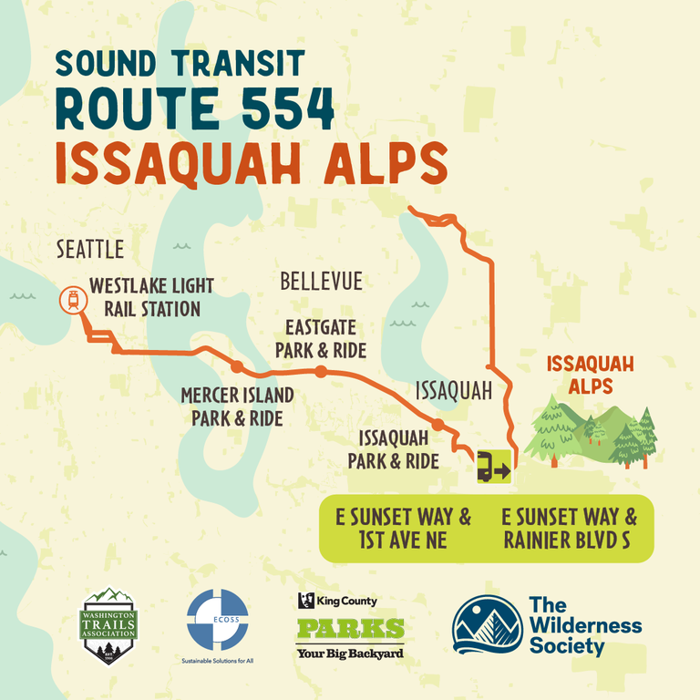
Ride Sound Transit 554 to hike The Issaquah Alps
The Issaquah Alps are a series of mountains near the city of Issaquah including Cougar Mountain, Squak Mountain, Tiger Mountain, Taylor Mountain, Rattlesnake Ridge and more. These mountains offer an impressive variety of ways to explore, such as finding water on the Tradition Lake Loop, paragliding near Poo Poo Point or watching a waterfall at Coal Creek Falls. The hiking opportunities range from a family-friendly picnic to a tough conditioning route for folks training for an intense trip. WTA’s Hiking Guide allows you to sort through the 170+ park and trail options in this area.
Sound Transit 554 goes to downtown Seattle, the Mercer Island Park and Ride, the Bellevue Park and Ride, and then through Issaquah and Sammamish before a final stop in Redmond. With this route stopping at multiple different park and ride stations, there are plenty of places to catch this bus. Stops near the Issaquah Alps on the ST 554 involve traveling between 0.2 to 0.8 mile distances to access multiple trails at Tiger Mountain and Squak Mountain. ST 554 operates a bus that stops near these Issaquah Alps trails all days of the week.

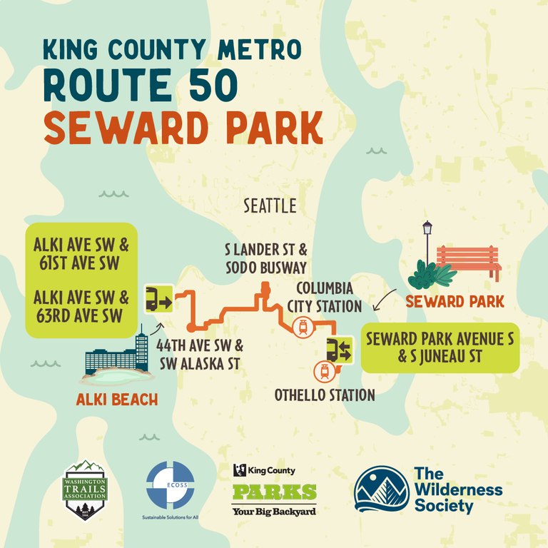
RIDE King County Metro 50 to Seward Park
Seward Park is a peninsula at the south end of Lake Washington, just south of Seattle’s Columbia City neighborhood. The park is 300 acres of forested land with Lake Washington shoreline at the edges. The park offers opportunities to take a stroll on the paved 2.4-mile walking path along the water, as well as multiple soft-surface trail options through old-growth forest. There’s a playground, too!
Route 50 begins in Alki in West Seattle and ends at the Othello Transit Station in South Seattle. The Seward Park stop, which is on Seward Park Avenue South and Wilson Avenue S, operates Monday through Saturday.

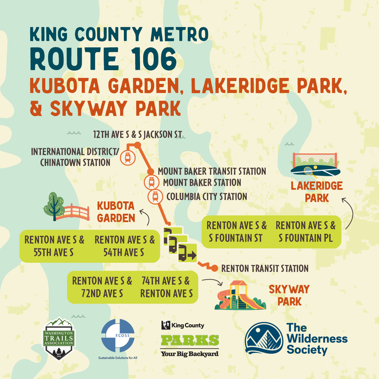
ride King County Metro 106 to GET TO Kubota Garden, Lakeridge Park, and Skyway Park
Kubota Gardens is a Japanese garden in the Rainier Beach neighborhood of Seattle. It is free to explore the 20 acres of garden, including 11 ponds, over 100 varieties of maple trees and plentiful hydrangeas. The park features bridges, forests, creeks and more. The Kubota Gardens also connects to the Chief Sealth Trail, which is a paved 4.3-mile one-way trail connecting the gardens to Jefferson Park.
The bus for route 106 drops you off at the entrance of the Kubota Gardens. Route 106 starts at the International District / Chinatown station in Seattle and ends in Renton. It only operates on weekdays. You can also use the Link Light Rail to cover a portion of your journey to Kubota Gardens by getting off at the Rainier Beach station and taking either the 106 bus or using the rideshare app VIA Transit Shuttle.
If you continue South on route 106, you can also find Lakeridge Park and Skyway Park. Lakeridge Park offers a mile-long trail through a recovering forest. Skyway Park is undergoing a number of revitalization efforts that will bring new amenities — like ADA accessible paths and playgrounds — to it in coming years.

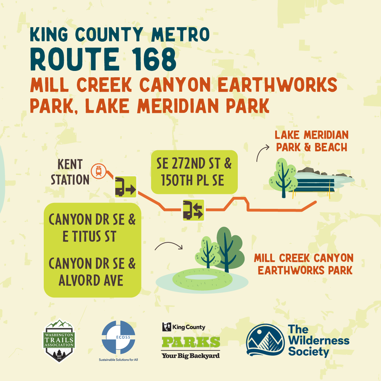
Ride King County Metro 168 to Mill Creek Canyon Earthworks Park, Lake Meridian Park
King County Metro bus 168 can take you to Mill Creek Canyon Earthworks Park and Lake Meridian Park. Earthwork Park is a one-of-its-kind greenspace and environmental art site with a paved walking trail. Lake Meridian Park is at the end of Lake Meridian in Kent. You can find lots of opportunities to swim, fish or enjoy the beach. It’s a great place to play and includes a large playground and plenty of options to recreate on the water.
You can reach Eathwork Park by getting off at the E Smith St & Jason Ave N stop of the 168 bus and walking 0.2 miles to the park. To reach Lake Meridian Park using bus 168, travel 0.3 miles after getting dropped off at the SE Kent-Kangley Road and 132nd Avenue SE stop. The 168 bus route serves Maple Valley, Timberlane and the Kent Station and it runs all week.
FINDING A WAY TO GET OUTSIDE
Owning a car doesn’t need to be the only way to access the outdoors. This list is just the beginning of options to get to green spaces without a car. To find more options, use King County Metro’s trip planner or Sound Transit’s trip planner to plan your own journey to parks. WTA’s Hiking Guide also offers useful location information on many trails in King County, some of which include information on public transportation. Even with a car, opting to use public transportation is a more sustainable way to travel and frees up space at the trailhead.
We hope you’ll try out a new way to get to a park — and if you’d do, we’d love to hear about it in a trip report.


Comments