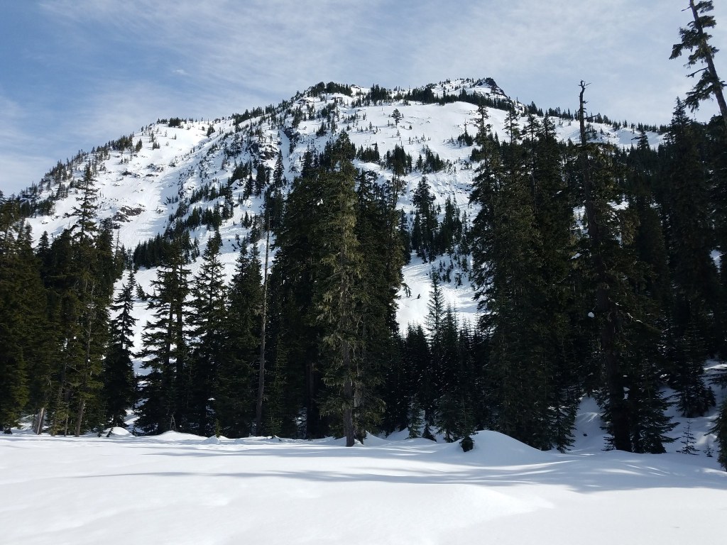
You are here: Home Find a Hike Hiking Guide Commonwealth Basin Snowshoe

Commonwealth Basin Snowshoe

» REI » Amazon

A portion of all book sales from the links above benefits WTA and helps protect and maintain our trails.

The section of the Pacific Crest Trail (PCT) north of Snoqualmie Pass is overrun with hikers every summer weekend, but put a few feet of snow on the trail, and the crowds ignore it. That's great news for snowshoers because the trail is easy to get to and enjoyable for snowshoeing. The route to Commonwealth Basin follows the PCT for more than 2 miles through shadowy old-growth forest--with an occasional break in the trees for views of the surrounding peaks--before setting off on a smaller path into the wide, rocky basin at the base of Red Mountain.

Commonwealth Basin affords excellent views of the iron-rich flanks of Red Mountain, although snowshoers will be at a loss to explore the source for the mountain's name since it is covered in a deep quilt of white snow all winter. There are also excellent views up to Kendall Peak and Snoqualmie Mountain from the basin.

Just north of the freeway underpass, a small snow-covered road climbs off to the right. Snowshoe up this road into a wide summer parking area at the PCT trailhead. The trail leads off from the east end of the parking lot, rolling up through thick forest on a long traverse to the east before looping through a switchback corner near 0.7 mile and climbing northwest. After looping through a couple more short switchbacks, the trail rolls north to a junction at 2.5 miles (4000 feet).

An alternate route, when snow is very deep, is to snowshoe up the narrow valley directly above the PCT parking area. Stay left and climb through the trees, keeping the small creek basin on your left until reaching the broad mouth of Commonwealth Basin.

The route to this point is easy to follow because the trail corridor is wide and obvious in the heavy forest. The trail stays under the forest canopy nearly all of the first 2.5 miles, although it does cross the base of a large avalanche slope and then recross the slope higher up after climbing through a switchback. Cross this slope with care, and if the avalanche danger is higher than moderate, avoid the area. The point where the trail crosses the slope is on the run-out section of the chute rather than the trigger area, so it is unlikely that you will trigger a slide here, but caution is still required.

At the trail junction, stay left--the PCT climbs steadily to the right--and follow the Commonwealth Creek valley up into the basin. The trail is a long, straight ascent up the valley, climbing gradually as it enters the basin. The forest thins, and finally falls away at 4 miles, leaving you on open slopes at the base of Red Mountain. Potential for avalanches exists here beyond timber line, so care and common sense must be used in heavy doses. If the snow is stable and safe, it's possible to scramble up to the 5300-foot level (about 5 miles from the trailhead) at a low saddle on the ridge between Red Mountain and Lundin Peak. The last 0.5 mile of climbing is steep and should be attempted only by those with experience in snowshoe mountaineering.

Author’s Rating: Backcountry
These routes follow topography rather than trails or roads. Skill with a map and compass is essential. A variety of conditions may be encountered along backcountry routes, including steep elevation gains and losses. These routes require complete competence in winter survival skills, avalanche and snow condition evaluation and some basic mountaineering skills.
Driving Directions:

To get there, from Seattle drive east on Interstate 90 to exit 52 (Snoqualmie Pass, West Summit). Stay on right and park in the open ski area lots closest to the freeway. Carefully -- paying attention to traffic -- walk through the underpass to reach the trailhead on the north side of I-90.

Improve or add to this guidebook entry

Note: the description and driving directions for this Mountaineers Books entry are copyrighted and can't be changed.

Recent Trip Reports

Hiked here recently? Submit a trip report!
There are 46 trip reports for this hike. See all trip reports for this hike.
Commonwealth Basin Snowshoe — Apr 13, 2012 — raBBit
Snowshoe/XC Ski
Expand report text Hide report text
Conditions are what are expected for early spring. There is still a good snow base. Snow in the sunn...
Conditions are what are expected for early spring. There is still a good snow base. Snow in the sunny patches is soft on top. Creek is running. Snow bridges are getting fewer and narrower - you have to go along the creek a little ways to reach it. If you are looking for a workout, skiing would be better - trail is fairly smooth. If you are looking for less and more quietitude - snowhoe to the other side of the creek and meander around the trees off the cut trail. Friday was balmy so light layers were best but it did feel drafty sitting by the creek.
Read full report with photos
Commonwealth Basin Snowshoe — Mar 24, 2012 — Olga
Snowshoe/XC Ski
Expand report text Hide report text
We got to the trailhead around 10am. The directions say to park on the north side of the highway in ...
We got to the trailhead around 10am. The directions say to park on the north side of the highway in a plowed out area - we looked for that and only found private parking. We parked instead at Summit West and walked over.

The trailhead was extremely easy to find as somebody carved steps coming from the main road up.

The trail is well visited. It breaks off into different branches many times but always seems to meet back up together. So take the trail you feel like taking. It is packed well, so you can make it for the first half a mile or so without snowshoes - after that it was less packed and I wouldn't risk falling through all the time. Especially since there are several pieces of the trail right next to the creek.

It was a beautiful day - loads of beautiful snow formations and sunlight. We stopped hiking 2.5 miles in at the meadow clearing. There was maybe one or two sets of tracks going forward, but we turned around since we didn't have a good map. We saw about 5 groups on the way there mainly toward the end of the trail which all turned around at the same place. There were quite a few more people hiking out around noon.

Overall - a great easy snowshoe.
Read full report
Commonwealth Basin Snowshoe, Cave Ridge — Jan 16, 2012 — Cruiznbye
Day hike
Issues: Snow on trail
Expand report text Hide report text
Following a few days of new snow in the Snoqualmie pass area, we decided to explore the Commonwealth...
Following a few days of new snow in the Snoqualmie pass area, we decided to explore the Commonwealth basin and attempt to attain the saddle between Guye Peak and Cave Ridge. It was holiday (MLK) so the ski areas were open and there were lots of people skiing and also snowshoeing in the Basis.

Parked at the W. Summit Ski lot and walked across to the Pacific Crest Trailhead. We took the first left off the main trail to follow the Old Pacific Crest trail down to the Commonwealth creek. Log crossing was fine and then the fun begins. Before the creek crossing the trail was well-packed and back-country skiers had made a nice trail as they headed to Red Mountain slopes. After crossing the creek and heading toward Guye and the saddle, the new snow had piled in about 14 inches deep with no established trail. Stream crossing were a bit of a challenge as snow bridges were very small and narrow.

The farther we went toward the saddle the deeper the snow became. At about 4000 feet we were into about 3’ of fresh, granular powder. There was a slight crust at about 14” deep, but not enough to hold and weight and another 20” of powder below the buried crust. Small sloughs on the steeper slopes were evident and making progress in the deep powder was excruciatingly slow. There was no way of kicking in steps because of the powder and sideways traversing was the only way to gain elevation. A slow process indeed.

After another hour of pushing forward, we called it a day at 4350’ elevation, still 350’ short of the saddle. The snow was heavy most of the day and by the time we got back to the car it was falling so fast and furious that we needed to chain up to get home.

In the Commonwealth basin, great snowshoe conditions, though on the trail in you would only need traction (spikes or yak tracks). Off trail there was plenty of soft powder for snowshoes.

With the storms forecast to this week, the upper areas will be 6-7 feet deep with unconsolidated powder and very avalanche prone. Snowshoeing in and around the Commonwealth basin should be excellent as temps remain below freezing and so much fresh powdery snow piling up.

Pictures from the ridge attempt:

http://www.flickr.com/[…]/

Read full report with photos
Commonwealth Basin Snowshoe — Jan 13, 2012 — raBBit
Snowshoe/XC Ski
Expand report text Hide report text
Spent a few hours snowshoeing starting on the PCT and out through Commonwealth Basin following a har...
Spent a few hours snowshoeing starting on the PCT and out through Commonwealth Basin following a hard packed trail which was easy to follow. The snow had a crusty top layer. There were a few creeks that were running which were not difficult to cross but the banks were icy. The day was partly overcast with sunbreaks allowing clear sighting of the surrounding peaks and a beautiful icicle waterfall along the PCT.

There were not a lot of cars parked at the Snoqualmie Summit parking lot and only ran into a few people along the trail. Temperature in the 30's but sure this and trail conditions will change when the forecasted snow and arctic air arrives.
Read full report with photos
Commonwealth Basin Snowshoe — Dec 20, 2011 — john deer
Snowshoe/XC Ski
Expand report text Hide report text
The conditions in Commonwealth Basin are pretty good for an easy, introductory snowshoe trip. Eithe...
The conditions in Commonwealth Basin are pretty good for an easy, introductory snowshoe trip. Either the FS is running their "pony ride" trips or a lot of people have been into the area recently. The tromped in path up the old PCT is easy to navigate to the creek crossing. A short ways before the creek crossing, there are 2 very short detours to the creek for very nice snow and waterfall views. Crossing the creek on the narrow bridge is OK but narrow. Once across the creek, tracks go in multiple directions. We headed northward towards Red Mountain but stopped at a creek/waterfall overlook after about 900 feet of total elevation gain. Apparently, this is also the stopping point for the FS pony rides.

On the return trip, we tried to do some exploring to the east but had some unpleasant adventures trying to cross the creek. I could elaborate but it would be embarassing. Let's just say that it is good to carry extra clothes; we disproved the theory of the conservation of mass; and we got lucky. How it that for a cryptic description?

We did not check out the new PCT but that track was really punched in also, at least near the junction with the old and new trails.
Read full report
CommonwealthBasinSnowshoerSchiefelbein.jpg
Photo by Dave Schiefelbein.
Location
Commonwealth Basin (#1033)
Snoqualmie Pass -- Snoqualmie Pass
Mt. Baker - Snoqualmie National Forest - North Bend District
Statistics
Roundtrip 10.0 miles
Elevation Gain 2300 ft
Highest Point 5300 ft
Features
Mountain views
Guidebooks & Maps
Green Trails: Snoqualmie Pass No. 207

Improve or add to this guidebook entry

Note: the description and driving directions for this Mountaineers Books entry are copyrighted and can't be changed.

Map it
Red MarkerCommonwealth Basin Snowshoe
47.4282289 -121.412428
(47.4282, -121.4124) Open in new window
Document Actions
  • Email this page
  • Print this
  • Share

Mountaineers three booksSelect content from The Mountaineers Books' guidebooks is featured in this Hiking Guide. Sales of the books from this website help protect and maintain trails.

> Shop Now

More hikes » Hike of the Week
Ingalls Creek

Ingalls Creek

Central Cascades

This trail is a true springtime gem for hikers and backpackers. Walk beside a raging whitewater creek swollen with snowmelt, enjoy the blooms of wildflowers and gaze up at the Stuart range.

Get Trail News

Subscribe to our free email newsletter for hiking news, events, gear reviews and more.

What's Happening
Hike the State Jun 06, 2012 It's like speed dating, for trails. 7 Regions, 7 Experts, 7 Minutes....Go!
More »