
The Upper Dungeness Trail is a gateway trail. It is not only a great hike all by itself --on the way to its end at Marmot Pass it links to other high reward hikes in the northeast Olympics – Royal Basin, Goat Lake, Heather Creek, and Home Lake. From Marmot Pass one can continue to either the Upper Big Quilcene or Tubal Cain Trail.
The hike starts out easy and stays easy for the 3.4 miles to Camp Handy. About a mile up the trail you’ll enter the Buckhorn Wilderness when you step off the footlog bridge over Royal Creek. Here, the river often runs close to the trail. You’ll spy a milky grey tint to its waters in still pools. This color comes from suspended glacial flour contributed by the meltwater sources of the Upper Dungeness tributaries. At about 2.6 miles you’ll cross the Dungeness on a stout bridge.
Camp Handy comes into sight along the rivers edge at 3.4 miles. Its expansive riverfront meadow and cedar shingle shelter make it a popular campsite for people, which in turn has made it a popular cafeteria for gray jays and chipmunks. Take the side trip down to the meadow and enjoy the views up the valley toward Constance Pass and Inner Constance. This is where some people may elect to turn around, which gives you a 6.4 mile roundtrip hike with 600 feet of gain. But there are more views to be had further on.
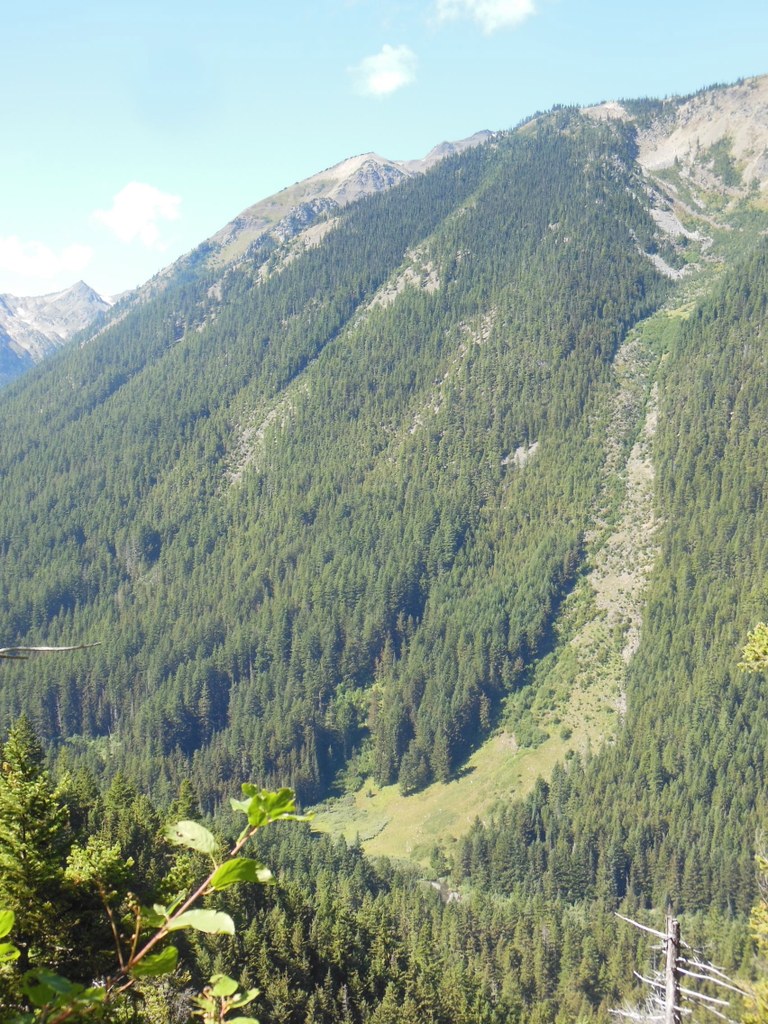
From Camp Handy, the trail climbs without switchbacking in the three miles to Boulder Shelter. The trail crosses two good water sources along the way. At several points, the westward vistas offer clear views into the Milk Creek and Heather Creek drainages and at numerous avalanche paths on the opposite side of the valley.
You’ll arrive at Boulder Shelter at about 6.4 miles. The shelter was standing as of this writing in 2014, but much of the nearby area is strewn with avalanche snapped trees--harsh winters can take their toll on the area and the shelter may not be standing when you visit. The creek at Boulder Shelter offers the most reliable water on the trail.
Next stop is the end of the trail--Marmot Pass, 8.1 miles from the trailhead. But you’ll probably be stopping along the switchbacks above Boulder Shelter either for a rest or to take in the broad views. As the trees peter out, take a look around and enjoy the clumps of contorted white bark pine. As the trail makes its final northward ascending traverse to Marmot Pass you might encounter some steep and somewhat exposed snowfields as late as early July. Be prepared and check recent trip reports.
Marmot Pass via Upper Dungeness River Trail

-
 Length
- 16.2 miles, roundtrip
-
 Elevation Gain
- 3,500 feet
-
 Highest Point
- 6,000 feet
12.29.25: FR 2880 has a rockslide 0.5 mile past Dungeness Forks Campground (before the junction with FR 2870) on the road. Trails are still accessible via FR 2870.
The Upper Dungeness Trail is a gateway trail. It is not only a great hike all by itself --on the way to its end at Marmot Pass it links to other high reward hikes in the northeast Olympics – Royal Basin, Goat Lake, Heather Creek, and Home Lake. From Marmot Pass one can continue to either the Upper Big Quilcene or Tubal Cain Trail.
Continue reading
Parking Pass/Entry Fee
Northwest Forest PassHiking Marmot Pass via Upper Dungeness River Trail

WTA worked here in 2020, 2019, 2018, 2015 and 2014!
Map & Directions
 Trailhead
Before You Go
12.29.25: FR 2880 has a rockslide 0.5 mile past Dungeness Forks Campground (before the junction with FR 2870) on the road. Trails are still accessible via FR 2870.
Parking Pass/Entry Fee
Northwest Forest PassWTA Pro Tip: Save a copy of our directions before you leave! App-based driving directions aren't always accurate and data connections may be unreliable as you drive to the trailhead.
Getting There
From beautiful Blyn on US 101, check your odometer at the intersection of 101 and Sophus Road on the west side of the Longhouse Deli and gas station, and head towards Sequim on 101. In 1.7 miles take a left onto Louella Road. Take Louella 0.9 miles to its end at the intersection with Palo Alto Road, and turn left on Palo Alto. Follow Palo Alto for 5.8 miles and turn right onto Forest Road 2880. This gravel road winds steeply down for 0.9 miles until you cross the bridge over the Dungeness River and drive past the Dungeness Forks Campground. In another 0.9 miles, you arrive at an intersection. Go straight (not right) on what is now Forest Road 2870. In another 2.5 miles bear right at an intersection to stay on 2870. In another 4.9 miles, take the left fork to stay on 2870. In 1.6 miles, you will again cross the Dungeness River and be at the sizable trailhead parking lot. Trailhead amenities include picnic table and vault toilet.


