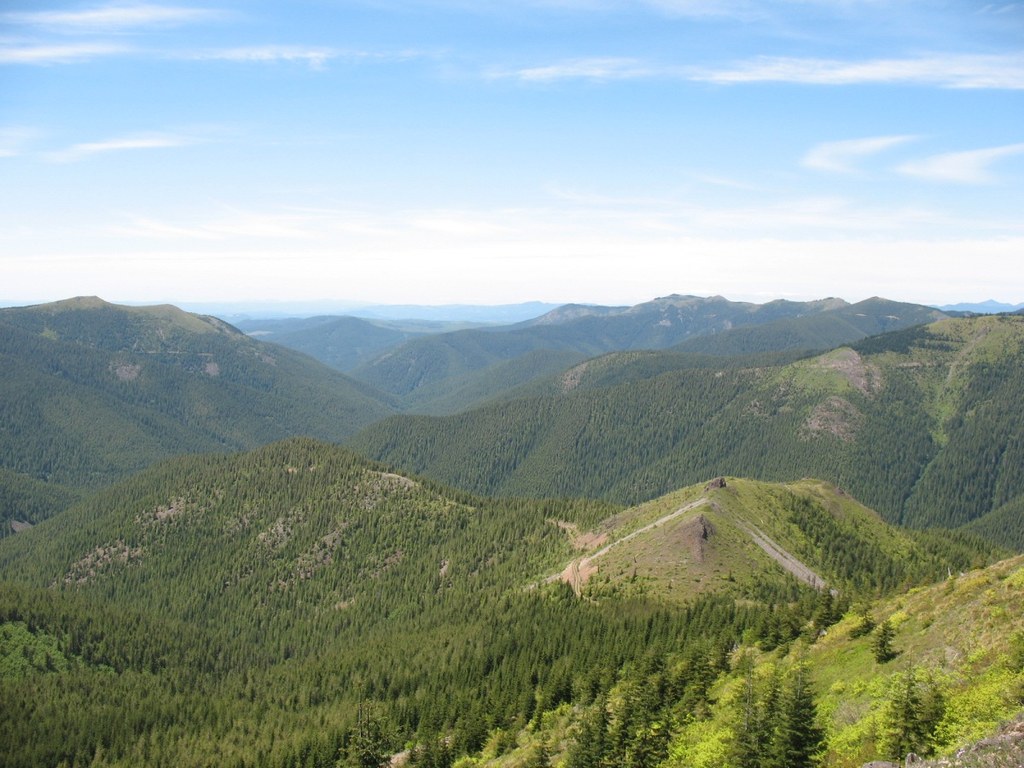
East Fork Lewis River
The East Fork of the Lewis River Trail (#139) is a little bit off the beaten path so it doesn't get much maintenance, but it doesn't get crowded either. Maybe another reason it isn't visited often is the road to get there is full of pot holes.
The trail starts out crossing the river on an abandoned car bridge. The first miles is actually an old road bed grown over with Alder, so its not that exciting or scenic. But then the route goes across the river, but this time - no bridge. Instead you need to get your feet wet or crawl across one of the many trees fallen across the river. On the other side the trail continues on an abandoned road, but the alders are taller and lush sword ferns abound. About 2 miles in you pass some flat areas that might do for small campsite right along the trail. Then you cross the river again but by now the river has diminished in volume and the crossing is less scary. Beyond this crossing evidence of the old road disappears altogether and the forest thickens. Every so often there is a huge fire scarred old growth trunk; like tombstones commemorating the 1903 Yacolt Burn that swept through the area. The last couple miles climb steadily upwards and the trail starts to disappear, covered over by ferns and other vegetation. As you ascend the south facing slope, it gets drier and the trees smaller and more dispersed allowing glimpses of Lookout Mountain above. Finally the trail ends at spur road 599. From there you can follow 599 to the saddle between Little Lookout Mt. and Lookout Mt. at about where 599 intersects road 4220. There is a great view of Mt. Hood. To get a little higher up scramble up another 1/8 mile to the rocky summit of Little Lookout Mountain (4,000).
Driving Directions:
Go North on I-5 from Vancouver, take exit 9, and take highway 502 east for 7.7 miles to Battle Ground. Or from I-205 from Vancouver, take highway 500 East (exit #30) which turns into 503 North to Battle Ground. 502 (Main St.) and 503 (Lewisville Hwy) intersect in Battle Ground near a mini-mall with a Safeway. Go north on 503 for about 6 miles. Turn right on Rock Creek Road and go about 8 miles continuing past Lucia Falls and Moulton Falls. Turn right on Sunset Falls Road just past Moulton Falls. Continue east for about 7 miles. Continue past Sunset Campground. The road now becomes FS Road 42 as you enter the Gifford Pinchot National Forest. Follow 42 for about 5 miles (there are lots of pot holes). Look for a wide spot on the left side of the road. Where there was once a road crossing the river is overgrown and blocked with large boulders. (I did not see a trail head sign there). Recent Trip Reports
Hiked here recently?
Submit a trip report!
There are
5
trip reports for this hike.
East Fork Lewis River
— May 31, 2013
— fionduir
Day hike
Expand report text
Hide report text
Read full report
This trail is an awesome one. I first hiked it back in the mid 80's. Back then the road continued be...
This trail is an awesome one. I first hiked it back in the mid 80's. Back then the road continued beyond the washed out bridge and came to an end at the river. It is amazing how quickly the road is going back to nature. In some places you can't even tell it was a road. This time of year there is a lot of muddy areas and small run off streams but nothing deeper than your ankles.
About a mile in you have to cross the river and after a week of rain it was a bit deeper than I figured it would be. There used to be a set of cables you could use to cross but those are long gone. There are logs that span the river but they were not very accessable, so I had to just wade across. I'm 5'10" and the water was up to my crotch and pretty swift. Getting across with my pack was a bit of fun. The next mile or so used to be a road also but how long ago im not sure. It was overgrown with alders in the 80's. My step father told me people used to live up there and my first trip through there as a kid I had found spots with old floor boards and even an old wood stove that was full of bullet holes. Over all it is a pretty easy trail to follow. At this point you have to cross the river again and it is much easier to cross. On this side the trail gets a bit harder to see but you can still clearly see it for quit a ways. Again the first time through here as a kid there used to be a cabin about 40 yards up the trail from the river. It said Pine Flats Mining on it and there was a claim post outside. Inside we found pieces of newspaper from world war 2. Some time in the late 80's it was tore down. Past this point it gets harder to see the trail in a lot of places and starts climbing. I didn't go much further than this my last trip so I can't say how the trail is further up since I haven't travelled it in 8 years or better. The wild flowers were just starting to bloom but in the summer they are everywhere. In the summer months you will also find all sorts of berries. In the fall there are lots of hazel nuts. Wild life is very plentiful. As far as bigger animals go there are lots of deer, some elk and I've seen sign of bear but have never actually seen one. Luckily just tracks, mauled berry bushes and droppings. It's a very secluded trail and if you like the sound of the river and not much else I highly recomend it.
East Fork Lewis River
— Nov 04, 2012
— Weluv2hike.
Day hike
Features:
Fall foliage
Issues:
Mudholes
Expand report text
Hide report text
Read full report
Trail in good cond. Very beautiful, the Lewis River with the color turning of the trees. We went to ...
Trail in good cond. Very beautiful, the Lewis River with the color turning of the trees. We went to La Center bottoms and followed the river 2.2 mile rt.
Day hike
Expand report text
Hide report text
Read full report
with photos
As the other trip reports indicate, the East Fork Lewis Trail (#139) is a tricky one to find. The b...
As the other trip reports indicate, the East Fork Lewis Trail (#139) is a tricky one to find. The bumpy drive along Forest Service Road 42 is likely impossible if you don't have a high clearance vehicle and even if you do, you're forced to go pretty slowly. In the directions listed above, it should be noted that if you are coming from Sunset Campground, the parking area for the trail will be 5 miles down Forest Service road 42 on your right, not your left.
Due to time constraints on my end I wasn't able to hike the whole trail, but got far enough in to experience the two river crossings. There are some big trees along the first one that make for easy crossing, and the second one has a piece of parachute chord that was strung along above a log that can be used as a good means to steady yourself for the second crossing. However, if you're feeling nervous about crossing on a log, the water is calm enough and shallow enough to walk across, as long as you don't mind getting a little wet. I went another two miles towards the summit and the trail in there could use some widening and bench cutting in some sections. The trail is a nice peaceful hike with some great views. It's too bad that its a challenging one to get to, but if you've got the car I would definitely recommend checking it out!
East Fork Lewis River
— Aug 29, 2011
— rfschreiner
Day hike
Features:
Ripe berries
Issues:
Overgrown
Expand report text
Hide report text
Read full report
The East Fork trail (#139) isn't easy to find by any means. If you are not paying attention you may ...
The East Fork trail (#139) isn't easy to find by any means. If you are not paying attention you may miss it. However, I suspect you will be paying attention as the road conditions prevent anyone from going very fast. The trail head is practically unmarked. A short brown post is all that remains of the trail head sign. The post is next to the gate for the 559 Rd, which is also unmarked. If you have a map it isn't too difficult to figure out.
The trail itself is in rough shape. It needs work. Even so, it is easy to follow and may offer some beautiful views. I was there in cloud cover so it was difficult to tell. Though, I believe the cloud cover offers a distinctive beauty that cannot be found any other way. Right now this whole area is flushed with Huckleberries as well as pickers. While on this trail I heard some loud crashing noises very close and getting closer so at a certain point I felt uncomfortable and turned back. I noticed some claw marks on a few trees. Berries=Bears? I came in from Vancouver and went through sunset falls campground up the 41 Rd. This road is pretty bad. It took about 45 minutes to do 13 miles. I went out toward Carson down the 43 Rd. The way out was much better. It may be the better way to go. All in all, I really did enjoy this trail. There is camping near by and it would be a great overnight destination. Day hike
Issues:
Bridge out | Overgrown
Expand report text
Hide report text
Read full report
with photos
I hadn't seen any info on this hike or met anyone who had done it, so I went. Its a rough trail in p...
I hadn't seen any info on this hike or met anyone who had done it, so I went. Its a rough trail in places with a dicey river crossing, but I love the remote feel of it and knowing that you probably won't see another soul on the trail.
It was tiring and hot climbing up the south face of the ridge, but the views were worth it and there were quite a few wildflowers making their appearance. I also really liked hiking through different environments from the logging road reverting to forest, witnessing the charred remains of old-growth from the Yacolt Burn returning to a Doug-fir forest, and seeing the transition from lush valley bottom to dry rocky, bear grass slopes. |
![]() Looking back from the end of the trail down into the East Fork Lewis River drainage. R.Ojerio
2011
Map it
|
Document Actions
- Email this page
- Print this
- Share


