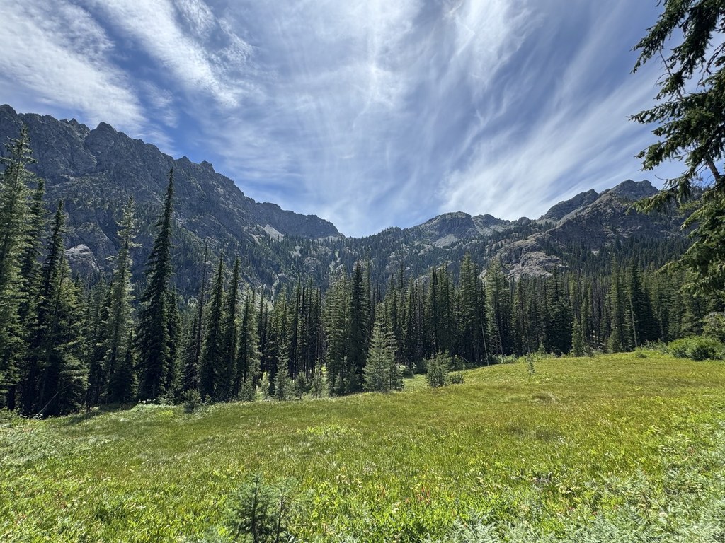
Esmeralda Basin
Last modified
Oct 30, 2009 04:07 PM
Contributors:
Dahlia
A wonderland of wildflowers (and one of the most diverse selections you'll find on any one hike) will greet you, especially June through August.
The Esmeralda Basin and the adjoining segment of the County Line trail lie in an unprotected area of the Cle Elum Ranger District, Wenatchee National Forest, just south of the Alpine Lakes Wilderness. The trailhead features two rustic picnic tables beneath a small but dramatic waterfall. The first 1/4 mile of the trail is a bit rough and moderately steep, following along a raging creek. The slope soon becomes much gentler, suitable for children, and the trail gradually follows an abandoned mining road up the Esmeralda Basin between Esmeralda Peaks and Ingalls Peak. Enter a lush meadow at .4 mile, where the Ingalls Lake trail #1390 heads off to the right(note: no dogs are allowed on the Ingalls Lake trail). The Esmeralda Basin trail #1394 leads gradually up through a beautiful series of wildflower meadows and woods. Enjoy glacier lillies and spring beauty early; shooting star, phlox, wild strawberries, paintbrush, columbine, and desert parsley in July. Good campsites may be found along the trail. At 2 miles the mining road heads off to the right and the trail switchbacks up the south slope of Ingalls Peak through more meadows toward Fortune Creek Pass. The next trail junction is just beyond a small stream crossing at 5900', 3.1 miles from the trailhead. Trail #1394 turns west, leading over Fortune Creek Pass and down to Fortune Creek 4X4 trail #4W301. The County Line trail #1226.2 climbs north to another lovely meadow, and then follows an old watercourse to an unnamed pass above tiny Lake Ann. It is more like a route than a trail in places. The views from the pass are grand. To the north a broad vista looks out over numerous peaks in the Alpine Lakes Wilderness, and to the south rise Esmeralda Peaks and Hawkins Mountain. Pine and Engelmann spruce grow at the pass (6400'), and a great campsite on the ridgeline is sheltered by spruce and a wall built up of rocks. The trail continues north from here, dropping down to Lake Ann about 250' below and then on to Van Epps Pass and 4X4 country. Round trip hiking time to the nameless pass is about 5-6 hours. Watch out for road apples--equestrians use this trail. Recent Trip Reports
Hiked here recently?
Submit a trip report!
There are
110
trip reports for this hike.
See all trip reports for this hike.
Multi-night backpack
Features:
Ripe berries
Expand report text
Hide report text
Read full report
with photos
We (including kids ages 7-11) just returned from a wonderful 3-day midweek hike counterclockwise around Esmeralda Peaks, with one night...
We (including kids ages 7-11) just returned from a wonderful 3-day midweek hike counterclockwise around Esmeralda Peaks, with one night each at Esmeralda Basin (note: wta.org misspells this "Esmerelda", so try searching for that) and Gallagher Head Lake. We encountered several hikers at the Esmeralda trailhead destined for Lake Ingalls but no hikers on our trail. We did encounter one car north of the lake and one group of motorbikers while we were camped at the lake, but the bikers left quickly and none of these vehicles marred our trip.
There are several good campsites at Esmeralda Basin. They're all at the turnoff 2 miles into the hike where there's a sign on a tree for the Esmeralda Basin trail. There's a small stream near near the campsites although it's almost dry; I'm not sure how much longer it will be usable. The toilet in this site is essentially full. An old mine, including some equipment, is located just above the campsites. The vistas as you cross Fortune Creek Pass are starkly beautiful. It was a little breezy up there but we enjoyed stopping for a while and taking the 2-minute walk up a small hill. Shortly after you get down to the 4x4 road and then start ascending again, the road splits, but don't worry; both roads rejoin each other a few minutes later. When you read that Gallagher Head Lake is shallow, believe it; right now it's less than a foot deep (everywhere, as far as we could tell) and very muddy. But it's still a decent water source, it's filled with frogs that kids love to play with, and it's possible to get wet (I found a nice log to sit on) if you want. There's a nice campsite on the south end of the lake with a toilet marked by red tape. The road access is probably to blame for the few cans, bottles, and pieces of broken glass that we found in and around the firepit, but none of those are a huge problem. The lake is to easy to find and leave, but to clarify, it's to the east of the road (the Falcon guidebook shows it to the west). Also, from the campsite there is a trail that leads directly to the DeRoux Creek trail #1392 without requiring you to return to the road. There are wildflowers along all the route although they are past their prime. We found some huckleberries around both campsites and some incredibly sweet thimbleberries (see photo) about two-thirds of the way down from the lake to the DeRoux campground. Bugs were not a big problem -- just a few mosquitoes and flies. We chose to do this trip counterclockwise because it made for a shorter first day and it saved the better campsite for last. However, either direction would work well; probably the most important consideration is to avoid being at the lake on a weekend if possible due to the motorized access. Day hike
Features:
Wildflowers blooming | Ripe berries
Expand report text
Hide report text
Read full report
with photos
Last week my parents came and my son came to visit us here in Ellensburg. The intent was to...
Last week my parents came and my son came to visit us here in Ellensburg. The intent was to get everyone outside and up as much as possible over the course of the week. I had planned many day trips and overnighters, but the common denominator of our collective experience limited us to one of each. Still everyone had a great time and while my distances were down last week, the time I spent outside getting what I got was way up.
On Monday of last week I took everyone up to Esmerelda Basin (#1394) which is an old favorite for Tess and me. The parking lot was incredibly full for a Monday. Dad and I had to jokey two trucks into the little left over space remaining. There was another group of kids getting ready for what looked like an overnighter into the backcountry. Big frame packs and ice axes, no ropes or helmets. I tried to keep my chuckles to myself. Considering the traffic in the parking lot the trail was undeniably untrammeled. The kids must have turned off to Ingalls Lake because we didn’t see anyone all the way up. There has been quite a bit of drying out in this valley this summer. You can still find water and there are places with blossoms showing, but where the trail is exposed to sunshine it has been ground to a fine, dusty powder and it gets pretty toasty from time to time. Soon the whole family was stopping to dip bandanas into cold mountain water. Tie one of these around your neck and the world suddenly cools a few degrees. The summit took a while to get to, but everyone trucked along chatting and enjoying one another’s company. I tried to stay behind with the dogs and was impressed that Justin was doing so well with the addition of trekking poles. We ate lunch at the pass and soaked it all in for a bit then on the return trip we started to run into more people. A camp gaggle from down the way of horse riders, several groups of young people returning from parts unknown, and some interspersed couples on their way back. This was a predictably good way to start off the week. Everyone had a good time. Day hike
Features:
Wildflowers blooming
Expand report text
Hide report text
Read full report
with photos
The 10 mile dirt road to the trailhead is in very good condition, as is the trail itself. Though a...
The 10 mile dirt road to the trailhead is in very good condition, as is the trail itself. Though a little past the peak, the wildflower show is still spectacular, but many plants have flowered and gone to seed. The trail is bone-dry and dusty, yet there are still many plants in bloom. The mixed geology here allows for many diverse species to live along different parts of the trail, and it's interesting to see the variations due to different mineral content of the soil, which makes for a unique ecology in the basin.
Surprisingly there is a lot of running water along the trail, with several small creeks feeding into the North Fork Teanaway River that parallels the trail for the first quarter mile or so. In spite of all the water there are no mosquitoes at all; I didn't see a single one. There are the usual biting flies, but these are so stupid that they sit there as you slap them into oblivion. At the end of the hike, at Fortune Creek Pass, the landscape is suddenly rather barren and forbidding - I've never seen anything quite like it (see picture). Esmeralda Basin is a great day hike and I highly recommend it.
Esmerelda Basin
— Jul 07, 2009
— jjdebord
Day hike
Features:
Wildflowers blooming
Expand report text
Hide report text
Read full report
My parents,wife and myself decided to hike Esmerelda basin and were not disappointed. There are still plenty of wildflowers and...
My parents,wife and myself decided to hike Esmerelda basin and were not disappointed. There are still plenty of wildflowers and very few bugs. I would recommend hiking this area soon for the flowers won't be as abundant much longer. My only word of caution is be careful on the road it has a substantial number of ruts and potholes on it.
Esmerelda Basin
— Jul 01, 2009
— Navigator
Day hike
Expand report text
Hide report text
Read full report
Sorry for the double post. I'm having problems uploading images....
Sorry for the double post. I'm having problems uploading images.
|
Driving Directions
Exit I-90 east of Cle Elum. Take SR 970 north to the Teanaway Road. Follow the North Fork Teanaway Road to the 29 Pines Campground where the pavement ends at a fork in the road. Take the right fork, FR 9737, 10 miles to its end at trailhead #1394, Esmeralda Basin.
|
Document Actions
- Email this page
- Print this
- Share


