Green Mountain
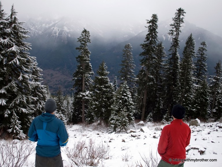
This hike is sometimes called Last Promontory; Absolute Last Promontory and starts out as a road walk on the CCC road; then climbs another road to a viewpoint east of the Green Mt summit. From here the route is a very rough trail or scramble route directly up the ridge line to the summit.
Driving Directions:
I-90 to exit 32; left across freeway to stop sign; left on "old highway"; right on Mt Si Rd; follow to pavement end; continue for about 1 mile to blue DNR gate. Recent Trip Reports
Hiked here recently?
Submit a trip report!
There are
13
trip reports for this hike.
See all trip reports for this hike.
Green Mountain, CCC Road: Lower Trailhead
— Apr 24, 2013
— Marblemaria
Day hike
Features:
Wildflowers blooming
Issues:
Blowdowns | Mudholes | Water on trail | Snow on trail
Expand report text
Hide report text
Read full report
I began at the west end of the ccc road, DNR gate 902. I would not recommend this start anymore as I...
I began at the west end of the ccc road, DNR gate 902. I would not recommend this start anymore as I noticed the discover pass signs have been removed and have been told the neighbors are none too friendly to hikers. Start instead by driving up The Middle Fork and following the ccc road back to the SW
The CCC road was dry and free of blow downs. Once off the road and on to the trail it was mostly free of snow all the way to the promontory, but there was some water and a lot of blow downs. All of the stream crossings are easily crossable. just make sure you brought gaiters for later. The promontory had a little snow but there were many spots to sit and eat. The memorial for the recent hiker that died is still there. Right before the promontory the trail continues unmarked to the left, currently marked with red tape, thanks to the green mountain trail angel. I'll get to him later. The snow becomes pretty slushy and tiring to navigate. I continued up to about 3200 ft where I lost the red tape and the snow became to deep to be enjoyable. On the way back down I ran into Paul, the Green Mtn trail angel. He's been cleaning up the trail with his trusty hoe and corona saw, that he highly recommended I get. Day hike
Features:
Wildflowers blooming | Ripe berries
Issues:
Blowdowns | Clogged drainage | Overgrown | Mudholes | Washouts | Water on trail | Snow on trail | Bugs | Avalanche danger
Expand report text
Hide report text
Read full report
with photos
It should be noted that parts of Green Mt Trail are steeper than the worst parts of Mt Teneriffe or ...
It should be noted that parts of Green Mt Trail are steeper than the worst parts of Mt Teneriffe or Mailbox Peak. I would not attempt this hike without a pair of sturdy trekking poles, and if there is any chance of snow traction devices are a necessity.
One way to get there is to start down the CCC Trail from Mt Si Road, but I prefer to park at the first bridge down the Middlefork Snoqualmie Road about five miles in. There is an unofficial trail heading downstream on the north side of the bridge that will take you through a dense temperate rainforest, past massive old growth douglas firs and over 3 log crossings before dunping you out onto the CCC Trail. Turn right, moving NW for a few feet to find where the trail continues on the left, quickly coming to a T. Turn right again and begin the ascent. This road turned trail crosses Brawling Creek(be sure to look down to admire the natural waterslide below you) and hits 3 sets of switchbacks, pass by the junction on the left and you will arrive shortly at Last Chance Promontory and the turnoff to Green Mountain Summit. Take in the views of the Middlefork Valley, if you're lucky enough to have clear skies youe can see Mailbox Peak to Dirty Harry, Mount Washington, Thompson Mtn, Revolution Peak, Russion Butte, and Preacher Mtn, amongst others nearby peaks. From here the climb really begins so get ready to gain over 2000' of elevation in less than a mile. The bootpath starts up a rocky stretch right at the viewpoint and is easy to miss if you don't look closely, but you wil know you are on the right path when you quickly come to a talus field that spans the crest of the ridge. Keep an eye out for cairns that mark the path in a few tricky spots but from here the path will closely ride the ridge to the summit. orange tape adorns trees on the way up, but there was more of it on fallen branches than up in the trees. I wish I would have brought some so I could refresh the route markings. I encountered patches of snow above 3500' and it was up to 4' deep everywhere after 4000' or so. Some fairly fresh powder to bite into but where there was solid canopy above, which was most of the ridge,is was compacted and iced over. Microspikes and poles were barely cutting it, crampons and an ice axe would be much more useful. Upon reaching the summit, it was still blanketed by thick clouds, obscuring any views as was the case yesterday on Mt persis. At least today there was no rain, although I'm glad I decided to put on my raingear as soo as I did to avoid dew from overgrown vegetaion. I did this with a dog but I would not recommend doing so unless you and the pup have a decent amount of backcountry experience, particularly before the snow is gone. Day hike
Issues:
Blowdowns | Clogged drainage | Overgrown | Washouts | Water on trail | Snow on trail | Bugs | Avalanche danger
Expand report text
Hide report text
Read full report
with photos
A lot of care has gone to the construction of the unofficial trail from the first middle fork bridge...
A lot of care has gone to the construction of the unofficial trail from the first middle fork bridge to the CCC road/trail. I recommend parking on the south side of the bridge as there's more room on the shoulder trail start on north side heading down stream. After two small creek crossings, one with a nice log bridge with a railing, the climb begins through a dense forest sprouted from the remains of old logging complete with massive stumps of ancient Doug firs.
The trail crosses two abandoned and overgrown logging roads, joining one of them shortly. The only short muddy section of this otherwise well maintained trail is just before the well traveled CCC Trail. Turn right and look for the trail to continue in just a few feet on the left, or turn left (sw on the CCC) and then take the first fork and stay to the right on the last chance promontory road/trail. In just over a tenth of a mile you will pass the trail from the CCC on the right and a utility marker on the left before the road begins its steep climb. This long abandoned road takes you through switchbacks and over many creek crossings, and in wet conditions or when snow is melting above, there are a few sections where the aged drainage these installments have failed leaving the gravel road to act as a large gutter. About 2 miles from the CCC fork, take a left and westbound to green mountain, or continue east to the viewpoints. The Green mountain trail is from the remnants of yet another abandoned logging road. After crossing the brawling Creek yet again the you will curve around a southeastern ridge as the road fades into a slight bootpath to the northwest. This is where the red and orange flags become essential. at the last intersection with brawling creek I lost the flags for good and switched back westbound following the faint melted out tracks of a solo hiker across a huge, steep snowfield, undoubtedly blanketing access of talus.on the other side of the snowfield I reached the saddle between green mountain and Mt Teneriffe, which I followed the remaining 200' to the southernmost, and first of 2 false summits.the rock atop this small peak is currently free of snow, but there are fairly big cornices covering the boot path to the north making this the stopping point for me and my dog. We enjoyed some glissading on the way down. It won't be more than a few Weeks before it will be to far melted to do that here.the snow line started around 3500', and was up to 5 feet deep up to 4500'. There is still potential avalanche danger in a few places, be careful out there! Day hike
Issues:
Blowdowns | Water on trail | Snow on trail
Expand report text
Hide report text
Read full report
with photos
Flickr: http://bit.ly/green-mountain
Still bummed about the weather on Park Butte, I decided to g...
Flickr: http://bit.ly/green-mountain
Still bummed about the weather on Park Butte, I decided to get out again today to catch some nice weather. Since I have been wanting to hike Green Mountain and the North Bend area was going to be mostly sunny, this was a perfect choice. The dogs got their weekly hike on Park Butte yesterday, so it would just be me on this hike—a little “me” time. This time I had no problem locating the Sitka Spruce trail this time. It’s just past Granite Creek on the other side of the concrete bridge. Not too eventful between here and the old CCC road. Once the road started to ascend after passing the CCC road, I was surround by lots of trees and a few long switchbacks without much view. The valley finally came into view once I reached Promontory vistas. Snapped a few photos there and off to the promontory trail I go. The trail was quite steep and it reminded me of Red Mountain (Painted Mountain) quite a bit. Snow showed up at 3,000’ and continued all the way to the top. The trail followed the ridge line to the summit with pink tape throughout, pretty self-explanatory. What do you know? It was mostly sunny until just before I got to the summit. Somehow the clouds all decided to roll in at the same time. My view to the west was nonexistent, but I managed to get some decent photos of some of the east peaks. Mailbox Peak was a hit-or-miss, no views on Mount Teneriffe or Mount Si either. Not sure if the latter two would be visible even under a clear sky? On the way down I ran into a few guys just before reaching Promontory Vistas. They turned out to be part of The Seattle Gay Hiking Group and had questions about the trail condition to the summit. I probably would have stayed and visited with them a while longer if I wasn’t trying to make it back to Seattle on time to see a SIFF film. Day hike
Issues:
Mudholes | Water on trail | Snow on trail
Expand report text
Hide report text
Read full report
with photos
I joined the Mounties for a rainy hike & scramble of Green Mt in the Middle Fork Snoqualmie River wa...
I joined the Mounties for a rainy hike & scramble of Green Mt in the Middle Fork Snoqualmie River watershed. We followed a well maintained trail that starts at the Middle Fork Rd (#59) just north of the major bridge crossing, goes through a patch of old growth spruce & hemlock up to the CCC Rd, then follows an old logging road up to the beginning of the east ridge of Green Mt, just above 3000'. We then followed a steep, flagged route through talus, woods & finally snow to the summit. Views were non-existent, the rain constant & the only reward was in the effort & the fellowship.
This could be a good trip under better conditions, with great views of Russian Butte, Mt Garfield & the Middle Fork Valley. There is little or no avalanche danger on this route despite the exposure. There might be some problems with brush in a few spots on the ridge later in the year. You could hike up to the start of the ridge & still have a very rewarding day. Walk south (left) on the CCC Rd a few hundred yards after leaving the initial approach trail to find the logging road which bears right. Go right at the first major fork after that & the way should be clear from there. |
![]() On the talus field below the summit of Green Mountain. Photo by hikingwithmybrother.
|
Document Actions
- Email this page
- Print this
- Share


