
There's no question why Ingalls Lake is one of the most popular destinations in the Alpine Lakes Wilderness. It is a stunning blue lake, set high in a basin beneath rocky peaks, showcasing striking Mount Stuart as its backdrop. The trail to this treasure is filled with delights, both for the summer adventurer as well as for those hikers who appreciate fall colors. Views of the craggy Esmeralda Peaks, a walk through beautiful Headlight Basin plus a pretty picture of the imposing Stuart Range are just a few of the wonders along the way.

The hike travels through a number of ecosystems which make this a unique traipse through the Teanaway Valley and into the Alpine Lakes Wilderness. Beginning in a forested valley decorated with a host of wildflowers and underbrush, the trail meets a junction in about 0.4 of mile, marked Ingalls Way. Turn right here; traveling straight will take you into Esmeralda Basin.
The path immediately makes its way up the hillside, soon exiting the pine trees and entering open country. At approximately 1.4 miles, another trail junction begs you to venture right and up to Longs Pass, a side trip that adds 1.4 miles round-trip to your adventure. Continue straight on the trail, gently weaving in and out of contours in the dramatic landscape on your continual climb to Ingalls Pass.
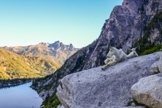
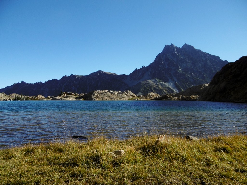
Constant views of the Esmeralda Peaks and Fortune Pass keep hikers enticed for more. As the trail nears the pass, it takes long switchbacks that flirt with rocky meadows and even better views on its way into the alpine. At about three miles, reach Ingalls Pass, where the views become vast, with Mount Stuart and the Ingalls Peaks in close proximity. The basin below to the north is filled with green, grassy meadows strewn with streams, abundant flowers, and popular alpine larches before it becomes a rocky walk and scramble to the hidden lake on the far side of the basin. It is here that one might begin counting mountain goats and other high-country wildlife.
At the pass, the trail forks. The left fork is the more distinct trail, providing a meandering route around and down the pass towards the lake. The right fork offers a more direct, but more rough and rugged route to Lake Ingalls. Route-finding via cairn may be required at times, before it rounds a bend and heads up a draw into a unique and special lake basin.
Camping is prohibited at the lake. If you plan to camp, take the right branch of the trail, which drops into Headlight Basin and numerous camps, some with views across the Ingalls Creek valley to Mount Stuart. This lower route continues across Headlight Creek, then climbs to meet the other trail at a signed junction less than a quarter-mile from the lake.
The lake is a spectacular sky-blue and surrounded by rocks that fall in giant slabs into the water’s sandy floor. Ingalls Peaks reach high above the lake on the one side, while Mount Stuart stands majestically to its northeast. There are few places as lovely as this. Follow a boot path around the far side of the lake for a different, beautiful perspective.
WTA Pro Tip: Be prepared on summer weekends to share this wilderness wonder with other outdoor enthusiasts. It’s a destination that cannot be denied. In the fall, the larch trees turn an electric orange which will surely draw the eye.
** Note: Dogs are not allowed at Lake Ingalls. Canine friends are allowed on the trail to Esmeralda Basin, which shares the first 0.4 miles with the trail to Lake Ingalls. However, from the junction of the Esmeralda Basin trail and the Ingalls Way trail, dogs are no longer allowed. This includes Ingalls Pass and the Longs Pass.
 Trailhead