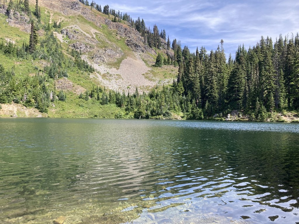
You are here: Home Find a Hike Hiking Guide Margaret Lake

Margaret Lake

» REI » Amazon

A portion of all book sales from the links above benefits WTA and helps protect and maintain our trails.

Who wants to hike in old clear-cuts? When they're packed with huckleberries, I do! If the huckleberries aren't ripe yet, you'll find paintbrush, lupine, columbine, and other wildflowers coloring the trail. Besides, the old clear-cuts found on the lower portion of this route peter out quickly as you climb the ridge before dropping into the picturesque lake basin.

Head up the gravel road leading past the parking lot and in 0.25 mile veer left onto a small dirt road. Hike around an old cable gate and climb the dirt road as it slants steeply upward into an old clear-cut. Don't let the ugly connotations of that label fool you, however. This field of stumps has been reclaimed by native flora--acres of huckleberries punctuated by an array of wildflowers. Beargrass, lupine, paintbrush, tiger lilies, fireweed, and more grace these slopes.

The road peters out in 0.5 mile and the narrow trail weaves upward, providing great views south over Keechelus Lake and back up toward Snoqualmie Pass. As you near the ridge Mount Rainier comes into view far to the south, too.

About 1.5 miles from the trailhead, the trail enters forest and, at 2 miles, reaches a junction near the ridgeline. To the left is Lake Lillian. Turn right instead to cross the ridge and descend a steep mile to Margaret Lake. The lake is a wonderful place to relax and enjoy a refreshing dip after lunch before heading back up and over the ridge.
Driving Directions:

From Seattle drive east on I-90 to exit 54 (signed "Hyak"). Turn left (north) under the freeway and right on the frontage road marked "Gold Creek." After about 0.5 mile turn left (north) on Gold Creek Road (Forest Road 4832) and drive east, parallel to the interstate briefly before the road angles upward. At 3.9 miles from the freeway turn left onto FR 4934, and in 0.25 mile look for the parking lot on the left.

Improve or add to this guidebook entry

Note: the description and driving directions for this Mountaineers Books entry are copyrighted and can't be changed.

Recent Trip Reports

Hiked here recently? Submit a trip report!
There are 54 trip reports for this hike. See all trip reports for this hike.
Margaret Lake — Sep 23, 2012 — Coach
Day hike
Features: Fall foliage | Ripe berries
Issues: No water source
Expand report text Hide report text
This hike started with a somewhat requisite search for the parking area & trail head. It's not obvi...
This hike started with a somewhat requisite search for the parking area & trail head. It's not obvious. I believe the succession of roads leading to the parking area may have changed given construction on I-90.

Re Directions: The forest service roads are not well marked so you have to feel your way, but the map does show the roads correctly for the most part. Take the rt as described on Gold Creek Road, BUT ignore the .5 mile left. The map takes you further east until the road turns uphill & switchbacks a bit (+/- 4 mi.) you come to a 'Y' where you bear right, then shortly thereafter you hit a 2nd "Y" ...stay left (Uphill). This will switchback and take you to the parking area on the left.

Parking: This area requires the forest service pass.

Trail head: Back out the entrance and up the road (not thru the back of the parking area). Its actually about 250 yds up, then bear left & up another road grade marked by rusting yellow gate posts(no gate). Eventually you hit the actual trail & marker. This beginning trail crosses back over another road a little further ahead before it leaves the road system altogether.

Hike: The logged area is as described, but the new growth is establishing itself & w/ trees, berries and color. A little dusty on a hot day. It climbs steadily. The forested area is very nice & soon you'll reach the ridge where you drop to Margaret Lk or continue left towards Lilian. It's quite a drop into the lake. You end up climbing quite a bit before dropping in. It's still a nice day trip, but it's a little more work than the usual 3 miles 1800 might imply. Worth it though. It's a nice quiet little lake. I think a lot of folks bail at the top and settle for the view.

A few bugs (no-see-ums) but manageable. No water on the trail unless you reach the Lake. Weather permitting, this will be beautiful in the coming weeks.
Read full report
Margaret Lake — Sep 23, 2012 — Mountain hiker
Day hike
Features: Fall foliage
Expand report text Hide report text
This was a surprisingly beautiful trip. The area in the hike description that is described as a clea...
This was a surprisingly beautiful trip. The area in the hike description that is described as a clear cut is actually now about 10 years old, and lovely new trees are growing as well as colorful fall foliage. When you first approach the lake don't be misled by a small pond that you see. It is a pretty pond, but the beautiful lake lies just a few 100 feet away and its the real beauty. As you see in the pictures the fall foliage is definitely out, probably not even at its prime though. the views looking towards Lake Kachees were a bit foggy looking, I think probably due to forest fires in eastern Washington. As others have reported be sure that you don't follow the trail at the far end of the parking lot, but go back towards theentrance to the parking lot and follow a bit further up the road. There is a good sign to indicate that, but I might not have taken the time to read it if I hadn't seen the post by another hiker on this trail. We were actually alone at the lake by the time we arrived this afternoon. Amazing for an 1-90 corridor hike on a beautiful day.
Read full report with photos
Margaret Lake — Sep 04, 2012 — BigButtDon
Day hike
Features: Wildflowers blooming | Ripe berries
Issues: No water source
Expand report text Hide report text
What started out as a hike to Lake Lillian got truncated due to a bofus move in the parking lot. Fa...
What started out as a hike to Lake Lillian got truncated due to a bofus move in the parking lot. Failed to read the sign at the parking lot and took off on the trail at the end of the lot. This took us on a 3 mile, 2 hour diversion on an unmarked trail that immediately screamed "wrong". Regaining our composure and reading the parking lot sign in full, we were off again on the right path - if you can call it that. The hike to the ridge kinda stinks - maybe I was just crabby. The steep, rocky, dusty road followed by steep, rocky, dusty path grinding up to the ridge offered nothing other than a few views and some posies to admire. The "clearcut" is now has tree growth about ten years old (?). At about 1.5 miles and 1200' elevation gain, you finally enter the forest. The trail gets nice with gradual switchbacks in a pretty, older growth environment. 200 more feet elevation and you encounter the junction to the lake and path to Lake Lillian. Drop 350 feet on a steep path to Lake Yvonne and then over to Margaret. Outstanding lunch spot on a rock outcropping on the SE side of the lake. Didn't go for a swim but it was enticing. All in all, I won't do this hike again - that trashed "clearcut" did me in. Gotta love our toilet paper! Might try Lake Lillian thru the Lake Laura Backdoor instead.
Read full report with photos
Margaret Lake — Aug 27, 2012 — gracefulc
Day hike
Features: Wildflowers blooming | Ripe berries
Issues: Bugs
Expand report text Hide report text
Lost trekking pole at parking lot for trailhead. Offering reward! Lost 8/27 between 7:30pm and 10:30...
Lost trekking pole at parking lot for trailhead. Offering reward! Lost 8/27 between 7:30pm and 10:30pm (I went back for it but it was already gone). Please email me: hankinsc@gmail.com if found!
Read full report
Margaret Lake — Aug 25, 2012 — Francesca_TX
Day hike
Features: Ripe berries
Expand report text Hide report text
My husband and I had a little difficulty finding the trail head - but luckily our trail map had the ...
My husband and I had a little difficulty finding the trail head - but luckily our trail map had the forest service roads clearly marked and we were able to find our way!

Lots of huckleberries in the exposed old clear cut portion of the trail.

Lake was beautiful and I definitely regretted not bringing a bathing suit as it was a hot day and there were many swimming. Next time!

Read full report with photos
lake margaret roobug.jpg
Lake Margaret. Photo by Roobug.
Location
Margaret Lake (#1332.1)
Snoqualmie Pass -- Snoqualmie Pass
Okanogan-Wenatchee National Forest, Cle Elum Ranger District
Statistics
Roundtrip 6.0 miles
Elevation Gain 1800 ft
Highest Point 5100 ft
Features
Lakes
Mountain views
Ridges/passes
User info
Dogs allowed on leash
Northwest Forest Pass required
Guidebooks & Maps
Day Hiking: Snoqualmie Pass (Nelson & Bauer - Mountaineers Books)
Green Trails Snoqualmie Pass No. 207

Improve or add to this guidebook entry

Note: the description and driving directions for this Mountaineers Books entry are copyrighted and can't be changed.

Map it
Red MarkerMargaret Lake
47.3641833333 -121.358166667
(47.3642, -121.3582) Open in new window
Document Actions
  • Email this page
  • Print this
  • Share
Get the Guidebooks

Mountaineers three booksSelect content from The Mountaineers Books' guidebooks is featured in this Hiking Guide. Sales of the books from this website help protect and maintain trails.

> Shop Now

More hikes » Hike of the Week
Steamboat Rock (May 16)

Steamboat Rock

Eastern Washington

Looking for warm, dry hiking with stunning views and a post-hike swim? Climb to the top of Steamboat Rock and ramble the butte top for dramatic views of Banks Lake and coulee country. Desert wildflowers and camping options sweeten the deal.

Get Trail News

Subscribe to our free email newsletter for hiking news, events, gear reviews and more.