
The way to Melakwa Lake is like two different trails: first a wide gentle trail through old growth forest beneath an elevated and noisy Interstate freeway. And second, a rocky steep trail that follows a waterfall and a precipitous gorge upstream to get to a pair of clear alpine lakes flanked by rocky peaks. Is it about the journey or the destination? You decide.
Start out from the trailhead on a wide trail that meanders through forest, with trees young and old. Due to its popularity, this part of the trail has been the focus of numerous trail maintenance outings, yet there are still rocks and roots to contend with; that’s just the nature of the terrain.
At a half mile, freeway noise peaks as you pass under the elevated span of eastbound Interstate 90. Then at just over 1 mile is a popular natural feature known by various names: the Denny Creek Water Slide, Slide Rock, the Slippery Slab. This is the destination for many families, for frolicking and/or picnicking on a hot summer day. If this is your destination, see our hiking guide entry for Denny Creek.
At the water slide, Denny Creek is posted as “Impassible During High Water”. In normal flows however, strategically placed rocks offer a dry crossing. The trail re-enters pleasant forest on the opposite side, marked by a sign on a large tree that reads “Main Trail”. A quarter mile from the water slide, the trail passes through an area of lush vegetation then breaks out into the open, revealing two tiers of Keekwulee Falls, the main drop falling 90 feet into a steep ravine. In the morning, the falls can be seen glinting in the sunlight.
Climb more earnestly after this point, alternating between open talus and forested shade. At 1.9 miles, hear Denny Creek echoing off the walls of its narrow gorge above Keekwulee Falls, finally drowning out freeway noise. At a couple of switchbacks, the trail offers views almost straight down for those who may want to peer down the steep walls.
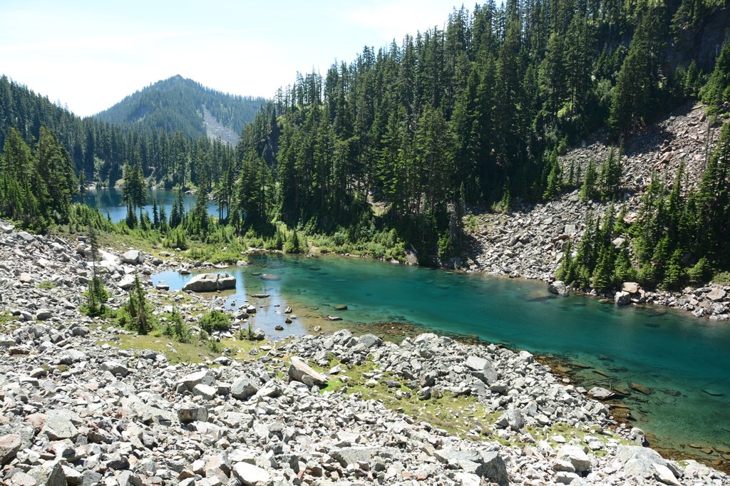
At 2.25 miles, the trail levels off for 0.2 mile until it crosses gently gurgling Denny Creek on a footlog beside a huge cedar snag. The rest of the way to Hemlock Pass is steep as you alternate between talus and forest. In season, there may be few wildflowers blooming in this section. At 3.8 miles, top out at Hemlock Pass, 4600 feet. Continue the final 0.4 mile, losing 150 feet of elevation to arrive at the outlet of Melakwa Lake. A massive logjam offers one way to cross the outlet stream. Just on the other side is a popular gathering place for hikers and a signed trail to a privy. Enjoy the lake and wonder at the meaning of its name. Hint: “Melakwa” is Chinook for “mosquito”.
To get to the smaller Upper Melakwa Lake, continue 0.2 mile along the left side of the lake. Cross the stream connecting the two lakes to get to campsites on either lake, or to continue wandering, e.g. to Melakwa Pass.
On the return, remember to take the upper trail at the junction 100 feet past the logjam, to climb back up to Hemlock Pass.
Melakwa Lake

-
 Length
- 8.5 miles, roundtrip
-
 Elevation Gain
- 2,700 feet
-
 Highest Point
- 4,600 feet
Parking Pass/Entry Fee
Northwest Forest Pass, Sno-Parks Permit
The way to Melakwa Lake is like two different trails: first a wide gentle trail through old growth forest beneath an elevated and noisy Interstate freeway. And second, a rocky steep trail that follows a waterfall and a precipitous gorge upstream to get to a pair of clear alpine lakes flanked by rocky peaks. Is it about the journey or the destination? You decide.
Continue reading
Hiking Melakwa Lake

Map & Directions
 Trailhead
Before You Go
Parking Pass/Entry Fee
Northwest Forest Pass, Sno-Parks PermitWTA Pro Tip: Save a copy of our directions before you leave! App-based driving directions aren't always accurate and data connections may be unreliable as you drive to the trailhead.
Getting There
From Seattle, head east on I-90 to exit 47 Denny Creek/Tinkham Road. At the top of the exit ramp, turn left and cross over the freeway. Go 0.2 miles and turn right at the stop sign onto Forest Road 58. The road crosses under the freeway, after driving 0.2 miles, turn left.
Continue straight on for 2.9 miles and about a half mile past the Denny Creek Campground there are three large parking lots on the right that can accommodate about 170 cars.
There is an electronic payment station at the first parking lot for those who do not have a valid pass. Road side parking is not permitted in this area so make sure you have an alternate location to hike if the parking areas are full.
Various connector trails lead from the parking lots to the Denny Creek and Franklin Falls trails. There is ADA parking available nearer the Franklin Falls trailhead. Be sure to have a placard; parking patrols are on and will ticket violaters.


