
The “old” trail that ascends Mount Si’s western flank offers a shorter, steeper, slightly more scenic, and if one dare say it — less crowded — route to the summit, where you can rejoin the rest of the people who flock to one of Snoqualmie Pass’s most popular hiking destinations.
This route to reach Mount Si’s haystack shares a trailhead with the Little Si route and passes through a boulder-strewn saddle between Si and its much shorter subsidiary peak. Be aware that weekend parking could pose a challenge at the Little Si trailhead, but there will be nothing little about your hiking experience.
Start your ascent on the Little Si trail. After 0.3 miles you will come to a junction with the Boulder Garden Loop. If you prefer a counterclockwise loop, make a right turn and briefly descend, then ascend a moderately steep grade past building-sized, moss-adorned rock behemoths and reach the junction with the Old Mount Si trail 1.2 miles later. If you are eager to summit sooner, continue 0.2 miles from the first junction to the second junction with the Boulder Garden Loop and make a right turn, reaching the Old Mount Si junction at in 0.6 more miles. Either way, as you hike, enjoy the recovering Douglas fir and western hemlock forest that dominates in the loop area and at lower elevations on Si.
The Old Mount Si trail takes off up and to the right at a signpost that does not indicate the destination of the ascending trail; it's signed for the directions of the Boulder Garden Loop trail. However, as you leave the loop, the elevation gain leaves no uncertainty that you are headed in the correct direction — up.
Hike carefully in snow, because the trail is steep and tends to be icy. Traction devices like crampons are highly recommended. Ascend 2.4 steep miles at a grade of 1000 feet per mile, switchbacking up the mountain through mountain hemlock and ultimately fir forest. You will come close to the new trail on a hairpin near the end of this segment, but keep left to avoid the crowds.
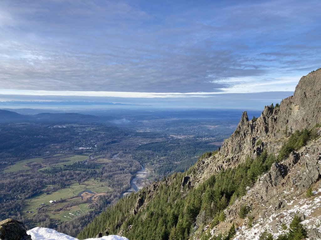
You will reach the junction with the new trail along a turnpike segment. Take careful note of this unmarked junction — it's important for your return trip. If you miss it, you'll to return to the wrong parking lot! Join the new trail here, and head up some more. Soon the haystack will hove into view. The basin and the haystack at the top of Si, along with panoramic views of West Defiance Ridge, the Snoqualmie Valley, and Puget Sound are only 0.2 miles away.
On your descent consider taking the segment of the Boulder Garden Loop that you missed on your ascent to complete a round trip of 7.4 miles.
WTA Pro Tip: Hike this trail during the winter or on weekdays to experience more solitude.
Mount Si - Old Trail

-
 Length
- 7.4 miles, roundtrip
-
 Elevation Gain
- 3,420 feet
-
 Highest Point
- 3,980 feet
Parking Pass/Entry Fee
Discover Pass
The “old” trail that ascends Mount Si’s western flank offers a shorter, steeper, slightly more scenic, and if one dare say it — less crowded — route to the summit, where you can rejoin the rest of the people who flock to one of Snoqualmie Pass’s most popular hiking destinations.
Continue reading
Hiking Mount Si - Old Trail
Map & Directions
 Trailhead
Before You Go
Parking Pass/Entry Fee
Discover PassWTA Pro Tip: Save a copy of our directions before you leave! App-based driving directions aren't always accurate and data connections may be unreliable as you drive to the trailhead.
Getting There
Take exit 32 on I-90 East for 436th Ave SE. Turn left onto 436th Ave SE, drive 0.6 miles. Turn left onto SE North Bend Way, drive 0.3 miles. Take the 1st right onto SE Mount Si Rd, drive 0.4 miles. Look for overflow parking lot on your left and main parking lot nearby with a sign marked "Little Si".


