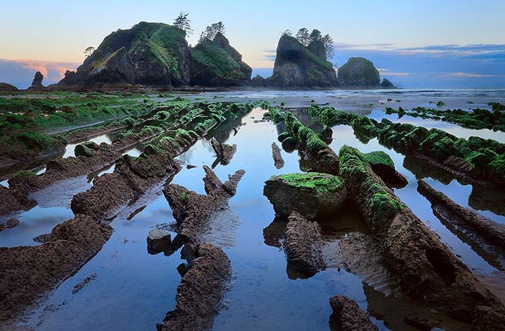
You are here: Home » Find a Hike » Hiking Guide » North Shi Shi Beach Access - Point of Arches

North Shi Shi Beach Access - Point of Arches

Last modified May 24, 2009 01:29 PM
Contributors: Susan Elderkin
Inge Johnnson's photo of Point of Arches took 2nd prize in WTA's Northwest Expsoure Photo Contest in 2008.
Shi Shi Beach is a wonderful destination in any season - there is no better place to experience the power of the ocean, the majesty of sea stacks, the wide expanse of beach, and small creatures in tidepools.

Summertime brings crowds and sunny weather, but the other three seasons each have their own advantages. Most noticeably is the absence of people, leaving you to roam this special place alone (or with the coyotes). Tides and storms are more extreme in the winter, adding a sense of adventure but also requiring more caution.

The toughest part of trail is at about 1.5 miles. The Makahs have developed a new beautiful trail, but it doesn't quite cover all of the muddy sections just before your descent to the beach. Be prepared for muddy boots, especially during the rainy months.

At two miles, the trail descends to the beach. It's a steep - but mercifully short - drop to the glorious sandy beach. Ahead you'll be drawn to the majestic presence of Point of Arches. It's a bit over two miles of beach and driftwood walking to get there - but well worth it.

Petroleum Creek drains to the sea about halfway down the beach. There are some well-established campsites near nearby. Do stay overnight if you can. Sunsets are ,and it will increase your chances of visiting Point of Arches during low tide - lots of sea creatures to peer at, and you won't want to turn back quickly.

Do note if you're staying the night to camp well back from the beach itself; the tides often come all the way up to the bluff! All hikers and campers should carry tide tables to avoid untimely scrambles up the bluff and into the brush.
Improve or add to this guidebook entry

Recent Trip Reports

Hiked here recently? Submit a trip report!
There are 21 trip reports for this hike. See all trip reports for this hike.
North Shi Shi Beach Access - Point of Arches, Cape Flattery — May 22, 2009 — Cheetarzan
Day hike
Issues: Mudholes
Expand Hide report text
Memorial day weekend can be iffy weather-wise. And Friday morning in Forks didn't look very promising. Heavy clouds showed little promise of...
Memorial day weekend can be iffy weather-wise.
And Friday morning in Forks didn't look very promising.
Heavy clouds showed little promise of dispersing during the morning hours.
We escaped the clouds by moving north.
Sunny and clear by the time we stopped in Neah Bay to get our Makah Permit.
(Get it at the mini-mart, don't wait for the tribal center)
The Flattery trail was in good shape and a crew was making it even better.
("Maybe we'll get to the Shi Shi trail next year")
A few clouds at the cape but gorgeous.

The second half of the Shi Shi trail has many mudholes and the trail is getting wider as hikers attempt to keep their footwear dry. The hike down the bluff to the beach is steep and dicey. It can hardly be called a trail.
(I wonder how the guy with the full pack, surfboard and half-rack got down.)
Once we safely got to the beach it was wonderful.
But where were all those backpackers we passed on the way out going to camp?
Read full report
North Shi Shi Beach Access - Point of Arches — Apr 25, 2009 — Eric Jain
Overnight
Issues: Mudholes
Expand Hide report text
Headed to Shi Shi Beach this weekend expecting not so great weather, and was surprised by almost perfect weather. Stopped...
Headed to Shi Shi Beach this weekend expecting not so great weather, and was surprised by almost perfect weather. Stopped at the visitor center in Port Angeles on the way to get a camping permit ($9) and a bear cannister ($3 donation). Stopped in Neah Bay at the museum to get a "recreation pass" ($10, good for one year) that appears to be required as well.

The parking lot at the trailhead is for day use only. Ended up leaving the car about a mile away at "Donna's" parking lot ($10). The owners of nearer parking lots were nowhere to be found, and some of the places looked a bit dubious. Fortunately the guy at that parking lot offered to drop us off at the trailhead.

The first half of the trail is immaculate and consists of lots of boardwalk. Then things get a bit muddy. Fortunately most of the mud was either dried out or bypassable. After rain or heavy use things might look different... In any case the trail is well marked.

Down at the beach there were three other parties camping, well spaced out. Didn't have trouble finding a good spot, but was glad to have a tide table handy and to be able to compare the evidence of the last high tide with the next expected high tide. There was plenty of firewood lying around, and no garbage (perhaps thanks to the recent coast clean-up day?). Should have brought binoculars to watch the sea otters, and to look out for whales...

The next morning we walked along the beach to Point of Arches and back. The tide was low at -1 so there were plenty of tide pools to peek into, and walking was easy. The only obstacle was a small stream, which could be crossed without getting wet feet on the lower part of the beach.

Read full report with photos
North Shi Shi Beach Access - Point of Arches — Apr 11, 2009 — Raghu
Day hike
Issues: Mudholes | Water on trail
Expand Hide report text
Seeing the Sea stacks was something we wanted to do on a hike for a long time. We decided that...
Seeing the Sea stacks was something we wanted to do on a hike for a long time. We decided that whatever be the weather, we would go to the Shi-Shi beach in the Makah nation.

The drive from Seattle is around 4.5 hrs, and with breaks for rest, it can be around 5.5 hrs. We reached the trailhead around 1:30 PM. The drive on SR 112 west is full of curves, but beautiful when you have the ocean around.

We went on a rainy day. It rains most of the days near the Shi-Shi beach, and the day we went was no different. The views of the ocean are filled with mist when it rains. It must be really good when sunny or even cloudy.

The trail head is easy to find from the town of Neah Bay. The trail consists of 2 distinct stretches, one from trail head to beach, and the other along the beach. Both are almost 2 miles each, so the total one way distance is around 4 miles. The first stretch from trailhead to beach was full of mudholes.It was extremely muddy, soggy, wet, some pits had lots of water, and most of our shoes got easily wet. In fact, its a very difficult hike for the first 2 miles just because of the extent of mud. Lot of perseverence is a must to cross the first 2 miles. In extremely bad portions of the trail, look out for some side trails [near the side of the main trail] and try to use that whenever you can. The trail is very very slippery and lot of caution is needed.

The hike is fairly flat but its strenuous only because of the muddy trails. Once down to the beach, its beautiful. The beach was beautiful even in the rain, and so it must be awesome on a sunny day. We could see the sea stacks and point of arches at some distance from the first entry point on the beach. The sea stacks were not clearly visible because of the mist formed by the rain. Still it looked good.

We had to hike for some 2 more miles to reach the Point of Arches where the view of the sea stack is great because you are very close to it. Hiking on the beach is a little bit tricky, because the beach is not a flat surface and it is some amount of strain on the ankles and legs to hike on such a soft surface. There are no trail markers once in the beach, and we just kept going left to a place full of sea stacks which we assumed would be the Point of Arches based on some of the pictures we had seen before.

We did not check the tide maps and stuff, but we were lucky enough to be able to reach Point of Arches easily. The view of the sea stacks was majestic, and we were left wondering how the view could have if there were no rain. On a sunny day, the sunset should be really awesome and even the views of the sea stack simply majestic. The ocean water wave crashing sound was simply great to hear and reminded us the power of nature and water. It was cold with the breeze and we were feeling colder because we had been wet, water entering our shoes, and continuing showers. But with so less people around, it was a nice place to enjoy solitude at this time of the year.

After spending some time at Point of Arches, we headed back. All the struggle against muddy trails continued, and we are quite happy to reach the parking lot by 6 PM. A drive of another 5 hours and we reached Seattle.

For those looking to visit this hike, my suggestions would be to check the forecast and go only if its sunny. The mud would probably be gone, and the sea stacks would be terrific. And if possible, make it a backpack. There are some nice places to camp in the beach away from the tides.

Bottomline: Its a must go hike just for the sea stacks but plan well for the forecast and go on a sunny day.
Read full report with photos
North Shi Shi Beach Access - Point of Arches — Apr 07, 2009 — Hekele
Day hike
Issues: Mudholes
Expand Hide report text
The recent beautiful weather has helped to dry out the trail a bit. Mud was still prevalent, but the worst...
The recent beautiful weather has helped to dry out the trail a bit. Mud was still prevalent, but the worst sections could all be bypassed on the sides, or over wood placed across them. Be careful on the side trails - one or two of them lead to bigger mudholes than they bypass. I was told that the trail was 'pretty muddy' by several people, but it all seemed manageable with even slightly-waterproof shoes. I wouldn't hike it in running shoes, but any hiking boots would be fine. At least, until it rains again!
Read full report
Shi-shi beach,Point of Arches — Dec 11, 2007 — GaliWalker
Day hike
Issues: Blowdowns | Mudholes | Water on trail | Overgrown
Expand Hide report text
Dec 11, 2007: Shi-Shi Beach to Point of the Arches Additional Photos: http://www.flickr.com/photos/shahiddurrani/sets/72157603434722184 Dramatic sea stacks, a pristine beach, crashing waves, foaming...

Dec 11, 2007: Shi-Shi Beach to Point of the Arches

Additional Photos: http://www.flickr.com/photos/shahiddurrani/sets/72157603434722184

Dramatic sea stacks, a pristine beach, crashing waves, foaming seas, and not a soul to be seen; a beautiful day on the Pacific coast.

Last year, also in December, I made my first trip to Shi-Shi Beach. High tides had prevented me from reaching Point of the Arches, so I had compensated by heading over to Rialto Beach instead. (http://www.wta.org/~wta/cgi-bin.dev/wtaweb.pl?7+reports+displayM+2006122100) This year, I was determined that high tide or no, I was going to make it Point of the Arches.

An early start from the house had me on the 5:30am ferry for Bainbridge Island. By 10:00am I was at the Shi-Shi beach trailhead and on my way. The 1st mile was pleasant walking through forest, over slick boardwalks and quaint bridges.

The next mile was anything but! Similar to last year, a river of mud stretched before me, masquerading as a trail. I decided that an “brute force” approach would serve me best. The very first mud-hole had me sinking down to mid-calf, so I decided that the “blind-man” approach would serve me better: prod next mud-hole with trekking pole, take step if safe…

2mi into the hike is the way down to Shi-Shi Beach’s north end. My tide charts said that with the timing of a Tokyo Bullet train, I had made it to this point smack in the middle of high tide. I decided that rather than heading down to the beach and risk getting stymied by high tides once again, I would continue on, braving the overgrown/abandoned ‘road’ that would lead me down to the beach a mile further along. “Character building” is the phrase that best describes my little bit of madness. Sharp branches behaving like thorns, thorns…err…also behaving like thorns, mud-holes and numerous blow-downs, all added to my misery. One of the longest miles I have done. Finally, after reaching the beach, I looked back north at the route I should have taken and it was blissfully free of any ocean. I guess all high tides are not created equal.

By now I was close enough to Point of the Arches that I could almost taste it. Every second further banished the past 2 miles to distant memory. Photographic diarrhea took hold of me round about this time…I spent the rest of my hike enveloped in a happy glow.

Stats:

• Distance: 8mi

• Elevation gain: Who cares

• Hiking time: 5.25hrs

• Total trip time: 17hrs

Read full report with photos
Location
Olympics -- Coast
Olympic National Park; Makah Nation
4.12 out of 5
Based on 17 votes
Roundtrip 8.0 miles
Elevation Gain 200 ft
Highest Point 200 ft
Features
Coast
Rivers
Established campsites
Guidebooks & Maps
Day Hiking Olympic Peninsula (Romano - Mountaineers Books)
Green Trails #98S Cape Flattery
Custom Correct North Olympic Coast

Improve or add to this guidebook entry

Driving Directions
(48.2937, -124.6651) Open in new window
Red Marker North Shi Shi Beach Access - Point of Arches
48.293717 -124.665083
From Port Angeles, take US 101 five miles to SR 112. Go right (west) on SR 112 for more than 60 miles to the town of Neah Bay. Purchase your Makah Recreation Pass at Washburn's General Store (needed for parking). Continue west on Bayview Avenue following the signs for "Cape Flattery & Beaches," turning left on Fort St., right on 3rd St, and left again on Cape Flattery Road. Take Cape Flattery Road about 2.5 miles to Hobuck Road, which is signed "To Beaches" and follow signs to the fish hatchery. The trailhead is 4.3 miles from this turn-off on the right. If camping, pick up your backcountry pass in Port Angeles at the Olympic National Park office.
Document Actions
  • Email this page
  • Print this
  • Share
Footer
Kids on Trail

famlies go hiking logo

WTA on the WWW

facebook logo

twitter us logo

Log in


Forgot your login name or password?
New user?
What's Happening
WTA Activist Outings Jul 11, 2009 Join WTA for a fact finding hike in our national forests.
TrailsFest 2009 Jul 18, 2009 WTA’s free outdoor festival for all ages and abilities.
Upcoming events…
 
powered by Plone | site by ONE/Northwest and served with clean energy