

These quiet little lakes tucked on the south side of Mount Townsend make a delightful alternate to the Townsend trek. And, like Townsend, there are several ways to access them.
MAIN MOUNT TOWNSEND TRAIL
The most loved of the routes up Townsend starts at what is commonly referred to as the ‘Upper Trailhead’. The ‘Lower Trailhead’ on this route starts 1.2 miles and 400 feet elevation farther down the valley. It can be a good access option when snow has closed higher elevation roads. The trail starts out accompanied by the crashing of Townsend Creek and soon switchbacks through old-growth with a thick understory of rhododendrons.
The track makes a long westward-rising traverse through fir and hemlock, interrupted by three ravines. These ravines get progressively more open both up and down their drainages, providing peek-a-boo views across the valley. Shortly after the trail breaks into a broad, sloped meadow, stop and listen. You may be able to pick out first the sounds and then sights of a couple small waterfalls. The more obvious one drains off of Townsend and the other off of the Welch Peaks to the southwest.
Switchbacks resume in this open area and take one from meadow to forest and back to meadow. The open views to the east offer better and better views across to the Cascades. Shortly before Camp Windy the trail crests an open rock face that brings most hikers to a brief halt to enjoy the views and the moment. At 2.6 miles down the trail, overnighters can enjoy Camp Windy as a nice rest stop. The water source, shallow Windy Lake, is a great reflecting pool for the surrounding trees and cliffs.
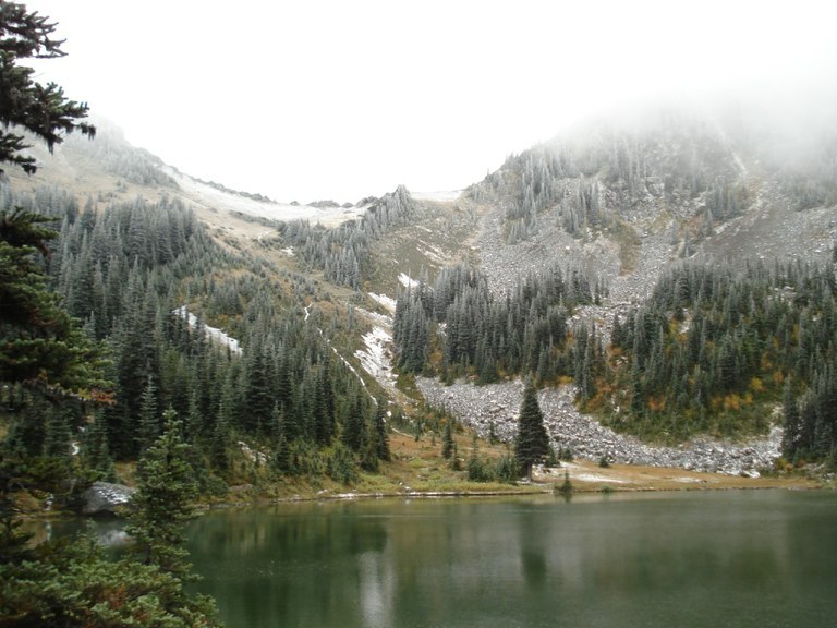
The switchbacks above Camp Windy bring you to the intersection with the Silver Lake Trail at 3.0 miles. Head over a narrow pass and down 2.5 miles to Silver Lakes.
DIRTY FACE RIDGE TRAIL
If, after making the brutal trek to the top of Townsend using the Dirty Face Ridge Trail you want to continue to another destination, toddle on down to Silver Lakes. From the summit of Townsend, head south down the main Townsend trail toward Quilcene. Not sure which one that is? Just look for the one that the most people have come up
Descend about a half mile, down several switchbacks on the south flanks of the mountain before reaching a junction signed for Silver Lake. The sign is on a tree that you may miss coming from this direction, so keep a sharp eye out to your right as you descend. The way to Silver Peak shoots off at the bend of a switchback, so instead of continuing downhill, go straight onto the trail toward Silver Lakes. From here, it's 2.5 miles downhill to Silver Lake.
Don't forget, you've got to come all the way back up and out of here, too!
A round-trip from the Dirty Face Ridge trailhead is about 14 miles.
LITTLE RIVER TRAIL
The Little Quilcene Trail offers a similar workout to the Dirty Face Ridge Trail. From the Little Quilcene Trailhead to the peak of Mount Townsend is 3.4 miles and 2180 feet in elevation gain, enough to prompt more than a few breaks to catch your breath.
After two miles, the trail intersects with the Tubal Cain Trail. At this junction, the trail moves up the north side of Mount Townsend and opens up to views to the west looking into the Dungeness and Graywolf watersheds. Head to the summit and Silver Lakes following the directions in the Dirty Face Ridge Trail.
WTA Pro Tip: No matter how you access it, consider making this trek an overnight. There is plenty of camping at the lake, and water sources along the way. Regardless of your access point, your hike will be in the double digits round trip.

 Trailhead


