
Silver Peak is among a group of hikes within close proximity to Snoqualmie Pass and the Hyak recreational area. Nearby destinations of interest include Mount Catherine, Tinkham Peak, Mirror Lake, and Twin Lakes. Silver Peak and its neighbors are reached by way of FR-9070, a gateway to the less-traveled but better-kept secrets of the Cascades. FR-9070 has its share of potholes and is generally snow-free from July until November. Approximately six miles from Hyak, FR-9070 reaches an intersection with the Pacific Crest Trail, at a saddle between Mount Catherine and Silver Peak.
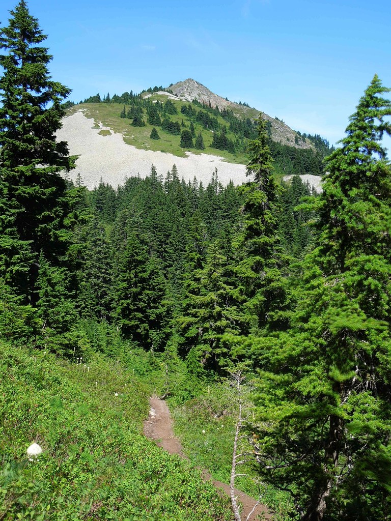
The most common direct route to Silver Peak follows the Pacific Crest Trail south for 1.7 miles and continues along a hard-to-spot side trail that turns 180 degrees and ascends the southern flank of Silver Peak. After parking along FR-9070, find the intersection with the Pacific Crest Trail (2000) at 3800 feet of elevation and head south. Salmonberry and blueberry bushes line your route. After it leaves the saddle, the Pacific Crest Trail gently gains elevation, then dips to cross the north fork of Cold Creek two tenths of a mile from the trailhead. The Pacific Crest Trail enters an alpine forest populated by noble fir, western hemlock, and mountain hemlock. The trail meanders through the forest southward past beargrass, arnica, bluebells, western columbine, foamflower, fireweed, cow parsnip, and milkweed that blossom in the summer. Bumblebees, chipmunks, hummingbirds, and pikas can be seen or heard along this section of the trail. Flies and mosquitoes can be bothersome in the summer months.
1.7 miles from the trailhead, watch closely for a turn-off up and to the right, marked with cairns. If you pass a tarn on the left, you have gone too far. The side trail climbs steadily for three tenths of a mile to Abiel Pass, a saddle between Silver and Tinkham Peaks at 4600 feet of elevation. This section requires some brief moments of class 2 or 3 scrambling. At Abiel Pass, there is a fork in the trail. A turn to the left takes you toward the impressive summit of Tinkham Peak, which towers over Abiel Pass. Turn to the right (northwest) to go to Silver Peak. As you continue to ascend, the Cold Creek valley opens below you, with Mount Catherine facing you across the valley. You will then turn north and face views of Silver Peak’s summit. The trail descends briefly before reaching the final ascent to the summit.
One-half mile from Abiel Pass the tread becomes rocky, and the incline becomes steep, gaining 600 feet over the last three tenths of a mile. Handholds are occasionally required, making for more class 2 scrambling. As you huff and puff your way to the summit, Mount Rainier rises above the horizon behind you. Blue harebells and arnica line the trail in the summer. Just as the trail levels off for a moment, deceiving you into a sense of completion, you round a bend with the summit in view. Don’t quit, as you are very close to panoramic views of Snoqualmie Pass. Stuart is to the east, and Rainier and Adams are to the south. Keechelus Lake is to the east, and Annette Lake lies just beneath you to the southwest. On a clear day, you can see north all the way to Mount Shuksan. Take care when you descend, as the rock can be loose in many places.
WTA Pro Tip: August and September are the best months for ripe berry picking. Silver Peak goes well with nearby Tinkham Peak and Mount Catherine for combination hikes.
Silver Peak

-
 Length
- 5.6 miles, roundtrip
-
 Elevation Gain
- 2,100 feet
-
 Highest Point
- 5,605 feet
At 5605 feet of elevation, Silver Peak is the tallest mountain guarding the southern wall of Snoqualmie Pass. Silver Peak has more than 2000 feet of prominence and provides commanding, panoramic views of the eastern end of Snoqualmie Pass and the surrounding mountains and lakes.
Continue reading
Parking Pass/Entry Fee
Northwest Forest PassHiking Silver Peak
Map & Directions
 Trailhead
Before You Go
Parking Pass/Entry Fee
Northwest Forest PassWTA Pro Tip: Save a copy of our directions before you leave! App-based driving directions aren't always accurate and data connections may be unreliable as you drive to the trailhead.
Getting There
From Seattle, drive east on I-90 and take exit 54 Hyak/Gold Cr. Turn right at the bottom of the exit ramp, and reset your odometer. Continue straight, crossing SR 906. The road turns into Hyak Dr NE. Continue on Hyak Dr NE. The pavement ends in 0.6 miles, and the road becomes FR-9070. Continue on FR-9070 for 4.7 miles, then arrive at the intersection with the Pacific Crest Trail (#2000), 5.4 miles after you reset your odometer. FR-9070 can accommodate 10-12 cars parking on the side of the road. There is no privy available. Take the Pacific Crest Trail #2000 South towards Stampede Pass (not north towards Snoqualmie Pass).


