There are many trails to the top of Silver Star Mountain, but your car will thank you for choosing this one as the road to the trailhead is not as rough as the one to the Silver Star Trail on the north side. This trail's starting point, known as the Grouse Vista trailhead, is on Washington State Department of Resources land, but the route quickly crosses onto the Gifford Pinchot National Forest.
Just after the trail leaves the parking lot you will arrive at a fork. The left fork is the Tarbell Trail. You’ll want to stay right for the Pyramid Rock Trail (also sometimes called the Grouse Vista Trail) which wastes no time gaining elevation; those prized views come at a cost after all. The first half mile is the steepest section of trail. After this you can catch your breath as the grade levels out and leaves the trees behind, opening onto meadows that overflow with wildflowers in the spring.
After about 1.5 miles from the trailhead you will arrive at another junction. Stay left to scoot around Pyramid Rock on a talus slope. The trail will drop a bit here before resuming its uphill cadence. At the next junction — about a mile after the last — you will want to turn left again to get on the Silver Star Trail.
After about a half mile from this last turn you will arrive at yet another junction (this time a four-way crossroads) where you will want to stay straight on the Silver Star Trail. Just one more turn to go. Just up ahead, after crossing through the four-way stop, another trail will split off to the right. Take this turn and walk the final short leg to the summit.
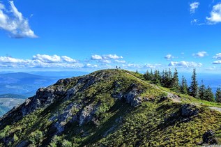
It’s well worth the climb once you get to the top and uncover the unimpeded views of, well, just about everything. On a good day you can spot the towering volcanoes of Rainier, Hood and St. Helens as well as a multitude of other peaks. And sweeping views of the Yacolt Burn State Forest stretch out and fade into the streets and buildings of Portland and Vancouver below.
If you wish to extend your trip, return to that four-way crossroads you passed through earlier and take a side trip on a different trail. A good out-and-back option is to take the trail heading east from here for just under a mile on rolling tread to the Silver Star Indian Pits, an important archaeological site for Native Americans. The only loop option that will return you to the Grouse Vista trailhead is to take the Sturgeon Rock Trail west and link up with the Tarbell Trail heading south. This loop can be closed due to logging operations so be sure to check current conditions before trying this alternative route.
All the intersecting trails on the flanks of Silver Star Mountain are a byproduct of the time when this area was popular with motorized vehicles. Now many of these 4x4 roads have been converted to hiking trails but the intersecting tangle remains. A map is a must on this hike where it's easy to lose track of all the turns.

 Trailhead