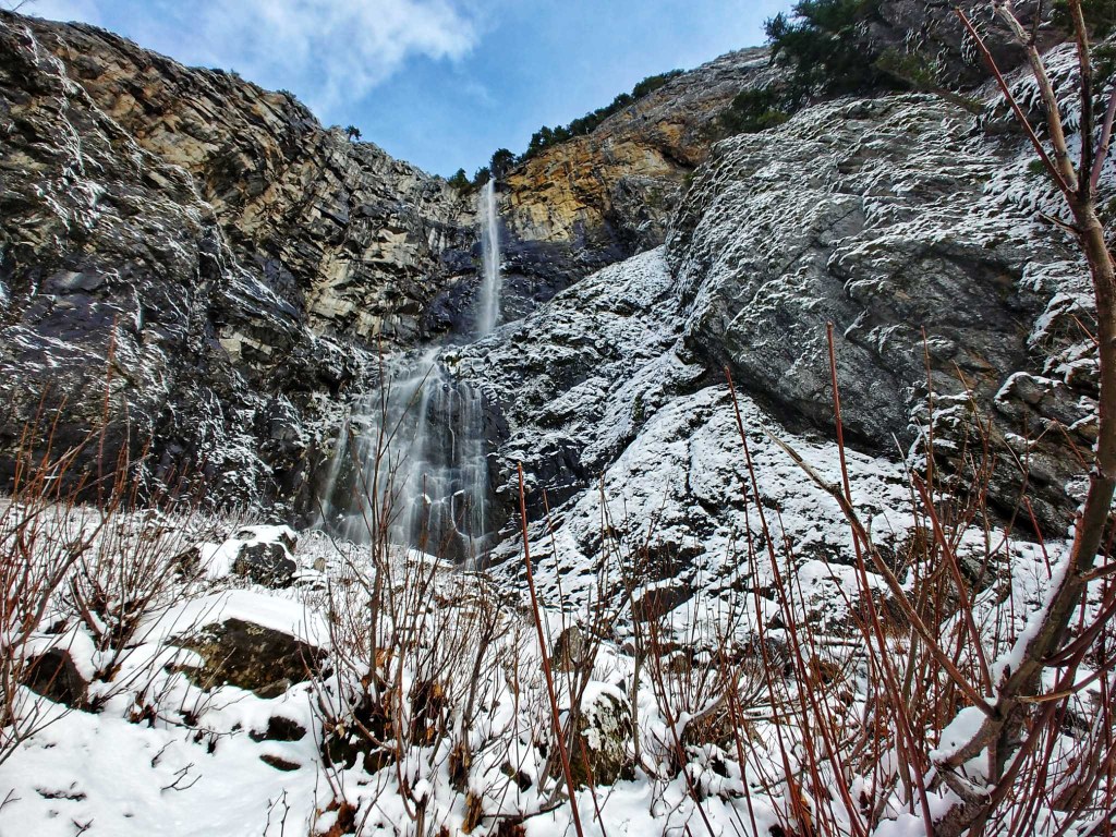
|
Copyright © Dan A. Nelson/The Mountaineers Books Snoquera Falls Loop
This lush, moss-laden forest is reminiscent of Olympic Peninsula rain forests, for good reason. The western foothills of the Cascades can get twice as much annual rainfall as the Puget Sound area, making the low forests of these regions wet, mossy, and rich in plant (and animal) life. In short, a rain forest. This trail is short, but scenic--perfect for late-season hikes when the days are short and hiking time is at a premium. The trail leads past the base of a small cascade on Snoquera Creek, best viewed in late spring and early summer when the deep snowpack is melting, forcing impressive amounts of water over the rocky falls.
The trail angles into the forest on the northeast side of the highway, climbing gradually through the nearly dripping cedar and hemlock forest and sweeping carpets of moss--in the spring spotted with splashes of yellow and white (skunk cabbage and trillium), and in the fall with gar-lands of red and umber (Oregon grape and drying ferns). The trail steepens after the first 0.5 mile as it veers right at a trail junction. From the junction, the trail slants up the lower slope of Little Ranger Peak. Big-leaf maples and a few scrub oaks now fill the spaces between the hemlocks and Douglas-firs. At 1.2 miles the trail drops into a little rocky basin, filled with maples, and crosses a small stream below the fantail waterfall on Snoquera Creek. This pretty falls can be roaring in the spring as the winter's snow-pack melts, but it can turn off, leaving just a trickle, later in the fall. For the full experience, plan to visit at least twice to see the difference in water levels and how it affects the whole basin. From the waterfall basin, the trail continues north, rolling along the base of a steep, rocky slope for 1.5 miles before descending a few short switchbacks to a junction with the lower valley trail. Turn left and follow this trail south 1.3 miles, passing the Boy Scout camp before returning to your starting point.
Driving Directions:
From Enumclaw drive east on State Route 410 (Chinook Pass High-way) through the town of Greenwater. Continue past the Dalles Camp-ground and find a small parking area on the left (north) side of the highway, just a few yards south of the Camp Sheppard Boy Scout Camp. Recent Trip Reports
Hiked here recently?
Submit a trip report!
There are
77
trip reports for this hike.
See all trip reports for this hike.
Snoquera Falls Loop
— May 19, 2013
— bockdip
Day hike
Expand report text
Hide report text
Read full report
Found the trailhead without difficulty, thanks to previous postings: turn in at Camp Sheppard, then...
Found the trailhead without difficulty, thanks to previous postings: turn in at Camp Sheppard, then turn right to the parking lot. The guidebook trail directions are still confusing -- veer right at the first trail junction is correct, but there is a second one where you must go left.
C-ro's post is correct -- the distance and elevation gain in the guidebook are way off. My GPS measured 4 miles and about 800 feet cumulative elevation gain, to a maximum elevation of just over 3000 feet (vice 6 miles, 2800 feet and 5000 feet in the guidebook). At least the web version of this trail description should really be corrected. Going counterclockwise, the trail up to the falls is in excellent condition. Crossing the stream below the falls is a little tricky -- the rocks provide footing, but they get wet and slippery, particularly on a damp day like today. Heading down the other side, there are a number of rock slope crossings where you need good boots and careful footing. Despite the damp day, the trail was basically dry, with no snow in sight. Day hike
Features:
Wildflowers blooming
Expand report text
Hide report text
Read full report
with photos
We enjoyed a lovely hike to Snoquera Falls today.... once we found the trail, that is. Following the...
We enjoyed a lovely hike to Snoquera Falls today.... once we found the trail, that is. Following the directions in the Day Hiking Snoqualmie Region book, we found the little parking area just south of the Boy Scout camp, but then wandered up and down the trail running parallel to the highway without finding trail #1167 to Snoquera Falls. Finally we backtracked to the road in to the Boy Scout camp and there found a large parking lot and trailhead. Apparently this is the (relatively)NEW trailhead. So, note that one should turn off Hwy. 410 onto the Camp Sheppard Rd., where you will then find the parking area, restrooms and trailhed to your right. The falls were in their full roaring glory and made a wonderful destination and lunch spot. We also tried to locate the trail to Skookum Flats across the highway. We did find a trail down to the river, but no way to reach the trail on the other side. Appears that the old suspension bridge may have washed out.
Snoquera Falls Loop
— May 07, 2013
— GratefulWanderer
Day hike
Expand report text
Hide report text
Read full report
This was the third day in less than a week doing trail maintenance with WTA on the trail leading to ...
This was the third day in less than a week doing trail maintenance with WTA on the trail leading to Snoquera Falls. The hike in each day was easy going and dry. The last day was spent finishing a rock wall in an area of the trail that passes through a small rock slide. The trail was starting to erode, but we were able to build up a supporting rock wall and make the trail look as if nothing had happened.
Snoquera Falls Loop
— May 05, 2013
— c-ro
Day hike
Expand report text
Hide report text
Read full report
Nice hike, but not even close to 6 miles or 2800 feet of elevation gain. I was expecting this hike t...
Nice hike, but not even close to 6 miles or 2800 feet of elevation gain. I was expecting this hike to take some work, but it was pretty easy. I would just guess that it's about 4 miles and w/1000 ft of elevation gain.
Snoquera Falls Loop
— Apr 26, 2013
— violentoceans
Day hike
Issues:
Mud/Rockslide
Expand report text
Hide report text
Read full report
Trail was mostly dry and totally clear of snow. There are a lot of trails snaking around the area, s...
Trail was mostly dry and totally clear of snow. There are a lot of trails snaking around the area, some marked some not, which can make things tricky initially. Once you're on it, it's a nicely groomed trail with low grades. Past the falls there were a couple of rockslides that sort of obliterate the trail for 20-50' stretches.
Also, this was a really quick hike. I think six miles may be a bit of an overestimation. |
![]() Snoquera Falls. Photo by 'Goofy Gamine.'
2010, 2011, 2012
Map it
|
Document Actions
- Email this page
- Print this
- Share


