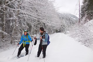
You are here: Home Find a Hike Hiking Guide Snow Lake Snowshoe

Snow Lake Snowshoe


Featured In: Snowshoe Routes - Washington, by Dan A. Nelson.
Buy the full book, including maps, elevation profiles, photos, and more:

» REI » Amazon

A portion of all book sales from the links above benefits WTA and helps protect and maintain our trails.

Snow Lake may be the most popular wilderness trail in the Pacific Northwest. From June through September, it gets thousands--maybe tens of thousands--of hiker visits. But those who take the time to check avalanche snow conditions and closely monitor avalanche dangers can find a safe time to trek this route. The route begins by heading to Source Lake (Route 49), but pushes on past that easy-to-reach day-hiking destination and climbs steeply to crest the saddle separating Snow Lake from the Snoqualmie River drainage. This makes for a rigorous outing, but one well worth the effort--especially for those seeking a winter camping destination.

From Alpental, follow the route to Source Lake (Route 49), staying on the west side of the river basin. From Source Lake, swing north and start climbing the increasingly steep slope below Chair Peak, angling north and east up the slope. At about 3 miles, you'll find the slope tapers off and you enter a broad, tree-dotted meadow atop a broad saddle between Chair Peak and Snoqualmie Mountain. Stop and catch your breath here as you peer out at the surrounding glory. Denny Peak lies to the south, flanked by The Tooth, Bryant Peak, and Chair Peak to the west. To the north, a high ridge links Chair Peak to Snoqualmie Mountain on the northeast, which is in turn flanked by Lundin Peak, Red Mountain, and finally Guye Peak to the southeast.

Due north, just a few hundred feet below you, lies the long, flat oval of Snow Lake. You can descend to the lakeshore to find camp, or find a comfortable place to pitch your tent on the ridgeline, where the views are far better. Just find a nice flat in the lee of a stand of trees and you'll be warm and comfy. To continue your outing, and to gain a panoramic view of the basin, head east from the lake and climb to the low ridge above the lake, exploring to your heart's content.

Author’s Rating: More Difficult
Some previous snowshoe experience helpful. Some winter survival skills recommended (basic knowledge of avalanche evaluation, emergency shelter construction, etc.). Elevation gain is usually less than 1000 feet with a gradual slope.
Driving Directions:

To get there, from Seattle drive east on Interstate 90 to exit 52 (Snoqualmie Pass, West Summit) and turn north, crossing under the freeway. Continue north to the end of the road at the Alpental Ski Area parking lot.

Improve or add to this guidebook entry

Note: the description and driving directions for this Mountaineers Books entry are copyrighted and can't be changed.

Recent Trip Reports

Hiked here recently? Submit a trip report!
There are 30 trip reports for this hike. See all trip reports for this hike.
Snow Lake Snowshoe — Feb 10, 2012 — raBBit
Snowshoe/XC Ski
Expand report text Hide report text
Avalanche danger low so headed out to Snow Lake. Travel was easy as temperature was around 40 degrees, road was...
Avalanche danger low so headed out to Snow Lake. Travel was easy as temperature was around 40 degrees, road was clear and parking was easy at the Alpental parking lot. Started on the trail at 8:30 AM and ran into only one person. Crusty snow got somewhat softer climbing higher. Stomped down trail is easy to follow but dwindles when higher. Light snow fell on and off and fog became thicker higher on the trail. Glad I had grey tint eyeshades to increase contrast to cross open areas especially in the fog.
Read full report with photos
Source Lake Snowshoe, Snow Lake Snowshoe — Jan 30, 2012 — Cruiznbye
Day hike
Expand report text Hide report text
A snowshoe hike to Source Lake and then up to the top of the ridge overlooking Snow Lake. About...
A snowshoe hike to Source Lake and then up to the top of the ridge overlooking Snow Lake. About 7 miles round trip and total elevation gain of 1500’ for the route we took to Source and then the ridge climb. The roundtrip to Source is about 3.5 miles and 700’ of elevation gain.

We parked in the upper parking lot at Alpental at Snoqualmie Pass, arriving later than usual at 11:30am. Already about 8 cars in the lot. There was about 6” of fresh snow on the road and we actually needed to put chains on our car to get to the lot after getting stuck halfway up. We could have parked at the lower, first lot and walked, but we had the chains and decided we’d save our energy for the trail proper.

Trail starts at the North East corner of the parking lot and is easy to see (no signs). It is a broad snow road and passes a water tower soon along the way. Not too far in (less than 1/2 a mile) the road will turn down a hill steeply and usually (as this time) there is a split in routes. Going down the road/hill will keep you close the creek (North Fork of the Snoqualmie) up to the waterfall area where you’ll climb steeply to gain about 600’ before reaching the top of the waterfall ridge and continuing on. The other route will stay left at the junction and traverse higher along the Western slopes of the valley (underneath Bryant, the Tooth, etc). This is the route we took as the snow was stable and avalanche danger had passed. The exposed slopes are NOT recommended when avalanche condition are present. We passed through a few areas of avalanche debris from the previous cycle.

At about 1.75 miles you’ll reach Source Lake. It is nearly all covered in snow and it is so small that it looks like nothing more than a creek poking through the snow cover in a couple places. It’s at the head of the valley and the large snow bowl below Chair Peak will be just beyond it. This is a good turn around point for a good easy snowshoe trip.

Weather was good (cold and snowy) for traveling on, so we circled Source Lake and headed up the Eastern side of the snow bowl. It is a steep climb and the snow was wet powder 24” deep. We angled and switchbacked up the slope through the trees and finally attained the ridge at about 4450’ in elevation. From the “snow bowl” approach we traversed across the top of the ridge to the East (right) to the Snow lake overlook, which is just a mound of white.

No views as fogs and clouds filled the lake basin. 3 other parties of snowshoers, and 1 group of BC Skiers (12 of them) were met on the trail. Poles and Snowshoes on the trail to Source needed (though if the trail is packed down you could get by without snowshoes. Ice Ax and/or poles and snowshoes on the ridge climb were used.

Be sure to check snow/avalanche conditions carefully before climbing past Source Lake to the ridge as there is high potential for avalanche danger here.

Photos of hike here: http://www.flickr.com/[…]/

Read full report with photos
Snow Lake Snowshoe — Dec 23, 2011 — JohnStarky
Snowshoe/XC Ski
Issues: Snow on trail
Expand report text Hide report text
Started from the last parking area at the end of the Alpental road. The trail was compacted and well marked...
Started from the last parking area at the end of the Alpental road. The trail was compacted and well marked initially. At about the 1/2 mile there was a large fork in the trail, the smaller one on the left being the most direct path to Post Lake, while the one on the left would lead to the junction for Snow Lake. We ended up snowshoeing the entire loop, which with breaks and a few young first-timers was about 5 hours in total. There is plenty of snow up there, and off the main trail there is plenty of powder to explore. We didn't see any major avalanche areas, although the grades along some of the trail sections could definitely get tricky if the conditions were right.
Read full report with photos
Snow Lake Snowshoe, Gem Lake, Wright Mountain — Dec 04, 2011 — Big Daddy P.
Day hike
Issues: Snow on trail
Expand report text Hide report text
I wanted to get back out to this area seeing how a couple of weeks back I tried this hike...
I wanted to get back out to this area seeing how a couple of weeks back I tried this hike and was caught up in first major amount of snow this year and turned back just below Gem lake. The weather today was much better, started with some fog, then the sun came out to brighten things up. I was able to get Alex out on the trail with my dog (Pepper),Isiah and myself. It's been a couple of weeks since Alex put his boot to the trail but he came in with some gusto. The trail to snow lake saddle was well worn, no need for snow shoes till we dropped down to the lake. Once we got to the lake we crossed over the frozen lake to the far side and went up the hill side to Gem lake, climbing up thru the trees like Alpine Apes. We saw no other trace of anyone up this way or at Gem lake,only some rabbit prints.Gem lake was frozen over as well and the snow good for walking on. We made our way up Wright mountain and had lunch then went down the other side to follow the rim around the lake to meet up with our trail in. We did some sliding on our way out which saved some time. We had some fun and adventure along the way. We also lost an ice ax somewhere on the way out, if anyone sees it and wants to return drop me note. I'll see you on the mountain and you will know it's me when you here me howl!!! Gorillaz in the Mist.
Read full report with photos
Source Lake Snowshoe, Snow Lake Snowshoe — Mar 27, 2011 — timezra
Snowshoe/XC Ski
Issues: Snow on trail | Avalanche danger
Expand report text Hide report text
Open fields of recent avalanche debris on the lower slopes of Snoqualmie Mountain provide a constant reminder that, even on...
Open fields of recent avalanche debris on the lower slopes of Snoqualmie Mountain provide a constant reminder that, even on a day of low avalanche risk, the route to Snow Lake requires constant reappraisal.
We started from Alpental at 8am on the northeast side of the creek to Source Lake, but soon found ourselves ascending too high too quickly up to a viewing area with a snow-carved double bench that would have provided a picturesque scene of the valley below on a clearer day. The first few chute crossings felt solid, but we were finally turned back at a flume with steep, soft sides. On its far side was an exposed, steep and corniced ledge, and the only other suitable crossing we could see was far below.
After backtracking and turning around at another steep, open slope, we finally retraced our steps close to the start of the trail, where we stayed on lower ground and navigated a path around the wide drainages of chutes we had crossed above and through the lower forest where we were greeted by hungry Whiskey Jacks.
At the plateau overlooking Source Lake, we saw groups of snowshoers, skiers and snowboarders, many of whom had followed the southwest side of the creek and had been listening to slides on that side of the ridge throughout the morning. We lunched on cucumber, spinach and hummus sandwiches with warm tea for the final northwest push to the divide on the eastern shoulder of Chair Peak and down to Snow Lake.
As the afternoon warmed, the more consolidated snow of the morning became a slushy oatmeal. With the vertical slope of the last fifty-foot pitch to the shoulder at Chair Peak's base, the snow began to feel particularly unstable and wet, and new steps would have been precarious and loose. The two climbers who had been to the top ahead of us said the obscured views down were not worth the effort of those last few feet. Since we were at our turn-around time of 2:30pm, since the slopes were warming, and since we were already exhausted from breaking trail (and in my partner's case, post-holing), we turned our backs on Chair Peak.
The steps we pounded on the way up provided little support and we easily triggered small, loose, wet slides as we bounded directly down towards the Source Lake basin and the route to Alpental. After a few glissade attempts on steeper sections of the forested lower trail with soft landing zones, and after a quick side trip to a small waterfall off the main creek, we were back at our car a little before 5pm.
Read full report with photos
snow lake terpene.jpg
Snow Lake. Photo by terpene.
Location
Snow Lake (#1013)
Snoqualmie Pass -- Snoqualmie Pass
Mount Baker-Snoqualmie National Forest, Mount Baker Ranger District
Statistics
Roundtrip 10.0 miles
Elevation Gain 2000 ft
Highest Point 5100 ft
Features
Lakes
Mountain views
Ridges/passes
Established campsites
Guidebooks & Maps
Snoqualmie Pass No. 207

Improve or add to this guidebook entry

Note: the description and driving directions for this Mountaineers Books entry are copyrighted and can't be changed.

Map it
Red Marker Snow Lake Snowshoe
47.4453502 -121.4234934
(47.4454, -121.4235) Open in new window
Document Actions
  • Email this page
  • Print this
  • Share
Log in


Forgot your login name or password?
New user?


Email Newsletter

Get Trail News each month hiking tips, trail ideas, action alerts.

Connect with us

Facebook_icon2 twitter_icon RSS_icon

Featured Member
Footer
powered by Plone | site by Groundwire and served with clean energy