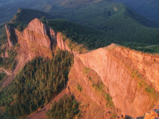
Table Mountain
Table Mountain's dramatic south face and pyramid profile beckon the adventurous hiker ready for a strenuous climb that is good training for summer summit attempts to come. The top features one of the best panoramas of the Columbia River Gorge, as well as views of Mt. St. Helens, Rainier, Hood and Adams. Carry a guidebook with good route information as there are a couple of options to the summit and signage may be lacking.
The standard route begins at the Bonneville Trailhead off of Hwy 14 opposite the Bonneville Dam. From the trailhead follow the Tamanous Trail #27 for 0.6 miles to the junction with the PCT. Turn left onto the PCT and follow it NW for 1.9 miles to Gillette Lake. Continue on the PCT for another 5.5 miles to the junction with the Eastway Trail (also known as Heartbreak Ridge). A second route to the summit off of the PCT, the Westway Trail is another 0.4 miles further. Both Eastway and Westway trails join near the summit to the final 0.3 mile Overlook Trail that leads to the southern face of the mountain. Many hikers make a loop by ascending the Eastway Trail and descending the Westway Trail. Portlandhikers.org has a hiking guide with a detailed trail log of this area. A popular, less difficult version begins from the Bonneville Hot Springs Resort and Spa and is described in 60 Hikes within 60 miles of Portland, 3rd Edition, Menasha Press. It shortens the roundtrip distance by about 5 miles. Since this option includes a power line access roads and non-designated trail, I highly recommend that you hike it with someone who knows the route, or with guidebook in hand.
Driving Directions:
From Seattle Take I-5 south to Vancouver. Then take Hwy 14 east, Continue past Beacon Rock State Park. At mp 39.8 look for the Bonneville Trailhead on the left, opposite Bonneville Dam. It is approximately 40 miles east of Vancouver. Recent Trip Reports
Hiked here recently?
Submit a trip report!
There are
6
trip reports for this hike.
See all trip reports for this hike.
Day hike
Expand report text
Hide report text
Read full report
with photos
I parked at Bonneville Hot Springs and followed the directions in the Romano guide to ascend the Eastway trail and...
I parked at Bonneville Hot Springs and followed the directions in the Romano guide to ascend the Eastway trail and descend the Westway trail. Bringing a copy of the guidebook map is strongly suggested and you might want to mark junctions with some sticks to avoid hiking a couple extra miles in the dark like I did. Although the ground was frozen most of the way, there was only a dusting of snow near the top.
The wind was blowing from the east about 30 mph at the trailhead, and by the time I started down the Westway ridge at sunset, it sounded like a freight train coming through the trees. At a couple spots where the trail is next to cliffs, I got down on my butt and crawled/slid down the steep rocky trail because I was afraid I would get blown over the side. The Eastway section is steeper and involves a talus slope, but at least one would only risk getting knocked down by a strong gust. I definitely plan to go back when conditions are more benign in order to enjoy the views and the simple joy of walking upright.
Pacific Crest (South Cascades) #2000,Table Mountain #18,Dog Mountain #147
— Dec 30, 2006
— Ken and Juliet Mondal
Day hike
Issues:
Blowdowns | Snow on trail
Expand report text
Hide report text
Read full report
My wife and I decided to find some ""year-round"" hiking in order to
celebrate the New Year. We thought the Gorge...
My wife and I decided to find some ""year-round"" hiking in order to
Table Mountain #18
— Mar 31, 2005
— toadlicker
Day hike
Issues:
Snow on trail
Expand report text
Hide report text
Read full report
I parked at the Bonneville trailhead, but if anyone is interested, one can cut several miles of hiking by...
I parked at the Bonneville trailhead, but if anyone is interested, one can cut several miles of hiking by taking the trasnmission line road. Most of this hike follows the PCT, with some camping options at Gillette Lake, and a nice camp site about 1 mile beyond the lake at a creek crossing. The EAST trail up Table Mountain is closed, and for good reason. The west trail is the only trail to the summit now, and it's easier and more scenic anyway. About 350 feet shy of the summit the snow begins (as of March 31) but the trail is easy to follow and fairly safe (if the snowline is a few hundred feet lower, the trail could be very dangerous is a slip occurs).
Table Mountain #18
— May 26, 2001
— misterling
Day hike
Expand report text
Hide report text
Read full report
We started by the slough, near the power line access road, rather than at the official USFS trailhead off...
We started by the slough, near the power line access road, rather than at the official USFS trailhead off WA 14. Starting here cuts out at least four miles of slogging through clear-cuts and logging roads from the hike; it also cuts out the insidious USFS Demo Fee. (Editorial content: Why are hikers willingly paying this fee when logging, mining, and grazing are all subsidized by below market costs AND some recreationists like hunters and boaters do not pay' ) We followed the power line road uphill to some flagging leading east around a beautiful meadow. Looking north across the meadow, we could see a striking rock pulpit below Table Mt. Continuing on east, we struck an old jeep track heading uphill, north toward the PCT. Turning NW on the PCT for a mile, we soon reached the start of the ""eastway"" trail, marked by a broken heart wooden sign. The trail commenced a steep upward section through timber for about a mile, breaking out of the timber near a saddle, where we donned more clothes. The wind was howling. Then we began the last steep section, Table Mt. summit looming above through lowering clouds, following a serpentine course up through grasses and wildflowers. The summit was so cold, we only tagged and returned the same way. Trail in good shape. No snow. Having hiked both ""eastway"" and ""westway"" trails to the summit, I'd say that the ""westway"" is more scenic and perhaps easier up. They are both ""quad busters"" on the way down.
Table Mountain #18
— May 19, 1999
— Carl F. Prenner
Day hike
Issues:
Snow on trail
Expand report text
Hide report text
Read full report
A light breeze and 65 degree weather made this 9-mile loop trip a delight compared to what one can...
A light breeze and 65 degree weather made this 9-mile loop trip a delight compared to what one can sometimes experience on this trail. The scotch broom during the first 300' of trail provides a gauntlet of allergic aroma to deal with as you leave the cars at the Columbia River slough trailhead near N. Bonneville. The broom is heavy stuff until you enter the woods; then, the stretch to the next road/trail is muddier than normal. We opted to follow the PCT as it contours up and around to the base of the SW Ridge of Table Mtn. Blowdowns were nonexistent. The 1,000 feet up the ridge is rocky, snow-free, and straight-forward until you reach the summit plateau. The snow there exceeds 5 feet still in places as one traverses eastward on the summit to the rocky outcropping above the cleavage point which dropped the mass of earth now called Bridge of the Gods. The normally gosh-awful descent by trail down the east side of the south-facing bowl to the Heartbreak Trail was a pussycat. The brush has not had time to spread out for the summer and the tread has little in the way of ball-bearing rocks and pebbles usually encountered. Descending this way must save at least 30-40 minutes over retracing the ridge. Only 2 other hikers besides our party of four.
Table Mountain
— Jun 14, 1998
— Carl F. Prenner
Day hike
Expand report text
Hide report text
Read full report
From the North
Bonneville slough, we headed up the transmission line road through all the scotch broom into the real...
From the North |
Morning light on the south face of Table Mountain. Tim Lawson
|
Document Actions
- Email this page
- Print this
- Share


