
A very challenging hike to a lookout in the Mountain Loop Area. Hike a road, then along a trail to gorgeous Goat Flats. From there, the route kicks up in difficulty as it accesses Tin Can Gap. The final push, up ladders rebarred into rock is exposed, and surefootedness is an absolute must at the lookout.
After a long road walk, visitors will start off with a 2.5-mile trek to Saddle Lake. The trail here is usually soggy, past visitors report it feeling like hiking up a stream. The lake is pretty, but hemmed in tightly with trees.
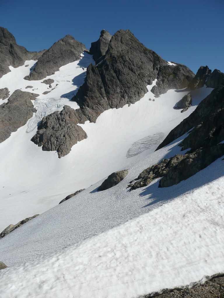
The next two miles to Goat Flats, you start breaking out of the trees and are quite pretty. Goat Flats is a gorgeous meadow on top of a ridge. To the north are views down into a valley and a number of very nice campsites, but make sure you have something to keep the bears out of your food as bears are known to frequent the area. Past here, you're heading to Tin Can Gap, and the more technically-challenging part of the trip begins.
The trail to Tin Can Gap follows the south side of the ridge and is mostly above the tree line. Don't attempt to go past Tin Can Gap if you don't have climbing equipment and routefinding experience. There have been multiple search-and-rescue missions here in past years.
Year-round, ice axes are a must and crampons and a rope should be considered to travel past Goat Flats. A small but quite steep snowfield must be crossed or skirted on the north side of the ridge. Late in the season you might be able to follow a small moat around to the high side for safety. If you cross the snowfield directly, you may have to chop steps in or cross wearing crampons. The rock on the far side can be smooth, so be prepared to look for small hand and footholds. The trail will then cross the ridge and continue on the south face of the ridge.
After a bit, the trail will cross back to the north side of the ridge, and you will run into the top of the Queest-Alb glacier. Most people continue onto the glacier and descend to where the trail crosses back to the south side of the ridge, but this can be extremely slippery and dangerous. If you slip a best-case scenario is to slide about 200 feet into rocks. A worst case scenario is to miss the rocks and continue down several thousand feet to the crevasses at the bottom of the glacier.
Late in the season, you can keep off of the glacier by staying in the moat between the top of the glacier and the rock. Finding the entrance to the moat can be a bit tricky in bad weather.
Past the top of the glacier, the trail traverses back to the south side of the ridge and continues until you get to a snowfield below the summit. After crossing the snowfield you scramble on the rocks until you find the ladders up to the lookout. The three ladders are pure vertical.
If you have made it this far, you are rewarded with a very nice old fire lookout, maintained by volunteers with the Everett Mountaineers. It has incredible views and room for a few people to sleep, but nowhere to camp outside the structure. There is even some old fire spotting equipment.
If the lookout is closed, please respect the closure and do not attempt to enter. Camping is available back at Goat Flats, so plan your arrival at the lookout early in the day so you can turn around and camp safely elsewhere if it is occupied.
Note: Please be aware that drones are prohibited from being launched, landed or controlled in the Boulder River Wilderness, which includes the trail and the lookout. Read tips on Responsible Recreational Use of Unmanned Aircraft Systems (UAS) on National Forest Systems Lands on the Forest Service website.

 Trailhead