
This is a classic Olympics river hike without the crowds, and it's downhill all the way to your destination.
This inverted hike starts you out easy, cruising down a gentle grade through mossy woods with some peek-a-boo views of surrounding peaks. Late spring provides a stunning rhododendron show, but you’ll find flowers throughout spring and summer, and gorgeous colors in fall.
Chances are, you’ll also find solitude along this trail, and Slab Camp in Duncan Flats is a great stopping spot for lunch. Watch dippers bob along the river shore and dive for fish and insects in the current. Continuing on, arrive at a junction with the Gray Wolf Trail. Turn right. Now, you're hiking alongside the green, rushing Gray Wolf River.
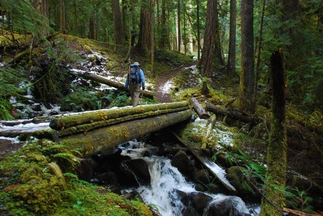
After lunch, continue to the impressive bridge just past Slab Camp. If you want to wander farther, there is Camp Tony, then the trail ascends through more mossy woods studded with rhodies in season, when in season.
Just shy of 6 miles from the trailhead, there is a junction with the Olympic National Park Boundary. Hikers can continue on and on (though pups can't proceed past here), hiking the Upper Gray Wolf Trail. However, the hike to the bridge is a lovely one, the perfect length for a day hike, and offering delights to eye, ear, nose, and during berry and mushroom seasons, the mouth.
WTA Pro Tip: If you have time to explore the Dungeness area, stay a night or two at Dungeness Forks Campground or the historic USFS Louella Cabin and indulge in one or two of the many nearby hikes in the Olympic National Forest and Park.
Slab Camp Creek and Gray Wolf River

-
 Length
- 5.5 miles, roundtrip
-
 Elevation Gain
- 1,100 feet
-
 Highest Point
- 2,540 feet
This is a classic Olympics river hike without the crowds, and it's downhill all the way to your destination.
Continue reading
Hiking Slab Camp Creek and Gray Wolf River

WTA worked here in 2023, 2022, 2021, 2020 and 2019!
Map & Directions
 Trailhead
Before You Go
Parking Pass/Entry Fee
NoneWTA Pro Tip: Save a copy of our directions before you leave! App-based driving directions aren't always accurate and data connections may be unreliable as you drive to the trailhead.
Getting There
From South:
Take 101 to Louella Road just south of Sequim Bay State Park. Turn left at the T onto Palo Alto Road. After about 6 miles, take a right at a junction onto FR-2880. The road goes down steeply to cross the river. In just over 1.5 miles, turn right onto FR-2870 (signed for Gray Wolf and Slab Camp trails). After about 4.5 miles, stay straight to be on Slab Camp Road (do NOT turn left onto 2878 or other unmarked roads). Shortly, turn left onto FR-2875. Take note that the sign is sometimes knocked down or obscured. Follow FR-2875 about 3.5 miles to the end and an open parking area for Slab Camp & Deer Ridge Trails.
From Sequim/North:
Travel 2.5 miles west of Sequim on US Highway 101. Just after crossing the river, turn left on Taylor Cutoff Road. Bear right after 2.5 miles onto Lost Mountain Road. In another 2.5 miles, take the left at the fork to Slab Camp Road. After another mile, turn right onto FR-2875. Please note that shortly before the 2875 turn, there's a small sign saying Gray Wolf Trail is straight ahead; this sign is for Lower Gray Wolf. Follow FR-2875 about 3.5 miles to the end and an open parking area for Slab Camp & Deer Ridge Trails.