Trip Report
East Fork Foss - Necklace Valley, Alpine Lookout & West Fork Foss River and Lakes — Saturday, Sep. 13, 2008
 Central Cascades > Stevens Pass - West

West Fork Foss R #1064
Foss Lakes High Route
Necklace Valley #1062
9/13-15/08
perfect weather, salm, sunny, brisk east wind at night
You can do this loop in 2 days, but more fun in 3. If the weather is clear, you won’t want to hurry in the high country. I parked at Necklace Valley and hiked the road to the West Fork. You want the 7.5’ Big Snow Quad; a 15’ map is inadequate in poor visibility.
West Fork Foss R #1064
==========
Note: early season posters, please include detailed info on the river crossing, as this is the crux of this route and that’s what your readers will need to know. The Alpine (Foss) Lakes High Route is more pleasant when it’s under snow, but I avoided it earlier this year because I was unsure of the river crossing and postings were not very informative. Until the river is bridged, people need to know if this can be crossed at high water.
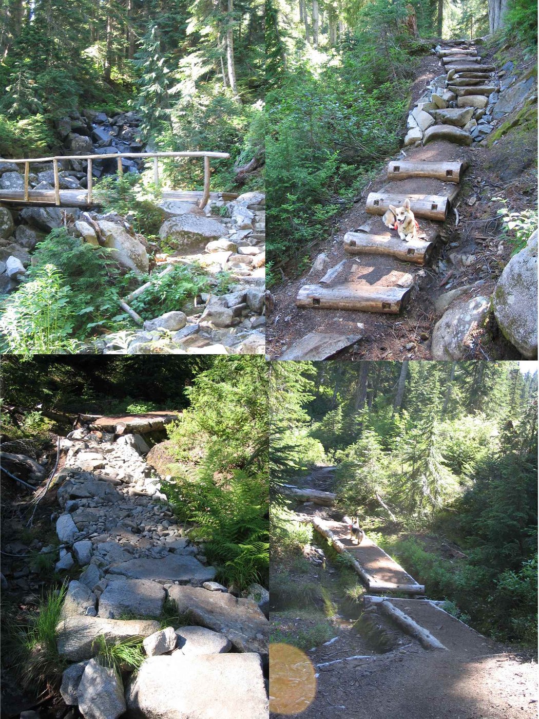
The first part of this trail is the worst: 1/4 mile or more of rocky overflow channel, a big washout and a river crossing that would be difficult (impossible?) at high water. Don’t let this stop you. It gets much better.
I was able to clear a lot of blowdown by simply moving it out of the way – stuff people had been clambering over for years, apparently. Duh. If you shove a big log or rock off the trail, make sure there’s no switchback with people below. A collapsible hand saw works wonders. It’s better now.
In the Copper-Big Heart section, a lot of recent, beautiful rockwork, puncheon and turnpike speed the trail. Nice work, thanks! Much effort has been put into this trail.
Foss Lakes High Route Sept. 2008
==========
Unseasonally hot weather after recent rain plus this year’s heavy snowpack meant unseasonally abundant bugs. Mosquitoes were vicious at Chetwoot Lk. outlet and bothersome on a hot Sunday at Tank Lakes, where I hung my food to keep it away from the insects. They must’ve been murderous in Necklace Valley! I had no tent or DEET and was saved by high camping and nighttime east(!) winds.
From Chetwoot, go high, straight east up the talus, then traverse left under cliffs. One could camp on the first rib (N of Pt 6077), flat with a stagnant but filterable pond. Much more snow than last year at this time. If it’s very dry and you must use the Iron Cap Lake water, bring a silt filter and water bag. Remarkably, there were snow patches high on the N. ridge of Iron Cap (utterly dry 9/2007). I bivvied there near 6200’ in clear warm weather with a full moon. Weather permitting, carry water up high and enjoy the view.
The traverse to Iron Cap Gap is straightforward… in good visibility. Last year, in poor visibility and rain, it wasn’t. West-to-east, climb up to about 5850’, then drop down to a flattish spot about 5500’, then traverse SSE. The route is cairned, perhaps over-enthusiastically.
Necklace Valley #1062
==========
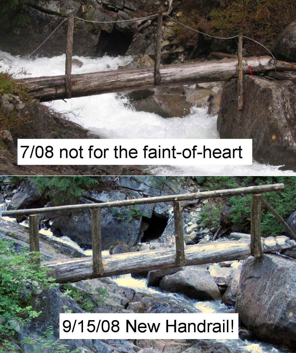
For the first several miles, this trail is a cruise. Past the river crossing, it is not, climbing steeply into the hanging valley. The bad news: one of my favorite trails is admittedly rocky, rooty, muddy, and steep. Needs a lot of work. The good news: it’s had some. Thanks! No blowdown (except 1 monster), and some of the worst spots have been fixed. Brand-new handrail at the upper log crossing, yay! Some beautiful rockwork. Moist, the upper valley is notorious for insects. The cabin has a plaque with a punctuation error charmingly cast in bronze. The upper cirque has immense solid granite walls – there were huge glaciers here.
A year ago, the huckleberries were a serious impediment to travel. This year: none. The poor bears must be starving.
Ascent to either La Bohn Lakes or Tank Lakes would be more pleasant in early season on snow (the chute up to La Bohn Lakes requires an ice axe; I’m not sure about the Tank Lakes route). Late season, very rocky: if you like rock-hopping, you’ll love the ascent to Tank Lakes, which follows the medial moraine, and this rockpile doesn’t look like it’s been inactive for long. It’s a huge, barren, desolate, magnificent cirque. If you can get up to Tank or La Bohn Lakes in one day, do so and avoid the bugs down below, but you’ll need an early start and save energy for that last long push. It is worth it. Ascent of Hinman best in early season as a snow climb with ice axe (only really needed to get to La Bohn Lakes); late season, it's a rockpile.
Tank Lakes is a beautiful topographic oddity: granite (granodiorite, quartz diorite, whatever) in layered terraces with vertical jointing planes. Climbing up from below, where you can’t see the water, it’s oddly reminiscent of the SE Utah desert, but greys instead of reds, granite instead of sandstone, slickrock sculpted by glaciers instead of wind and water, subalpine fir instead of juniper, stunted by altitude instead of aridity. Ascend to the highest terrace, where you’d least expect it, and poof! a perfectly clear, shallow lake (nobody told it that lakes belong in the bottom of basins). Weird.
Please don’t even think of coming up here if you’re going to do stupid stuff like build fires, make toy cairns, camp (or walk) on vegetation, or move rocks around. If you move a rock from where Nature left it, that sticks out like a sore thumb. This is very delicate country. Please don’t even leave footprints.
Day 1
6:55 AM Leave Necklace Valley trailhead
7:45 AM Leave W Fk Foss trailhead, 11 cars
8:30 AM Crossed river (very low water, easy)
12:15 PM Leave Copper Lake after break
3:00 PM Leave Big Heart Lake
5:00 PM Chetwoot Lake (bugs fierce). Go east, high up on talus.
Bivvy high on ledges, N ridge of Iron Cap Mtn.
Day 2 (a leisurely play day)
11:30 AM Leave ridge bivvy after long loitering on Iron Cap summit
1:30 PM Leave Iron Cap Gap after break
2:30 PM Tank Lakes area. Playtime.
Day 3
11:00 AM Ready to leave Tank Lakes area in Amble Mode
noon Leave Dutch Miller Gap overlook
1:30 PM Leave Tank Lakes area
1:45 PM Really leave Tank Lakes area
2:10 PM Leave Tank Lakes divide (you get the idea)
3:20 PM upper Necklace Valley basin/cirque
4:45 PM Leave Jade Lake
8:20 PM Necklace Valley trailhead


Comments
Hi, thank you for the report! Any chance you have a GPS track you would be willing to share?
Posted by:
TJ Zimmerman on Jul 07, 2019 10:17 PM
GSP? I have heard of them. Myself, I prefer the ROM technology that codes geographic information with photochrome dyes embedded in a two-dimensional hydrated carbon nanofiber matrix. Much lighter-weight, doesn't need batteries, can't be hacked.
This is a light snowpack year, but I've seen a snowpatch for water high on Iron Cap east side late in the year. I found a tiny 1-person low-impact bivvy site up there.
Go up Otter Point (it's even higher). Room on the bare rock for a bivvy sack right on top of the benchmark. low-impact.
I have more recent TRs on nwhikersdotnet. or maybe cc.com ("wolffie")
From Chetwoot Lake, stay as high as possible and go east until forced down by cliffs, then over a ...5400'??? spur (great flat low-impact campsite). The crux is crossing Iron Cap E to W; if you start the southward traverse either too high or too low in bad viz, could be cliffed-out (I went too high last time; thought I knew the way). see Beckey.
One can also traverse over to La Bohn Gap and do Hinman, but the descent from La Bohn Gap is either technical snow/ice with crampons and ice axe and the corgi on belay, or a scramble route down the cliffs on the east side, which might be hard to find if you don't know the way. If you do La Bohn Gap, look for the winch high up near the top, and the coils of cable at the bottom, and keep an eye out elsewhere for mining artifacts I won't reveal. They were going install a tramway for the mines.
Posted by:
Cascade Liberation Organization on Jul 08, 2019 10:10 AM