Let me tell you about my climb of Mt. Walkinshaw. I'm submitting
this report because there doesn't appear to be any report on this
peak in the WTA database.
Mt. Walkinshaw is the northernmost craggy peak in the range
called The Needles. The Needles start in the south at Mt. Deception
and loom as the west wall of Royal Basin in the Olympics. Sometimes
hikers approach Mt. Walkinshaw by climbing to Gray Wolf Ridge and
sidling southwards on the long, rolling ridge past Peak 7076 to the
6400-ft. col NE of Mt. Walkinshaw. This was not my approach route.
Instead, I mired myself in the red tape of the National Park System
and hiked in on the popular trail to Royal Basin.
The Wilderness Information Office of Olympic National Park said
I'd need a camping permit and a bear canister. [To their credit, they
made this process feasible by (1) faxing my permit information to the
Wild Birds store in Gardiner, and (2) advising me that a bear
canister could be picked up and returned there. And so it was.]
So, on Day 1, I ferried to the peninsula, got my stuff at Wild
Birds (and a cup of coffee), drove the dusty road to the Dungeness
trailhead, and hiked on a really pretty trail 6-1/4 miles to camp at
4725' at the Lower Basin Camping Locale. [At this point I was 2650'
below and 1-3/4 miles east of Mt. Walkinshaw - but it was not
visible from the valley.]
On Day 2, I set out to do a little bushwhacking to forge my way up
onto the Gray Wolf Ridge. This was tough going! My progress through a
700'-high band of almost-but-not-quite-impenetrable forest was
miserably slow. Finally, I broke out at the base of a talus tongue
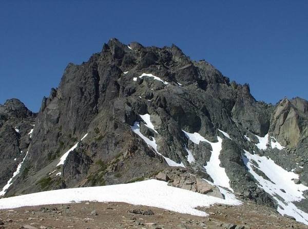
and could see the complex E face of Mt. Walkinshaw. At least I could
see it now! I ascended NW'ly up more boulders and then a bald scree
ridge popping out at the south end of Gray Wolf Ridge. To the SW was
the top 700' of my objective. [See Picture #1]
The smooth rolling ridge slammed to a stop in a series of 4-5
steepening ridge pinnacles that had to be traversed (all on the E
side) by hold-your-breath class-3 moves on rotten Olympic shale. Once
past these scary impediments, I was at the true base of Walkinshaw's
NE ridge. The rock changed character into a much more agreeable
solidity (pillow lava?). OK, now: which tower is the top and how am I
going to get there?
Staying mostly on the outside (E) of the ridge, I scrambled some
ledges and small gullies until I was forced ""inside"" (more towards
the center of the broken NE ridge). A sizeable gully opened up and I
gratefully groped my way up until - Bang!- the gully was obstructed
by a side-to-side headwall. It was just ten feet high, but it was
exposed on each side and too risky for this guy. Dropping maybe 50'
down the big gully, I tested routes to try to move even more ""inside""
and - Voila! - a way was found. Now up, up, up. Beneath an unclimb-
able plug I thought might be the top, I came to a level keyhole and
squished myself through onto what felt like ""the other side of the
mountain"". Now almost all the terrain swung downwards. It was
obvious that the plug was not the summit and that I'd have to angle
eastwards to locate the proper summit among two choices. I fumbled
over blocky ground and climbed the easternmost point first. Boy, it
sure looked as high as Choice #2, but I guess it wasn't. Scrambling
airily along a sharp blade of rock, I reached the top of Choice #2
and found a register pitoned into the summit. Nobody had signed in
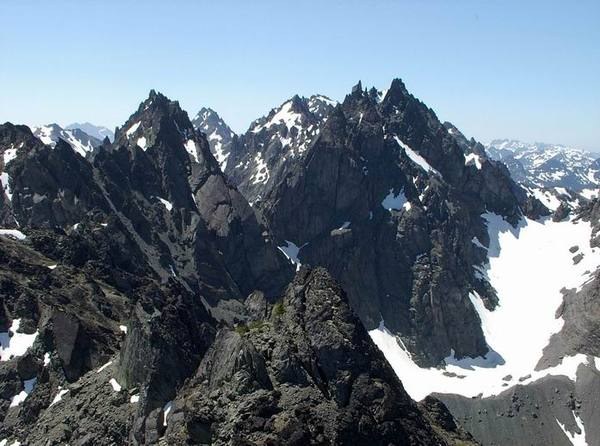
since Sept., 2006. One party in 2005. One party in 2004. Views were
wide, but most impressive was the further array of The Needles to
the south. [See Picture #2: Mt. Clark (L), Mt. Mystery, Mt.
Deception, and Mt. Johnson (R)] Just a stone's throw away was
Choice #1 seeming of equal height.
Carefully now, it was time to reverse the ascent. It actually was
a lot of fun. The scraggly forest was even more of a pain than on the
way up; but eventually the return to a buggy camp was done. A wash-up
was in order.
Day 3 saw me down the (did I say really pretty) Royal Basin Trail;
another coffee at Wild Birds; another crossing on the Kingston ferry.
Climb of Mt. Walkinshaw: priceless!
16.00 miles 6175' gain


Comments