
The Icicle Gorge Trail, one of the most popular trails in the Okanogan-Wenatchee National Forest, is a wonderful way to explore the natural beauty of the Icicle Creek Valley. The interpretive loop trail has a gentle grade and scenic views of Icicle Creek, Icicle Gorge, and the surrounding forest that are ideal for families, trail runners, beginner hikers, bird enthusiasts, and those looking to take a nice long walk on a well-defined path.
Start your hike from the parking lot, following the main trail to an information kiosk. Pick up a map of the trails and pause a moment to get your bearings. Read about the wildlife, conservation initiatives, and distinctive habitats in the surrounding area on signs pinned to the kiosk.
Continuing on the trail, come to a sign marked Icicle Gorge View River Loop. Turn left to start the four mile loop in a clockwise direction or turn right to do the loop in a counterclockwise direction. There is varied ecology to savor throughout the trail and you will encounter scenic views of the Icicle Creek Valley in either direction, but this description will take you on a clockwise loop.
Turning left, walk on the wide, well-traveled trail through the forest and come upon your first glimpse of Icicle Creek after about a quarter of a mile. A small bench on the left encourages a welcome rest, followed by the first of six interpretive signs you’ll encounter along the trail. Pause for a moment here to read about the aging lodgepole pine trees above you and the animal habitats they nurture.
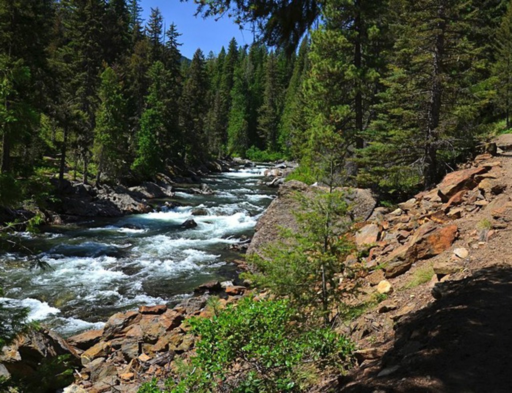
Continuing along the trail, look to your right at Icicle Creek and enjoy the varying shades of green and aqua colors shimmering below the surface. Arrive at the Icicle Creek Bridge and spot another interpretive sign about the animals and plants that make the unique habitat here their home.
As you cross the bridge, take a moment to enjoy the views of Icicle Gorge and the rushing, turbulent waters of Icicle Creek below you. Reaching the other side, you are now on the south side of Icicle Creek. The trail briefly continues along the creek before winding through a more heavily forested area. Pause at an overlook perched above the Creek, almost a mile into your hike, and continue through the forest to a cedar swamp.
Read about the cedar swamp on an interpretive sign as well as plants such as devil’s club: a shrub with large, maple-like leaves and small spines that are prickly to the touch. Keep your eyes peeled for scampering chipmunks and squirrels and listen for the tap-tap sound of pileated woodpeckers that call this area home.
After crossing a couple small wooden bridges, spot the small blue berries of Oregon grape lining the trail. Continue over bridges for Trout Creek and Jack Creek, and pause at two interpretive signs near Jack Creek to read about how plants, insects and fish thrive underwater and how birds, beetles and fungi are helping a nearby tree decompose.
Enjoy the peek-a-boo views of Icicle Creek beginning to re-emerge about two and a half miles into your hike, and cross a wide wooden bridge to reach a junction with Road 615. Bear right to stay on the Icicle Gorge Trail. As you continue on, look down at the views of Icicle Creek below you, being mindful of the steep drop-offs on the righthand side of the trail.
Continue on through a lovely section of tall conifers with views of nearby peaks in the Alpine Lakes Wilderness. Pass campsites for Rock Island Campground on your right, and emerge onto Forest Road 7600. Keep to the right on the road and cross the Rock Island Bridge, returning to the north side of Icicle Creek. Continue to a sign marked Icicle Gorge Trail River Loop, turning right to rejoin the Icicle Gorge Trail. There are picnic benches available here as well as a water fountain and vault toilets.
Enjoy plentiful views of Icicle Creek as you continue through this area. At a fork in the trail, head left to check out an interpretive sign on a plant called pine broomrape, or head right to walk a rockier trail closer to Icicle Creek. Either one will work: the trails rejoin in a short distance.
Cross a wooden bridge over Boggy Creek, and about 3.4 miles into your hike, notice a trail on your left that leads towards Forest Road 7600. This is an access point for the Icicle Gorge View Trail, a steeper, less traveled loop trail that climbs to higher-up views of the Icicle Creek Valley as well as Bootjack Mountain and Icicle Ridge.
To complete the Icicle Gorge Trail loop, continue straight on the trail past this junction. Pass by a couple exposed areas with benches that overlook Icicle Creek: good choices for a picnic lunch or a snack break. The parking lot will soon come into view on your left; bear right on the trail to finish the loop.
Extending your Hike: Head up the steeper Icicle Gorge View Trail (called simply “View Trail” on the map provided at the kiosk) to add roughly an extra 1.25 miles to your hike. At one point the View Trail splits and parts of the trail are overgrown with brush; be sure to read the entry for the Icicle Gorge View Trail on this site for the best route to take.
Icicle Gorge Nature Loop

-
 Length
- 4.2 miles, roundtrip
-
 Elevation Gain
- 150 feet
-
 Highest Point
- 2,800 feet
Parking Pass/Entry Fee
Northwest Forest Pass
The Icicle Gorge Trail, one of the most popular trails in the Okanogan-Wenatchee National Forest, is a wonderful way to explore the natural beauty of the Icicle Creek Valley. The interpretive loop trail has a gentle grade and scenic views of Icicle Creek, Icicle Gorge, and the surrounding forest that are ideal for families, trail runners, beginner hikers, bird enthusiasts, and those looking to take a nice long walk on a well-defined path.
Continue reading
Hiking Icicle Gorge Nature Loop
Wheelchair Accessibility
This trail is wide but borders Icicle Creek and at places there is a steep dropoff of between 3 to 8 feet to the creek below.

WTA worked here in 2024 and 2023!
Map & Directions
 Trailhead
Before You Go
Parking Pass/Entry Fee
Northwest Forest PassWTA Pro Tip: Save a copy of our directions before you leave! App-based driving directions aren't always accurate and data connections may be unreliable as you drive to the trailhead.
Getting There
From the 76 gas station off US Highway 2, on the western edge of Leavenworth, head south on Icicle Road (Forest Road 7600). The pavement ends after 12.4 miles, and the remaining 3 miles to the trailhead is mostly gravel, which can have a washboard surface at times.
Pass the Chatter Creek Guard Station at the 15 mile mark, and in about 0.4 miles turn left at the sign for the Icicle Gorge into the parking lot.
There are roughly 23 parking spaces in the lot and a vault toilet. A Northwest Forest Pass or Interagency Pass is required. A day pass is available for purchase for $5.00 from the wooden kiosk at the trailhead, payable by cash or check.