Trails for everyone, forever

Home Go Hiking Hiking Guide Baldy Mountain

Baldy Mountain

Central Washington > Yakima
46.7952, -120.4584 Map & Directions
Length
5.0 miles, roundtrip
Elevation Gain
1,972 feet
Highest Point
3,212 feet
Calculated Difficulty About Calculated Difficulty
Moderate/Hard
Baldy Mountain panorama. Photo by mytho-man. Full-size image
  • Dogs allowed on leash
  • Fall foliage
  • Mountain views
  • Ridges/passes
  • Rivers
  • Summits
  • Wildflowers/Meadows
  • Wildlife

Parking Pass/Entry Fee

None
Saved to My Backpack

This hike in the Yakima River Canyon is an excellent conditioning hike for anyone looking to train in the winter months. It reaches one of the highest points on the east side of the river in the Canyon. Continue reading

Rating
4.22 out of 5

(9 votes) Log in to rate

Hiking Baldy Mountain

Found on maps as the T.P. Jim Trail, the way up Baldy Mountain is open and exposed. T.P. Jim was a local tour guide and Central Washington University graduate who helped local youths avoid gangs trouble and become more involved in hiking and climbing. He has been honored with a trail and monument named after him. The monument can be found at the summit of Baldy.

There's a real danger of overheating on this trail in the summer months, so it may be best saved for an early spring or fall hike, perhaps even a winter conditioner.

From the road shoulder, head toward the gate, the only remaining portion of a cattle fence from long ago. There is a choice to be made now: steep or less steep. For a get-there-fast approach, continue straight through the gate. This is the T.P. Jim trail. It is extremely steep, but does provide a minimal amount of shade in before coming up onto a flank of Baldy into the sun. You will go through the bottom of a canyon draw, up to the point above you before continuing to the top of Baldy along the ridgeline.

The more moderate ascent is offered by the trail to your left just before you pass through the gate. Take a left before you get to the gate, stepping over old wire and barbed wire. After about 15-20 feet, you will find the more moderate route. This is a little more forgiving route as far as steepness goes, but it's very exposed. This trail sweeps around, adding a bit more length and distance but can be easier on the knees. The two routes converge about a mile up, and there are some very steep sections afterward, though not quite as steep as the start of the T.P. Jim Trail.

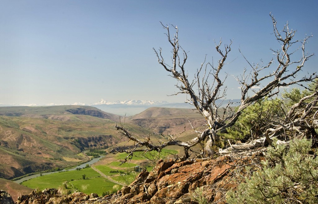
The way is straightforward. There are a few cairns along the way, and most of the route is along the ridgeline and can be windy at times. Along the way, enjoy wildflowers encouraging you with every step in the springtime. In autumn, the fall color in the Yakima valley can be stunning. And on clear days, the panorama of the Cascade crest is gorgeous. Wildlife include deer and big horned sheep. 

Toilet Information

  • No toilet at trailhead

More information about toilets

Baldy Mountain

Map & Directions

Trailhead
Co-ordinates: 46.7952, -120.4584 Open in Google Maps

Before You Go

See weather forecast

Parking Pass/Entry Fee

None

WTA Pro Tip: Save a copy of our directions before you leave! App-based driving directions aren't always accurate and data connections may be unreliable as you drive to the trailhead.

Getting There

From I-90 heading west, take exit 110 for I-82 and proceed south for 6 miles south to Thrall Road, exit 3. Turn west (right) for three quarters of a mile, and then turn left onto Canyon Road. Take Canyon Road 15 miles south to Big Pines Campground. Parking is available in this campground, but be sure to have a $5 BLM day-use pass. Find the trailhead across the road, 100 yards north, marked with a gate.

From the Yakima to the south, take I-82 north until exit 26 for the Yakima Firing Center/Training center. Turn left onto Firing Center Road, follow around the bend, drop down by Sundown M Ranch and thus begins the Yakima River Canyon or 821. Follow 821 for 10 miles to the Big Pine Campground on your left. There is parking just north of here on the west side of the road. 

More Hike Details

Trailhead

Central Washington > Yakima

Bureau of Land Management and Washington Department of Natural Resources

You can improve or add to this guidebook entry!

Baldy Mountain

155 Trip Reports

Hiked here recently?

Submit a trip report!
 
Trip Reports