Trails for everyone, forever

Home Go Hiking Hiking Guide Bayshore Preserve

Alert: On Oct. 1 the federal government began a partial shutdown that will impact National Parks, National Wildlife Refuges and U.S. Forest Service lands in Washington. Here's the latest information we have for hikers and campers


Bayshore Preserve

Olympic Peninsula > Olympia
47.2486, -123.0442 Map & Directions
Length
2.0 miles of trails
Elevation Gain
75 feet
Highest Point
40 feet

The preserve will be undergoing construction starting July 7 through Oct 2025. The Lookout Trail will be completely closed; the Main Loop and Johns Creek trails will temporarily be out-and-back trails. The main trailhead and restroom will also be closed. For more information about the closure, see: https://capitollandtrust.org/bayshore-updates/

Photo by D'Arcy Full-size image
  • Coast
  • Dogs allowed on leash
  • Good for kids
  • Wildlife

Parking Pass/Entry Fee

None
Saved to My Backpack

Bayshore Preserve is a 74-acre spread of land on the Bayshore Peninsula which pokes into Oakland Bay. A former golf course, WTA is working on improving the informal trails here so hikers can enjoy an area that is undergoing restoration efforts. Continue reading

Rating
2.50 out of 5

(2 votes) Log in to rate

Hiking Bayshore Preserve

Bayshore Preserve is a special place in the South Puget Sound. The 78-acre preserve is a former golf course which is being restored to nature by Capitol Land Trust. A short trail system here draws visitors through many interesting habitats including along a stream, an estuary, marine shoreline and Garry oak meadows. Visitors are asked to stay on trail, keep pets on leash and pack out anything you bring in with you. 

Open from dawn until dusk year round, the trail system at Bayshore totals roughly 1.5 miles. The Main Loop Trail is a former road, and as such is mostly flat and a mixture of dirt and gravel.

The Lookout Trail goes down a short hill and across a wide bridge crossing Johns Creek. From there, it heads up a short but steeper hill to a relatively flat trail.

The Shoreline Overlook Trail is a dirt trail that is relatively flat, but dips slightly towards the water.

Johns Creek Trail is a narrow dirt footpath and has several smaller hills, especially when it meets the Main Loop Trail on the south side of the trail. The Johns Creek Estuary Trail is a dirt path with a dip about halfway down. It can get muddy and wet along this trail, especially during high tide.

The lower portion of Johns Creek flows through Bayshore Preserve. It’s a great place to see chum salmon beginning in late October through mid-November. As you wander, note the young trees growing along the creek which were planted during restoration efforts. These trees provide shade to the creek, fish and wildlife habitat and act as erosion mitigators. 

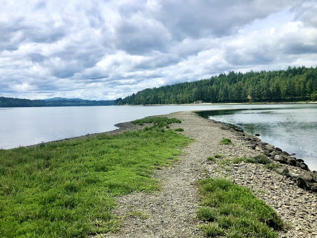
The trail follows Johns Creek to where it flows into Oakland Bay. This ecosystem is called an estuary, where fresh and saltwater mix. Estuaries provide great opportunities for wildlife viewing while simultaneously appreciating the larger landscape of Oakland Bay. The trail then follows the Oakland Bay shoreline.

As you continue to wander the trails, take note of the large Garry oak trees scattered throughout the preserve. The Garry oak is the only native oak species in western Washington. In the spring, lupine can be found flowering along portions of the trail. 

You can even help monitor the preserve by submitting photos from the photo points located around the preserve.

Note: The excavated areas between the Oakland Bay shoreline and the trail are called tidal basins. They were an important part of the restoration efforts at the preserve aimed at expanding the saltmarsh. Salt Marshes are an important habitat as many marine animals live here and since the restoration work in 2015, there has been an increase in this habitat.

WTA worked here in 2019!

Hike Description Written by
Multiple authors contributed to this report, WTA Community

Bayshore Preserve

Map & Directions

Trailhead
Co-ordinates: 47.2486, -123.0442 Open in Google Maps

Before You Go

The preserve will be undergoing construction starting July 7 through Oct 2025. The Lookout Trail will be completely closed; the Main Loop and Johns Creek trails will temporarily be out-and-back trails. The main trailhead and restroom will also be closed. For more information about the closure, see: https://capitollandtrust.org/bayshore-updates/

See weather forecast

Parking Pass/Entry Fee

None

WTA Pro Tip: Save a copy of our directions before you leave! App-based driving directions aren't always accurate and data connections may be unreliable as you drive to the trailhead.

Getting There

From Highway 101 west of the town of Shelton take the exit onto State Route 3 heading east. Follow SR 3 through Shelton and continue east on SR 3 along Oakland Bay. At 6.6 miles from Highway 101 Bayshore preserve will be on the right/southeast side of the road. Look for a Shell Gas Station immediately across the road on the north side. 

Because of the sensitive nature of Bayshore Preserve, there is no camping, foraging or hunting allowed here. 

More Hike Details

Trailhead

Olympic Peninsula > Olympia

Capitol Land Trust

You can improve or add to this guidebook entry!

Bayshore Preserve

5 Trip Reports

Hiked here recently?

Submit a trip report!
 
Trip Reports