

You can hike the Equestrian Trail all the way to the Hamilton Mountain Saddle for views of Mount Hood, Mount Adams, and Bonneville Dam far below. In spring, the Saddle has blooming wildflowers. including phlox, glacier lily, larkspur and Columbia lewisia.
From the Equestrian trailhead (840 feet), walk around the gate and head up the road. You will warm up quickly as the route climbs steadily up around switchbacks, crossing creeks and rounding slopes to traverse the south face of Hardy Ridge.
The trailside forest is a mix of Douglas-fir, western hemlock, big leaf and vine maple, and red alder with an understory of Oregon grape and sword fern. In spring, these forests have a wide variety of wildflowers, including western trillium, bleeding heart, fairy slipper orchids, red-flowering currant, sweet coltsfoot, toothwort, salmonberry, fairy bells and stream violets.
You may notice large, decaying stumps and logs and the occasional snag that are relics of the 1902 Yacolt Burn. A Civilian Conservation Corps camp at the park during the Great Depression of the 1930s employed young men to fell the trees killed by the fire. In those days, it was believed that snags attracted lightning and caused more fires.
In 1.2 miles, you will reach a four-way junction with the West Hardy and Lower Hardy trails (1,350 feet). Continue straight, watching for glimpses across the Hardy Creek valley to the west face of Hamilton Mountain. At 1.8 miles (1,550 feet), arrive at another four-way junction with East Hardy and Lower Hardy trails.
Straight ahead, the route descends to a crossing of Hardy Creek at 2.5 miles and the junction with the Hardy Creek Trail (1,440 feet). A picnic table here provides an inviting break before the final climb to the Hamilton Mountain Saddle.
Continue on, passing the junction with the Upper Hardy Trail at 2.6 miles. Beyond the junction, the route steepens in a long switchback, with bigger rocks underfoot so you might feel like a vehicle spinning its wheels to get traction.
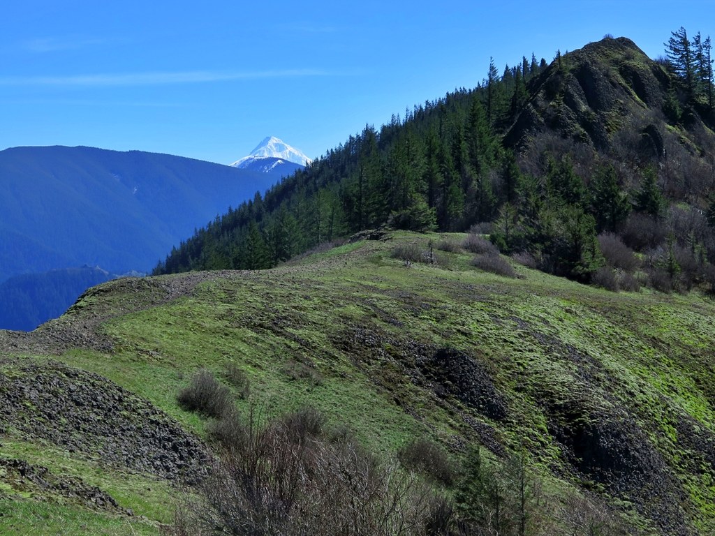
At the final switchback, pass the junction with Don’s Cutoff Trail on the left, an alternate return route (see separate hike description). Shortly after, you will reach the Hamilton Mountain Saddle at 2,300 feet. This open, flat, rocky area provides a perfect lunch spot or place to sit and contemplate the views.
Look across the Hamilton Creek valley to Aldrich Butte, Cedar Mountain, Table Mountain, South Birkenfeld Mountain and Birkenfeld Mountain. Bonneville Dam blocks the Columbia River far below, while Mount Hood peeks over the shoulder of Hamilton Mountain.
Turn around here, or pick up the Hamilton Mountain Trail going south along the ridge to tag the summit, adding 1.7 miles roundtrip and another 138 feet of elevation gain.
All trail junctions are signed and maps are posted on signboards.
 Trailhead


