Trails for everyone, forever

Home Go Hiking Hiking Guide Beaver Lake

Beaver Lake

North Cascades > Methow/Sawtooth
48.4681, -119.8836 Map & Directions
Length
2.0 miles, roundtrip
Elevation Gain
400 feet
Highest Point
5,500 feet
Calculated Difficulty About Calculated Difficulty
Easy

Beaver Lake is a nice short walk through starkly beautiful terrain still recovering from the Okanagon Complex fires in 2015. Continue reading

  • Wildflowers/Meadows
  • Dogs allowed on leash
  • Good for kids
  • Lakes
  • Established campsites

Parking Pass/Entry Fee

None
Rating
3.43 out of 5

(7 votes) Log in to rate

Hiking Beaver Lake

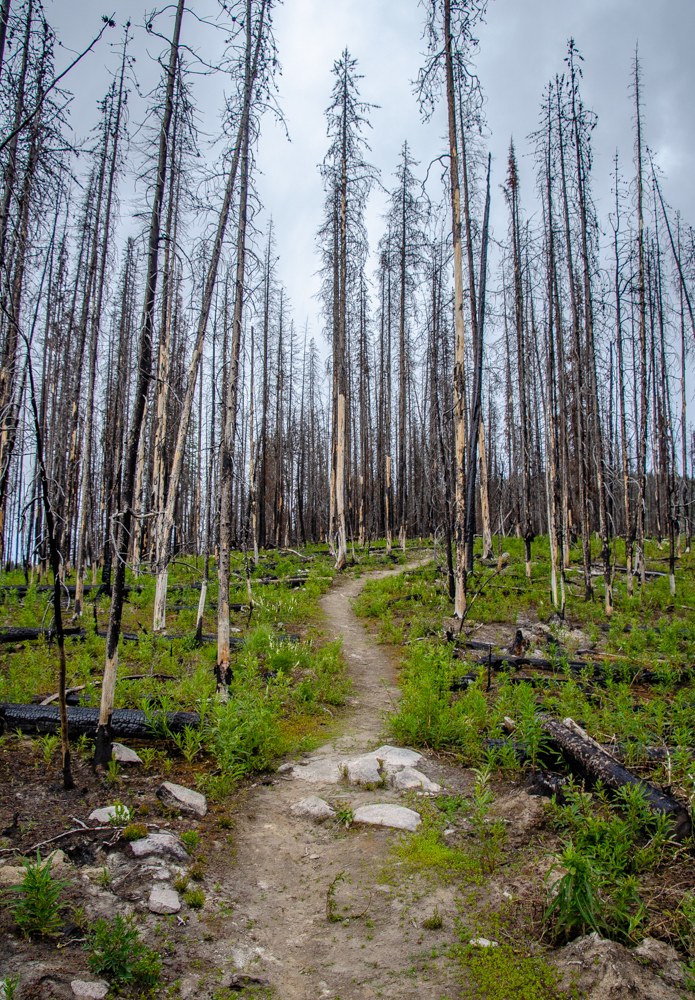
Beaver Lake is a forested lake north of Loup Loup Pass. It's not drop-dead gorgeous, but offers the hikers the rare chance to see terrain recovering from the devastating fires of the Okanagon Complex in 2015.

The trail is short, only two miles round trip with 400 feet of elevation gain. While it could be hiked quicker than the drive, a curious hiker will find much to delay arrival at the lake.

Virtually all the tall trees were killed in the fire, though many still stand. It's easy to think there's nothing left alive, but on the forest floor life is bursting forth. Beneath the dead trees, the ground is carpeted with wildflowers. Even when not in bloom, they are such a stark difference from the black and gray of the burn they seem more vibrant and colorful than they should be. 

The trail climbs in fits and starts with flats in between. Arriving at the lake, it splits. Heading counter-clockwise, you'll cross the outlet and circle the lake, but you'll never get too close to the water. Clockwise leads to a collection of big campsites with fire rings as well as access to the lake. There are trout in the lake, but also huge crayfish scuttling around the rocks. Presumably, there are beavers, too, but they keep to themselves.

When you return to the trailhead, be sure to go across the road and look at the devastation the fire wrought on the plateau. There's little growth between the trees, but if you search near the stumps and snags you'll find the next generation of seedlings coming up. Even if you don't go to the lake, this alone is worth a visit.

WTA worked here in 2022!

Hike Description Written by
John Soltys, WTA Correspondent

Beaver Lake

Map & Directions

Trailhead
Co-ordinates: 48.4681, -119.8836 Open in Google Maps

Before You Go

See weather forecast

Parking Pass/Entry Fee

None

WTA Pro Tip: Save a copy of our directions before you leave! App-based driving directions aren't always accurate and data connections may be unreliable as you drive to the trailhead.

Getting There

From Twisp travel State Route 20 east toward Okanogan. At the Loup Loup Summit take Forest Service Road 42 north. Turn left on Forest Service Road 4235. At about 1.5 miles, bear right on Forest Service Road 4235-100. The Beaver Lake Trailhead is about 3 miles ahead, on the left. 

Note: The roads are often blocked by snow November through March.

More Hike Details

Trailhead

North Cascades > Methow/Sawtooth

Beaver Lake (#356)

Okanogan-Wenatchee National Forest, Methow Valley Ranger District

Guidebooks & Maps

Day Hiking North Cascades (Romano - Mountaineers Books)

Buy the Green Trails Loup Loup No. 85 map

You can improve or add to this guidebook entry

Beaver Lake

13 Trip Reports

Hiked here recently?

Submit a trip report!
 
Trip Reports