
Beaver Lake Preserve is a 67 acre forest preserve located north of Beaver Lake Park in Sammamish. It's reached from W Beaver Lake Dr SE. There is no entry fee, and a sign at the trailhead indicates the park closes at dusk. The morning opening hour is not specified, so perhaps "dawn" is intended.
The Preserve offers a 1.2 mile loop trail that is nearly level, having an elevation change less than 50 feet. For a map, see the Trail Maps link at www.sammamishwalks.org. While Beaver Lake provides the southern boundary of the Beaver Lake Preserve, the loop trail is strictly a forest trail and does not include any of the lakeshore.
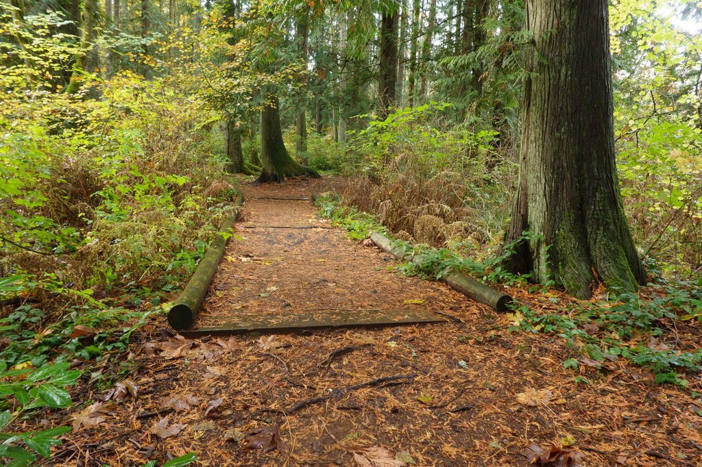
The loop trail passes through moist forest with a lot of very large trees, both deciduous and coniferous. A few well weathered stumps hint at the size of trees earlier loggers harvested here. The stumps seem no larger than the bases of the largest trees you see today, so perhaps some old growth does remain in the park.
While the loop trail has no lake of its own there are areas of standing water, and hanging moss and ferns are everywhere. You are likely to hear frogs, and perhaps the call of a raven or a woodpecker. A sign at the trailhead indicates there have been occasional black bear sightings, so stay alert. In season you may see a few wildflowers including trillium, Oregon grape, salmonberry, miner's lettuce and a lot of skunk cabbage.
Begin your hike by heading north from the parking area on the obvious trail. After 600 feet or so any equestrians or bikers are shunted off onto a separate trail that leads to Soaring Eagle Regional Park. The ongoing Beaver Lake Preserve trail veers sharply left, and is signed for foot traffic only. A few bikers seem to find this change confusing, and you might see occasional bike tracks in soft sections of the ongoing loop trail.
Part way around the loop, a connecting trail leads to the nearby Hazel Wolf Wetlands Preserve that has a loop of its own. So it's possible to include both loops in a single hike. Note, however, that dogs are not allowed on Ann's Walking Trail at the Hazel Wolf Wetlands, and the connecting trail will lead you directly onto that trail. So, if you plan to include the Hazel Wolf Wetlands in your hike today, please leave your dog at home.
As you hike the Beaver Lake Preserve loop trail you will find occasional signs that offer comments on various plants and animals that are seen in the park. About 2/3 of the way around the loop your trail will cross W Beaver Lake Drive SE then come to a signed, short side trail that leads about 100 yards to the Picnic Meadow. You can check it out if you like. The meadow is in a pleasant, grassy setting but as of spring 2015 it offered no picnic tables or any other facilities. From a slight rise at the far side of the meadow, a few hints of Beaver Lake can be seen through the trees. This is the only point on your hike where you will be able to see any of the lake.
Return to the loop trail and continue on, now heading back north. Soon, the trail re-crosses W Beaver Lake Drive SE then returns to the trailhead parking area to complete your hike.
Beaver Lake Preserve

-
 Length
- 1.2 miles, roundtrip
-
 Elevation Gain
- 50 feet
-
 Highest Point
- 460 feet
Parking Pass/Entry Fee
None
Hike a 1.2 mile loop trail through this forest preserve. Appreciate the exceptionally tall trees, both deciduous and coniferous. Pass some swampy areas with standing water, and note the exuberant growth of ferns and hanging moss.
Continue reading
Hiking Beaver Lake Preserve

WTA worked here in 2018, 2017, 2016, 2007 and 2006!
Map & Directions
 Trailhead
Before You Go
Parking Pass/Entry Fee
NoneWTA Pro Tip: Save a copy of our directions before you leave! App-based driving directions aren't always accurate and data connections may be unreliable as you drive to the trailhead.
Getting There
From I-90 in Issaquah, take Exit 17 (Front Street) and head north. Front Street soon becomes Lake Sammamish Pkwy. About 2.2 miles from I-90, turn right at a roundabout onto SE 43rd Wy. This street winds up the hill, turns north and becomes 228th Ave SE. About 2.4 miles from the roundabout, turn right on SE 24th St. In another 1.4 miles, the ongoing street becomes a "No Outlet" street, and you'll need to bear right. The street soon becomes W Beaver Lake Dr SE. After 1.1 miles, be alert for a left turn into the small parking area at the Beaver Lake Preserve Trailhead. There is room for about 10 cars in the lot. Additional parking for 4 or 5 cars is available across W Beaver Lake Dr SE on the wide shoulder. A portable toilet is available at the trailhead. There is no regular source of water.
Beaver Lake Preserve also can be reached via the connecting trail from the Hazel Wolf Wetlands Preserve.
Take Transit:
Metro bus routes in Sammamish currently (2015) do not run as far east as the Beaver Lake Preserve. The nearest routes run along 228th Ave SE, an imposing 2.5 miles west of the trailhead. Check metro.kingcounty.gov for schedules.


