
In the mid-1800s, this pocket in the foothills about 25 miles east of Bellingham was just a big, forested canyon with a creek snaking through the bottom. But some 150 years ago, an earthquake collapsed much of the canyon's forested west wall, which slid into the creek, creating a natural dam in the process. Thus Canyon Lake was born. Today, evidence of the slide can be seen in the hundreds of cedar snags that poke up through the lake's surface.
The Canyon Lake Community Forest was developed in 1993 after the discovery of an old growth forest. Now it's a refuge for hikers and bikers seeking a retreat from the city. Visitors may also see owls, bears, cougars, even pika.
The highlight of the 2,300 acre Whatcom County Park is about three miles up the hillside. There, a 1.2 miles needle-strewn dirt trail wends its way through a 700-acre stand of old growth forest. Here hikers will find Alaska yellow cedars, hemlocks and Pacific silver firs more than 800 years old. Some of the trees may be more than 1,000 years old. It's one of the oldest forest stands known in the Pacific Northwest.
Because of the relatively high elevation of the forest -- about 3800 feet -- the wonderfully gnarled trees, despite their age, are not the giants one might expect. Still, they're stately, grand, and super tenacious -- they've had dibs on this place for a thousand years.
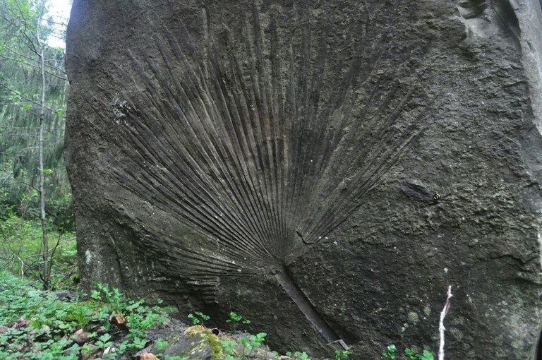
In either case, be warned -- the access road to Canyon Lake Community Forest was washed out in several places by a storm in January 2009. The road is closed at the gate, tacking on 5.7 miles to access any hike in the area. But the opportunities to see the flora and fauna - even a fossilized palm frond on the Lake Loop Trail - make this area worth the effort it takes to get there.
Canyon Lake Community Forest

-
 Length
- 7.5 miles, roundtrip
-
 Elevation Gain
- 2,400 feet
Parking Pass/Entry Fee
None
This community forest is managed as a nature reserve, where hikers will find a wide ranging variety of wildlife, and a retreat from the noise and bustle of city life.
Continue reading
Hiking Canyon Lake Community Forest

WTA worked here in 2022!
Canyon Lake Community Forest
Map & Directions
 Trailhead
Before You Go
Parking Pass/Entry Fee
NoneWTA Pro Tip: Save a copy of our directions before you leave! App-based driving directions aren't always accurate and data connections may be unreliable as you drive to the trailhead.


