
The 44-mile loop through Cathedral Pass offers some of the best scenery that the Pasayten’s breathtaking Boundary Trail has to offer. You’ll start and end at the Thirtymile trailhead on the Chewuch River out of Winthrop.
It’s a gentle and stark beginning to a long trek. Walk for many easy miles along the Chewuch River, staying on The Chewuch Trail (510) as it heads north for 6.5 miles through a burned forest that is slowly recovering from fires in 2001, 2003, and 2006. After an additional 2 miles it turns west and continues along the river another 7 miles, where it crosses Cathedral Creek, one of the major feeder creeks to the Chewuch River. At the crossing, you’ll begin to climb for two miles, paralleling Remmel Creek and arriving at a high point of 6600 feet—17.5 miles from the trailhead.
Eventually you will pass the now abandoned old Chewuch River trail. The Forest Service has rerouted the Chewuch River trail (#510). Continue on the newer Chewuch River trail.
Next you will reach a junction with the Lesamiz trail (#565). You can either continue on the Chewuch River trail to Remmel Lake or take the Lesamiz trail to the upper Cathedral Lakes basin and Ampitheatre Mountain. Take the Lesamiz trail if you are doing the Cathedral Pass Loop.
In a mile or two, you'll reach another junction with the Remmel Lake cutoff trail. If you want to head to Remmel Lake for a quick swim and didn't take the Chewuch River trail, take the cutoff trail 1/4 mile to the lake. If your destination is Cathedral Lakes, continue on the Lesamiz trail.
(Note: As of August 2016, the Green Trails map for this area does show the Chewuch River trail reroute on the Lesamiz trail.)
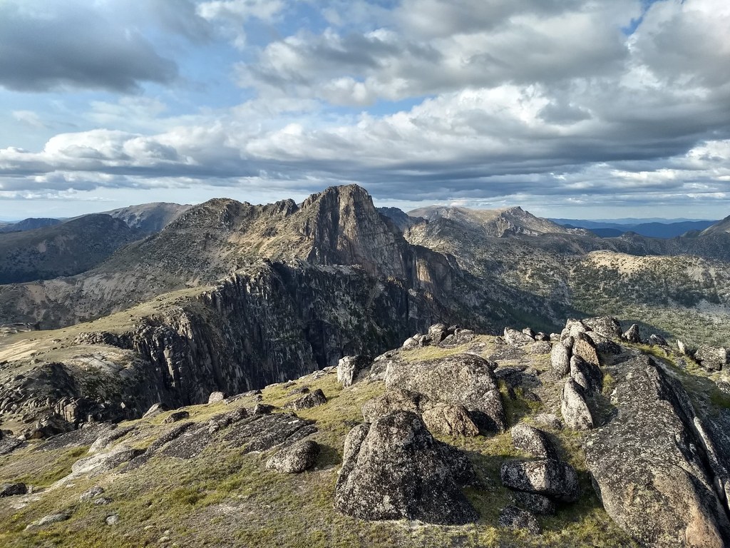
As you continue higher on the Lesamiz trail, views of Remmel Mountain to the south and Cathedral Peak and Amphitheatre Mountain to the north make excellent alpenglow viewing and provide beautiful photo opportunities.
Eventually you'll reach another junction. You can stay to the right and head straight to Upper Cathedral Lake and Ampitheatre Mountain or you can head in a westerly direction to connect with the Boundary trail (#533) for a more meandering route. Either way can get you to Upper Cathedral Lake, just make sure if you take the Boundary trail, you head east on the trail toward the Upper Cathedral and Ampitheatre.
In no time you will be traversing above Upper Cathedral Lake, which is situation below Ampitheatre Mountain. Larch groves hide the lake, however a number of social paths lead down to its shoreline where you can find a handful of campsites.
Switchback up to the left towards Upper Cathedral Lake and stunning Cathedral Pass. If you can time it right, try camping on this section of the trail, as the evening and morning light on the rocks here is truly stunning.
To continue your loop, the Boundary trail heading east continues on a high traverse through open terrain in this area, passing through aptly named Apex Pass, at 7800 feet, the highest point of this hike. About a mile from Apex Pass, arrive at a junction with the Tungsten trail (534). Note that the Tungsten trail junction lies below the Tungsten Mine buildings and mine shaft structure. It can be a little tough to find as there are a number of social trails in the area, however if you go downhill from the mine buildings and mine shaft, you will find it. Turn right onto this trail and continue on a gentle downhill grade for six miles to reconnect with the Chewuch Trail. This marks the end of the lollipop portion of your loop—you’ll retrace your steps along the Chewuch River for 8.5 miles back to your car.
Cathedral Pass Loop

-
 Length
- 44.7 miles, roundtrip
-
 Elevation Gain
- 4,000 feet
-
 Highest Point
- 7,800 feet
Parking Pass/Entry Fee
Northwest Forest Pass
Hike through some of the Boundary Trail’s best scenery on the 44-mile lollipop loop along the Chewuch River and through majestic Cathedral Pass.
Continue reading
Hiking Cathedral Pass Loop

WTA worked here in 2021 and 2019!
Cathedral Pass Loop
Map & Directions
 Trailhead
Before You Go
Parking Pass/Entry Fee
Northwest Forest PassWTA Pro Tip: Save a copy of our directions before you leave! App-based driving directions aren't always accurate and data connections may be unreliable as you drive to the trailhead.


