

This year-round hike offers great views of the Columbia River Gorge along with enchanting stands of oak, cascading waterfalls, dramatic basalt outcroppings, and profuse wildflowers in the spring. Often sunny here while raining in Vancouver, it is a great place to hike while waiting for snow to melt at higher elevations.
This loop hike begins with a walk along an old highway to the start of the Labyrinth Trail. This is where the fun begins. For the next two miles, the trail weaves up though surprising diverse landscape that includes grassy plateaus, a creek with cascades and a waterfall, rocky protrusions, talus slopes, and dramatic views of the Gorge.
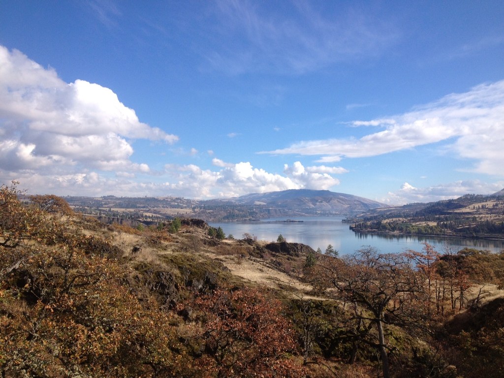
At the top of the loop, the trail breaks out onto a grassy slope with unhindered views of the Columbia River. In the spring there is a steady progression of wildflowers, including grass widow, prairie stars, yellow bells, camas, and balsam root.
Park at the Coyote Wall Trailhead and walk east on the old Highway 8 roadbed at the base of the namesake "wall". After 0.6 miles, you will come to an obvious trail heading uphill to the left. This will be where you rejoin the old highway near the end of your hike. Stay on the roadway. In another 0.3 mile, just before the road goes through a rocky notch, you will come to the Labyrinth Trail (CO7) junction on the left side of road.
Take the Labyrinth Trail (CO7) up the hill. Shortly after beginning, you will come to a junction where you need to stay to the right as the trail climbs through a rocky chute. The trail gets quite interesting here as it goes around basalt outcroppings, hop-scotches through oak groves, and nears Labyrinth Creek. In about 0.3 miles from the trailhead, the trail passes a small cave on the left then comes to Labyrinth Falls where the creek tumbles through a series of cascades. There is a short steep section after the falls, but then the trail levels out with views of the Columbia River.
About 0.5 miles beyond the falls, you will see user trails to the right that lead to a scenic outlook. This makes an excellent spot for a break, especially on a sunny day. After visiting the viewpoint, continue up the Labyrinth Trail 0.2 miles to a trail junction near abandoned power lines and a fence. A user-trail to the left used to ascend the valley, but was decommissioned as per the Forest Service recreation plan. Stay right and continue climbing. In another 0.3 mile, you will come to the junction with the Upper Labyrinth Trail (CO8).
Turn left at the junction to join the Upper Labyrinth Trail. In 0.1 mile, the trail breaks out onto a grassy plateau with outstanding views of the Columbia River to the south and Catherine Creek to the east. This is another perfect spot for a break. After enjoying the panoramic view, return to the Upper Labyrinth Trail and go another 0.3 miles to the junction with the Atwood Road Trail.
When you come to the Atwood Road Trail, turn left and follow the abandoned road 0.6 miles as it goes back into a grove of trees, drops a bit to cross a stream, then goes uphill to a three-way junction. Take the track on the far left to an open grassy area where the hike joins the “Old Jeep Road” (CO4).
From here on, the hike descends a grassy incline, providing sustained views of the Columbia River and the basalt cliffs of the Gorge. The wide-open vista is eye-popping beautiful, especially in the spring when the wild flowers are blooming.
Two miles down the old jeep road, you will pass a trail going uphill to the right and then come to a barb-wire fence. Just before going through a gap in the fence, it is worth taking the side trail to the right to peer over the top of Coyote Wall’s 300 foot rocky cliff.
After enjoying the view, return to the old road and go through the fence. Follow the road as it zigzags down the slope, giving you different photo opportunities at each turn. Just after the fence, you will come to the Little Moab Trail (CO3). Turn left to stay on the jeep road. Then, after another 0.2 miles you will come to the Maui Falls Trail (CO5). Turn right and continue 1.6 miles downhill to the old highway.
Near the bottom of the old jeep road, you will encounter a maze of trails with several options for returning to the old highway. Keep on an established trail and watch out for mountain bikers. After reaching the old highway, turn right to return to your car.
CAUTION
There is poison oak along the Labyrinth trail. Know what it looks like, dress appropriately, and watch what you touch. Don’t let this deter you from taking this wonderful hike, however.
WTA Pro Tip: A perfect way to end your Coyote Wall experience is to stop in Stevenson Washington for a snack or dinner at the Walking Man Brewery or the Big River Grill. The Walking Man Brewery serves a wide variety of their own brews along with sandwiches and gourmet pizzas (these are especially good). Plus, the outdoor seating area allows you to continue your commune with nature. This is odd advice, but be sure to check out the décor of the restrooms. If you’d like a more upscale dining experience, go to the Big River Grill which features Northwest Cuisine using fresh local ingredients. With its license plate collection and Columbia River sturgeon mermaid, the food is Portland-good and the atmosphere roadhouse quirky.

 Trailhead


