
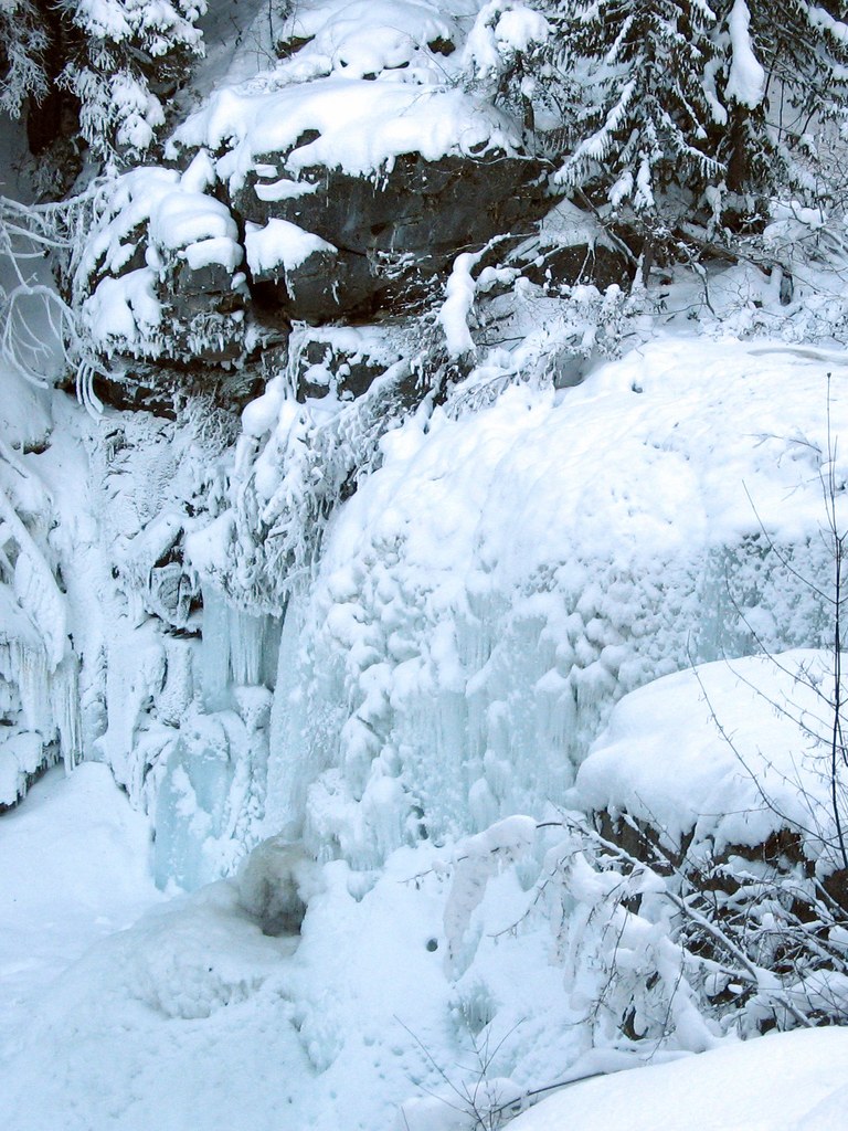

The more strenuous winter version of this easy summer hike leads to the overlook of Cedar Falls. In winter, the falls are a snow-topped mound of ice with a flowing creek base.
In mid-winter, the trip starts at the end of plowing for State Route 20, a joint parking area for skiers and snowmobiles at 2210 feet of elevation. The first 2.1 miles are westbound on State Route 20 with the snowmobiles. Be aware that weekends bring many snowmobiles onto this road, some moving quite fast.
While trudging up the road, take in the few peek-a-boo views of Gardner Mountain and Silver Star Mountain. At 1.5 miles, the road crosses Early Winters Creek, providing a look at the snow-covered creek. At 2.1 miles (2670 feet), on the left is USFS Road 5310-200, marked Trailhead. This is your stop.
Turn up the road, leaving most, but not all, of the snowmobiles behind. Follow the road as it climbs through the forest, reaching the summer trailhead for Cedar Creek 3 miles from the end of plowing at 3040 feet of elevation. Typically, the tracks of many animals, like deer, coyote, weasel, snowshoe hare and others will be evident along and crossing the road in this area.
The summer trailhead facilities are usually unlocked, and the trail register is available. The trail to the falls starts to the left of the trailhead sign. However ,the route is not marked with signs or blazes, so understand your route and have a map -- simply following in someone's footsteps does not guarantee you'll arrive safely at your destination. Remember that it is not unusual to be breaking trail, knee deep in snow for the next 1.8 miles, which can be quite strenuous.
From the trailhead sign, the trail initially goes east for about 60 yards and then turns south onto a climbing traverse, crossing a small creek bed at 3.3 miles. At 3.4 miles the trail is on a nearly level bench suitable for winter camping.
After the level bench, the trail gradually climbs on a sidehill, crossing many dry creeks. Depending upon snow condition, the tree wells can be fairly deep and/or icy, while the open areas can be deep snow.
Cedar Creek is well below the trail, and barely heard, until about 4 miles. At 4.6 miles, the trail crosses a couple of steep slopes, one with a 100ft run-out down to the creek.
The unmarked falls are reached at 4.8 miles and 3570 feet of elevation, evidenced by a shallow bench to the left (east) of the trail, also a viable campsite.
The falls are only visible from the edge of the bench area. As this area has numerous rocky cliffs, care should be taken approaching the edges to get a view of the falls, due to overhanging snow buildup. In November, the falls have an icy fringe and by mid January, the fall are obscured by the buildup of ice clinging everything in the falls basin.
Note: The snow and road conditions cause significant variability in the round trip distance & elevation gain, ranging from 3.6 miles & 530 feet elevation gain to 9.6 miles & 1360 feet elevation gain. The shortest is in November, while the summer trailhead is accessible and the trail is snow covered. The longest is in January-March when State Route 20 is blocked by snow at milepost 178. In December and April, when a small turnout is plowed at the junction with USFS 5310-200, the trip is 5.4 miles & 900 feet of elevation.
 Trailhead


