Trails for everyone, forever

Home Go Hiking Hiking Guide Cispus Braille Trail

Alert: On Oct. 1 the federal government began a partial shutdown that will impact National Parks, National Wildlife Refuges and U.S. Forest Service lands in Washington. Here's the latest information we have for hikers and campers


Cispus Braille Trail

South Cascades > Dark Divide
46.4387, -121.8526 Map & Directions
Length
0.6 miles, roundtrip
Elevation Gain
80 feet
Highest Point
1,388 feet
Calculated Difficulty About Calculated Difficulty
Easy
The Cipus Braille Trail and the guidance line pulling hikers along this peaceful forest trail. Photo by Shannon Leader. Full-size image
  • Dogs allowed on leash
  • Good for kids
  • Old growth
  • Rivers
  • Wildlife

Parking Pass/Entry Fee

None
Saved to My Backpack

The Trail for The Blind is a level grade trail adjacent to the Cispus Learning Center in foothills of the Cowlitz Valley. It is a part of the Covel Creek Trail System and is designed to allow easier access and highlight natural features in the forest for those who are visually challenged. This is also a great hike smaller children and those with less mobility. Continue reading

Rating
2.75 out of 5

(4 votes) Log in to rate

Hiking Cispus Braille Trail

This trail is a part of the Covel Creek Trail System across from the Cispus Environmental Learning Center. Built in June of 1988, it was upgraded by a local Boy Scout troop in 2002. It is a level grade trail less than three-quarters of a mile long that starts across the street from the learning center and makes a loop that briefly joins the Covel Creek Trail where it runs next to Covel Creek. 

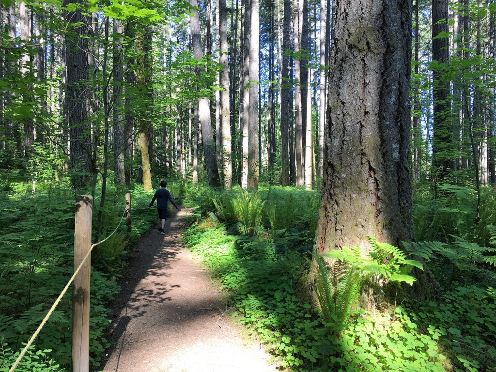
It is wide in most places and has a white guidance line running through round wooden posts so that those who are visually challenged can make their way along the path. It is designed to both keep you on the trail and highlight natural features in the forest.

You start out on a generous path from the road and are greeted by a trailhead sign from the local Lions and Lioness clubs that donated for the trail. The sign is in English and Braille (the trail is commonly referred to as the “Braille Trail”). 

From here, the trail begins to the right (the left takes you to a trailer park) and into a lightly treed forest mixed with firs, cedars, and dogwood that allows sunlight to brighten your walk. Although the trail is wide and flat and signed as “Easy”, there are a few random roots and cut stumps to watch out for that keep this trail from being officially barrier-free. The trail is lined with verdant understory: sword ferns, wood sorrel, vanilla leaf and thimbleberry.

About a quarter mile in you come to the beginning of the loop and you can go either left or right. The right will take you along the trail past an old-growth tree that you can walk around on the guideline and run your hand along the roughness of its gnarled bark. This is also the junction where the trail joins the Covel Creek Trail and continues toward a sitting area next to the creek. You can either sit on the sturdy wooden benches and listen to the gurgling brook as it meanders by or venture down to the water.

However, the bank drops down a few feet and there is no guideline once you step off the trail proper. If you find yourself creekside, there is a small platform at the water’s edge made from railroad ties that define a small shelf for exploring the creek bed and to feel the water flow by.

From here, the trail continues with the guideline a few hundred yards and branches off to the left leaving the Covel Creek Trail and completing the loop. There is a brief section where the guideline takes you off the actual trail to walk briefly along a downed nurse log.

You can explore the tiny soft mosses and dainty ferns that have found a home on its decaying bark.  You may even be able to reach your hand up and feel the new life of sapling emerging from the top of the log.

You will soon be back to where the loop ends and the trail takes you back the left towards the trailhead in less than three-quarters of mile. For those who are not visually challenged, it is an interesting exercise to walk the trail with your eyes closed. This gives you the opportunity to experience the outdoors in a whole new way. Listen to the birds chirp and the wind through the leaves. 

Toilet Information

  • No toilet at trailhead

More information about toilets

Wheelchair Accessibility

This trail is largely flat, but roots poking through the ground make it not entirely barrier-free. The tread narrows the further you get from the trailhead, and at it's narrowest is about 2.5 feet wide. It is possible to turn around at the nurse log detour though, about 0.25 miles in if you take the left branch of the loop when you get the fork, and most of the worst roots are past the nurse log.

Hike Description Written by
Shannon Leader, WTA Correspondent

Cispus Braille Trail

Map & Directions

Trailhead
Co-ordinates: 46.4387, -121.8526 Open in Google Maps

Before You Go

See weather forecast

Parking Pass/Entry Fee

None

WTA Pro Tip: Save a copy of our directions before you leave! App-based driving directions aren't always accurate and data connections may be unreliable as you drive to the trailhead.

Getting There

Take the exit off I-5 for Highway 12 signed for Mount St. Helens and Mount Rainier (White Pass).  Drive about 47 miles to the small town of Randle and turn right on Highway 131 signed for Mount St. Helens. 

In one mile the road splits. Keep left on FR 23 nd follow the signs for the Cispus Learning Center. In 8 more miles you will turn right onto Cispus Road (FR 29) and cross over the Cispus River. You'll soon turn right again to stay on Cispus Road (FR 28) and cross over Yellowjacket Creek. 

Turning right once more on FR 76 (still Cispus Road), you will see the sign for the learning center on your right in about 1/4 mile. There is a small area to park in at the End School Zone sign, or you can park along the entrance to the school or road.

More Hike Details

Trailhead

South Cascades > Dark Divide

Trail for The Blind (#228)

Gifford Pinchot National Forest, Cowlitz Valley Ranger District

Guidebooks & Maps

Day Hiking: South Cascades (Nelson - Mountaineers Books)

Green Trails No. 333 McCoy Peak

You can improve or add to this guidebook entry!

Cispus Braille Trail

9 Trip Reports

Hiked here recently?

Submit a trip report!
 
Trip Reports