
Start at 200 feet above sea level and climb to a lofty, scenic peak of 4492 feet on a long, switchbacking trail through stunning old-growth forest. WTA did more than 20 days of work on this trail in 2011, working hard with the Forest Service to reopen a trail that was nearly lost to a huge storm in 2007.
The trail starts out at a pretty steep grade with lots of loose rock -- you'll want gaiters and sturdy boots for this hike. After about half a mile, the trail surface smooths out (but the grade stays steep) as you continue to switchback uphill.
WTA crews, along with other trail maintenance crews focused their repairs near the mile to 1.5 mile mark. Past this point, where it can be difficult to get day work parties, hikers may encounter blowdowns or brush, and the tread may be loose in some of those spots.
The first five miles of the Colonel Bob trail is steep, and largely view-free, but the fun really starts after the junction with the Petes Creek trail, an alternate route to the summit. Shortly past this junction, the trail incline increases significantly, but luckily, there are wildflowers filling these meadows in the spring. Look for coltsfoot, trillium, and yellow violets, as well as oxalis, a vivid green groundcover, most evident near the bottom of the trail. Shortly past the meadow, the trail levels out a little until reaching a creek.
This is the last water source, and given the incline, it's wise to fill up here, because the last mile of the trail is much more technical. If that's not your bag, there's a nice cirque near the stream that makes a good turnaround spot. If you want to press on, do so with full bottles. Covering perhaps 1000 feet in one mile, this stretch is a leg burner at its most generous description. Many people use this trail to train for climbing Mount Rainier.
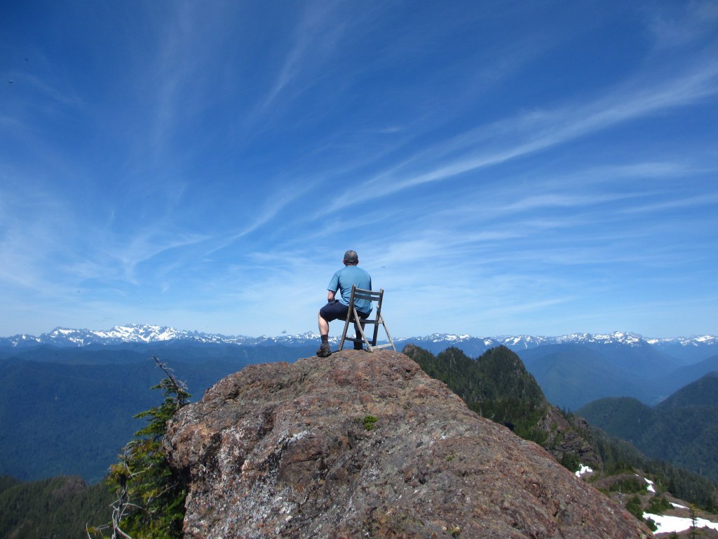
Shortly before reaching the summit, you may glimpse a sign on a that reads simply, '7'. It may be an old mile marker, since it's seven miles the to summit via the Colonel Bob trail. But the last push and the relentless incline rewards you with an awesome 360-degree view down to Lake Quinault and the Quinault River, Mount Olympus, Mount Rainier, even the Pacific Ocean to the west.
Colonel Bob Trail - Colonel Bob Peak

-
 Length
- 14.0 miles, roundtrip
-
 Elevation Gain
- 4,292 feet
-
 Highest Point
- 4,492 feet
Start at 200 feet above sea level and climb to a lofty, scenic peak of 4492 feet on a long, switchbacking trail through stunning old growth forest. WTA has done a lot of work on this trail to improve it after a huge storm in 2007.
Continue reading
Hiking Colonel Bob Trail - Colonel Bob Peak

WTA worked here in 2025, 2022, 2021, 2017 and 2016!
Colonel Bob Trail - Colonel Bob Peak
Map & Directions
 Trailhead
Before You Go
Parking Pass/Entry Fee
NoneWTA Pro Tip: Save a copy of our directions before you leave! App-based driving directions aren't always accurate and data connections may be unreliable as you drive to the trailhead.


