Trails for everyone, forever

Home Go Hiking Hiking Guide Fort Stevens Clatsop Spit

Fort Stevens Clatsop Spit

Southwest Washington > Columbia River Gorge - OR
46.1942, -123.9740 Map & Directions
Length
15.0 miles of trails
Elevation Gain
93 feet
Highest Point
100 feet
The wreck of the Peter Iredale is a major attraction to the spit. Photo by Alpine Wanderer Full-size image
  • Coast
  • Dogs allowed on leash
  • Established campsites
  • Good for kids
  • Lakes
  • Wildlife

Parking Pass/Entry Fee

Oregon State Parks Day-Use
Saved to My Backpack

Visit one of the nation's largest public campgrounds and marvel at the geographic phenomenon that is the Clatsop Spit at Fort Stevens State Park. Learn about local history and embrace the rugged Oregon coast where the Columbia meets the Pacific. Continue reading

Rating
0.00 out of 5

(0 votes) Log in to rate

Hiking Fort Stevens Clatsop Spit

The Clatsop Spit is an enormous sand spit at the mouth of the Columbia River, extending from Oregon into the Pacific Ocean. It was formed by sediment, carried by the Columbia, over thousands of years. The result is the peninsula where Fort Stevens State Park now sits. This sand bar extends under water into the Pacific, contributing to the Columbia Bar: a system of shoals and sandbars that make navigating the channel a treacherous obstacle for ships.

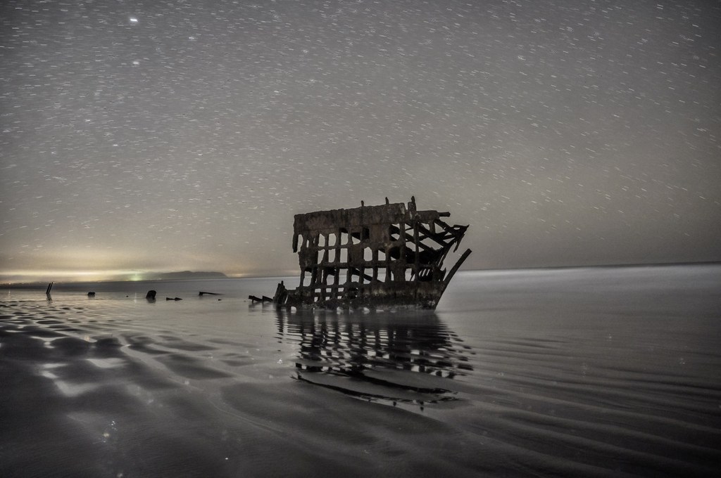
Sometimes referred to as the "Graveyard of the Pacific", the westward side of the spit is notorious for its dangerous waters. It's believed that up to 2,000 ships have wrecked there since the 1800s. The Wreck of the Peter Iredale is a short hike and perhaps the most famous of these shipwrecks, but whales are known to beach themselves along the spit occasionally as well.

You may want to review a map of the area before you visit. Or make a weekend of it and reserve a campsite!

There are a few trails offering access to the best of what the spit has to offer:

  • The Peter Iredale Shipwreck is a quarter mile (one way) walk from the trailhead of the same name.
  • Lots A and B offer trails to explore dunes on the westward face of the peninsula
  • Lot C offers a rugged walk along the shore, beneath the (closed) South Jetty Observation Tower. This is also the northern terminus for the Oregon Coast Trail, so keep an eye out for backpackers and thru hikers!
  • Lot D brings hikers to the interior (eastward facing) section of the peninsula, offering slower waters, birding and even a wildlife viewing bunker from the beach.

Note: much of the northern end of the spit will continue to be closed for several years as the park works to provide more infrastructure to the parking lots, jetty and trail system.

Toilet Information

  • Toilet at trailhead

More information about toilets

Wheelchair Accessibility

There are paved trails and bike paths throughout the park but they might not be accessible to all wheelchair users.

Hike Description Written by
Joe Gonzalez, WTA Staff

Fort Stevens Clatsop Spit

Map & Directions

Trailhead
Co-ordinates: 46.1942, -123.9740 Open in Google Maps

Before You Go

See weather forecast

Parking Pass/Entry Fee

Oregon State Parks Day-Use

WTA Pro Tip: Save a copy of our directions before you leave! App-based driving directions aren't always accurate and data connections may be unreliable as you drive to the trailhead.

Getting There

From heading northbound on Highway 101, turn northwest onto OR-104 N for 0.3 miles before turning left onto Columbia Beach Road, which will soon become Ridge Road. Continue for about four miles, then turn left on Peter Iredale Road to enter the state park. Once in the park, stop at the visitor center, turn into a campground, or continue straight for more trailheads. Turn right onto Burma Road for access to further lots in the northwest portion of the park.

If heading westbound on Highway 30, continue through Astoria to where Highway 30 becomes Highway 101. Head southwest over the Youngs River along the New Youngs Bay Bridge and turn west onto East Harbor Drive. Continue for 1.3 miles, then turn south onto North Main Avenue. Follow North Main Avenue for half a mile before turning west onto Southwest 9th Street. Finally, turn right onto Ridge Road and follow it a few miles before turning westward onto Peter Iredale Road and into the park.

More Hike Details

Trailhead

Southwest Washington > Columbia River Gorge - OR

Oregon State Parks

You can improve or add to this guidebook entry!

Fort Stevens Clatsop Spit

3 Trip Reports

Hiked here recently?

Submit a trip report!
 
Loading trip reports...
Trip Reports