
There are two ways to attain Fourth of July Pass - from Thunder Creek or from Panther Creek. Both offer wonderful opportunities to travel along burbling, blue-green creeks, but access via Thunder Creek is truly stunning. Make it an out-and-back or stash a second car for a traverse.
The trail starts out easy as it gently wanders alongside turbulent Thunder Creek leaving Colonial Creek and heading upstream for two miles. One-third of a mile past the bridge, reach the trail to Fourth of July Pass on the left.
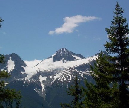
Take this trail, which marks the beginning of a steep ascent, climbing 2000 feet in just 2.5 miles to Fourth of July Camp at 3400 feet. You'll appreciate the cool forest cover as you climb, and when the forest gives way, it's to spectacular views of Colonial Peak, Snowfield Peak and Neve Glacier as you near the camp. If you're backpacking, this is the place to stay - some of the camp spots have fabulous views.
From the camp, it is less than a mile to the pass at approximately 3600 feet. The pass is 5.3 miles from the trailhead but is indistinct, unsigned, forested, and has no views. On the way, you'll pass a nice overlook of the Panther Potholes just short of the pass but unless you are continuing down to Highway 20 via the Panther Creek trail or simply want to log more mileage there may be little incentive to visit the pass.
The best way to see this entire trail is as a traverse from Colonial Creek Campground. If you can arrange a key swap or a shuttle two cars, the whole hike is 11.7 miles of North Cascades trekking through cool forest, high meadows, and beautiful views.
WTA Pro Tip: If you're camping, note that a backcountry permit is required and is available from North Cascades National Park. Stop in Marblemount to snag it. If you're using this trail to access Stehekin, know that reservations are required to camp in the valley. Make them beforehand at recreation.gov.
Fourth of July Pass via Thunder Creek

-
 Length
- 11.2 miles, roundtrip
-
 Elevation Gain
- 2,400 feet
-
 Highest Point
- 3,600 feet
There are two ways to attain Fourth of July Pass - from Thunder Creek or from Panther Creek. Both offer wonderful opportunities to travel along burbling, blue-green creeks, but access via Thunder Creek is truly stunning. Make it an out-and-back or stash a second car for a traverse.
Continue reading
Hiking Fourth of July Pass via Thunder Creek
Map & Directions
 Trailhead
Before You Go
A backcountry permit is required to camp overnight in the North Cascades National Park Complex (incl. Ross Lake National Rec Area and Lake Chelan National Rec Area). They are $10 per person plus a $6 non-refundable reservation fee. Permits must be picked up at the Wilderness Information Center in Marblemount. See the National Park Service website for more details on permits.
Parking Pass/Entry Fee
NoneWTA Pro Tip: Save a copy of our directions before you leave! App-based driving directions aren't always accurate and data connections may be unreliable as you drive to the trailhead.


