Trails for everyone, forever

Home Go Hiking Hiking Guide Hall - Grassy Divide
WTA is a nonprofit that needs you

We're just as excited as you to get the summer hiking season started. We're psyched our website, app and work for trails help you get outside.

But we're a nonprofit that runs on donations from regular people. If everyone who visited this site this holiday weekend donated $9/month, it would fully fund our work for the next 2 years. Time spent outdoors is priceless, but every donation large or small helps us support those experiences for everyone. Thank you and happy hiking!


Please take 2 minS to chip in $9

link

Hall - Grassy Divide

Eastern Washington > Selkirk Range
48.7970, -117.1320 Map & Directions
Length
4.9 miles, one-way
Elevation Gain
2,204 feet
Highest Point
6,229 feet
Calculated Difficulty About Calculated Difficulty
Moderate/Hard

Wildfire: Trail closed

  • Wildflowers/Meadows
  • Ridges/passes
  • Wildlife
  • Mountain views
  • Old growth
  • Dogs allowed on leash
  • Fall foliage

Parking Pass/Entry Fee

None
Saved to My Backpack

This long ridge route gives hikers big views in all directions and also serves as a connector to enable big loop opportunities with other nearby trails. Continue reading

Rating
5.00 out of 5

Hiking Hall - Grassy Divide

This long ridge route gives hikers big views in all directions and also serves as a connector to enable big loop opportunities with other nearby trails. Since this trail is not accessible by vehicle as a stand-alone hike, hikers must choose which feeder trail best suits their access needs. There are three different trailheads that grant access to the Hall — Grassy Divide trail, which serves as a connector trail between Noisy Creek and Hall Mountain to the west and Grassy Top trail to the east.

For the easiest road access to the Hall — Grassy Divide, start at the Noisy Creek trailhead at the south end of Sullivan Lake, located on the edge of the popular Noisy Creek campground. A small trailhead just off the pavement provides hiker parking for the Noisy Creek trail. This trail ascends 5.3 miles one-way to its intersection with both Hall — Grassy Divide and Hall Mountain Summit trail. Turn east at the junction to continue on the Hall — Grassy Divide.

For less overall elevation gain compared to the Noisy Creek trail access, hikers may choose to start their hike at the Johns Creek trailhead for Hall Mountain Trail 540. Please note that Johns Creek is only open to motorized vehicles between July 10-August 14 each summer and is best suited to high-clearance vehicles. The Hall Mountain trail from Johns Creek comes to a junction with both the Hall — Grassy Divide and Noisy Creek Trail after a mere 0.7 miles. Hikers who come from either starting trailhead will want to consider tacking on the additional 1.8 miles one-way to ascend to the summit of Hall Mountain.

The third trailhead access for the Hall — Grassy Divide is located at Pass Creek Pass, the start of the trail to Grassy Top. This longer approach via rough Forest Service Road is best for high-clearance vehicles. Start on the Grassy Top trail, which intersects the Hall — Grassy Divide after 2.7 miles (consider continuing 1.1 miles one-way to the summit of Grassy Top before proceeding). 

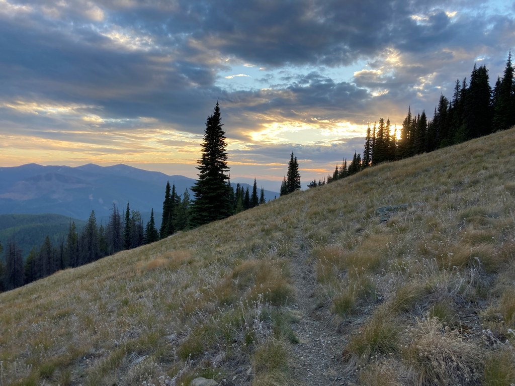
The Hall — Grassy Divide itself is about 5 miles one-way, opening up many possibilities for overnight and multi-day trips on the Sullivan Lake Ranger District. The trail crosses through forested areas and also includes wildflower-filled alpine meadows. A portion of the trail has been impacted by two major wildfires in recent years, leading to sections with big views but little shade, and downfall trees may be an obstacle to contend with both early season and following windstorms. The only drawback is that there is no access to water along this trail, so be sure to carry enough to hike through, or plan campsites along the Noisy Creek and Grassy Top feeder trails.

Toilet Information

  • No toilet at trailhead

More information about toilets

Hike Description Written by
Holly Weiler, WTA Correspondent

Hall - Grassy Divide

Map & Directions

Trailhead
Co-ordinates: 48.7970, -117.1320 Open in Google Maps

Before You Go

Wildfire: Trail closed

See weather forecast

Parking Pass/Entry Fee

None

WTA Pro Tip: Save a copy of our directions before you leave! App-based driving directions aren't always accurate and data connections may be unreliable as you drive to the trailhead.

Getting There

Noisy Creek trailhead: From Sullivan Lake Road, turn into the Noisy Creek Campground. The Noisy Creek trailhead is located between the group site and main part of the campground. Please note that parking in the campground or day-use area requires a fee. The trailhead itself is free parking.

Johns Creek trailhead: From Sullivan Lake Road, turn east on Sullivan Creek Road (FS 22). Drive 3.1 miles to Johns Creek Road; turn right and follow it 7 miles to the trailhead. Please note that Johns Creek trailhead is only open from July 1-August 15 each summer.

Pass Creek Pass: From Sullivan Lake Road, turn east on Sullivan Creek Road (FS22). Continue 5.3 miles to the intersection with FS2220 and continue slightly right toward Priest Lake for an additional 6.9 miles. A small trailhead/pull-out is located on the right just beyond the trailhead.

More Hike Details

Trailhead

Eastern Washington > Selkirk Range

Hall Grassy Divide (#533)

Colville National Forest, Sullivan Lake Ranger District

Guidebooks & Maps

Colville National Forest Map

Salmo-Priest Wilderness Map

USGS Metaline Falls

USGS Pass Creek

USGS Helmer Mountain

You can improve or add to this guidebook entry!

Hall - Grassy Divide

3 Trip Reports

Hiked here recently?

Submit a trip report!
 
Trip Reports